
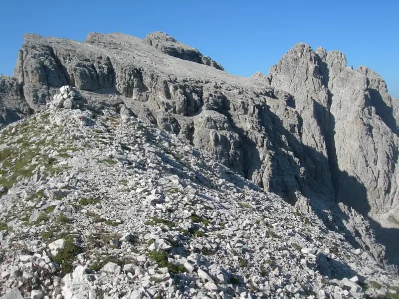
Sentiero Attrezzato Simone
Creton dell'Arco · Udine · Italy
Technical data
- Difficulty
- Moderatamente Difficile
- Status
- aperta
- Distance
- 15 km
- Total duration
- 8 h
- Approach
- 1 h 45 min
- Ferrata time
- 1 h 15 min
- Elevation gain
- 250 m
- Max altitude
- 2357 m
Route planning
How to plan Sentiero Attrezzato Simone
Sentiero Attrezzato Simone is in Creton dell'Arco, Udine, Italy and is rated Moderatamente Difficile. Available route data lists about 8 h total time, 15 km of distance, 250 m of elevation gain.
For day planning, consider an approach of about 105 min, about 75 min on the cable, a maximum altitude near 2357 m. Reported route features include: Itinerario lungo.
The page includes a parking or driving-directions reference. A GPX track is not available yet, so bring an alternative map source.
As with every via ferrata, evaluate season, lingering snow, storms, crowds and equipment condition. Page last updated on 7/4/2026.
Features
Description
Overview
The Sentiero Attrezzato Simone is a medium-difficulty route that, starting from Sappada in the Carnic Alps, leads to the summit of Creton dell'Arco. Inaugurated in 2010 and dedicated to the memory of alpine rescuer Simone Piller Hoffer, it offers a rewarding experience in a relatively secluded setting, characterized by wide panoramic openings. The route can be tackled as a standalone outing or, by well-trained hikers with adequate technical preparation, combined with the more challenging Ferrata dei Cinquanta del Clap, located in the immediate vicinity.
Approach
The start is set at the town of Sappada, in the province of Udine. Once you reach the village, head to the southern side of the Piave River, passing a camper parking area, until you reach a large clearing used as a parking lot (about 1180 m). From here, taking the trail, you skirt the sport fishing pond and proceed along the right orographic bank of the Rio Storto on trail 317. The track climbs decisively through the forest via a series of switchbacks; it is essential to ignore the right-hand turnoff (marker 322) for the Bivacco Damiana, which will instead serve as a possible return variant. The ascent continues until you reach Passo dell'Arco (1907 m), recognizable by its characteristic rock arch, in about 1 hour and 30 minutes from the parking lot. Shortly before the pass, on the right, a well-evident track indicates the access to the via ferrata: taking it, you soon arrive at the start of the first equipped section, after a total of about 1 hour and 45 minutes from the start. The approach unfolds entirely in a forest environment, with a steady and sustained pace, physically preparing you for the effort ahead.
Via Ferrata
The equipped route begins with a detrital gully with a partially grassy and loose floor, overcome thanks to the presence of cables. Reaching a ledge, you traverse it toward the rock walls until you spot the actual entrance to the ferrata, located in a gorge. This is ascended using some metal stirrups as well. You then proceed along the entire gully, where protected sections alternate with short stretches of trail of modest difficulty. The morphology is typical of an erosional groove, with solid rock but often interspersed with ledges and small gullies. After overcoming the gully, you tackle the last section of the route, which is also the most technically demanding. Using cables and stirrups, you execute an exposed traverse to the right, with excellent holds, leading to the base of a chimney. This passage, well-equipped but more strenuous than the average of the route due to its verticality, finally brings you to the summit slope. Following a clear track and the white-red trail markers, you thus reach the top of Creton dell'Arco at 2357 meters in altitude. The ferrata takes about 1 hour and 15 minutes to complete, for a total of 3 hours from the start. The pace is discontinuous, with sequences of vertical progression interspersed with walking stretches, while the exposure becomes significant especially in the final traverse and the chimney.
Descent
From the summit of Creton dell'Arco, there are mainly two return options. The first and most direct is to retrace the Ferrata Simone in reverse, taking about 2 hours from the summit for a total round trip of 5 hours. The second option, much more challenging and reserved for experienced hikers, involves connecting to the nearby Ferrata dei Cinquanta del Clap. From the summit, descend southwest via equipped sections to a clearly visible notch. Ascend the opposite side of the notch, again with exposed and protected passages, until you intercept the Ferrata dei Cinquanta del Clap. From here, it is not recommended to descend along it (as it would involve descending a very difficult section), while it is advised to continue it clockwise toward the west, overcoming vertical and exposed passages, until the summit of Creton di Culzei (2458 m). The descent then continues westward along a steep trail that, bending right, meets trail 232. This leads to the Bivacco Damiana (1980 m); from here, following the approach trail in reverse, you return to the parking lot. This loop variant requires about 8 hours total and transforms the itinerary into a route with alpine commitment, with a very variable pace and continuous ups and downs.
Useful Notes
Defining this itinerary as a simple equipped trail is perhaps reductive, as it features a couple of passages that require good physical preparation. Considered in its development up to Creton dell'Arco and back via the same route, it maintains a medium difficulty. The commitment, both technical and physical, increases significantly if you choose to combine it with the Ferrata dei Cinquanta del Clap to form a loop. The environment is very pleasant and offers splendid panoramas over this portion of the Carnic Alps, with a character that ranges from equipped hiking to rock climbing. In the Sappada area, there are other interesting alpine opportunities, such as the Ferrata Sartor, the Ferrata del Chiadenis, and the Sentiero d'Ambros alla Cresta di Pitturina.
Track and weather
Plan the route
Preview the GPX track from the backend, download it for your GPS device, open parking directions, and check a short forecast before leaving.
GPX track unavailable
This route does not include a downloadable track yet.
Images
FAQ
What level of commitment does this via ferrata require?
ferrata.faqAnswers.commitment
How much elevation gain should I plan for?
The listed ferrata elevation gain is 250 m. Also consider approach, return and maximum altitude, because they can matter more than the equipped section alone.
Where is the route located?
Sentiero Attrezzato Simone is located in Creton dell'Arco, Udine, Italy. Before leaving, check parking, access and current local conditions.
When is the best time to climb it?
The best season depends on altitude, aspect and lingering snow. Avoid storms, wet rock and uncertain conditions; start early and keep a margin for the return.
Gear and safety planning
Use the technical data on this page to plan equipment, timing and offline navigation. For a general checklist, read the equipment guide before opening the route in the app.
Video
Watch the route
Useful YouTube videos for getting a real feel for the route before you go.
Logbook
Route condition reports
Recent community notes about closures, snow, equipment damage, trail issues and current conditions.
Community
Reviews, check-ins and photos
-
0 reviews
0
0 climbers
0
Shared by the community
Community photos
Recent images uploaded by Sferrati members.
No community photos yet
Open this route in the app to add the first photo.
Reviews
Recent impressions from climbers who know the route.
No reviews yet
Be the first to review this via ferrata from the app.
Continue in the app
Track the climb, save maps offline, and sync this route to your personal profile.
Use the app to climb
Offline maps, tracking, saves, and profile sync.
Scan the code before leaving, install the app, and keep your route data ready when reception fades.
