
Sentiero Attrezzato d'Ambros
Cresta Pitturina · Belluno · Italy
Technical data
- Difficulty
- Moderatamente Difficile
- Status
- aperta
- Distance
- 12 km
- Total duration
- 6 h
- Approach
- 1 h 45 min
- Ferrata time
- 2 h
- Elevation gain
- 813 m
- Max altitude
- 2486 m
Route planning
How to plan Sentiero Attrezzato d'Ambros
Sentiero Attrezzato d'Ambros is in Cresta Pitturina, Belluno, Italy and is rated Moderatamente Difficile. Available route data lists about 6 h total time, 12 km of distance, 813 m of elevation gain.
For day planning, consider an approach of about 105 min, about 120 min on the cable, a maximum altitude near 2486 m. Reported route features include: Scale, Itinerario lungo, Interesse Storico, Galleria.
The page includes a parking or driving-directions reference. A GPX track is not available yet, so bring an alternative map source.
As with every via ferrata, evaluate season, lingering snow, storms, crowds and equipment condition. Page last updated on 7/4/2026.
Features
Description
Overview
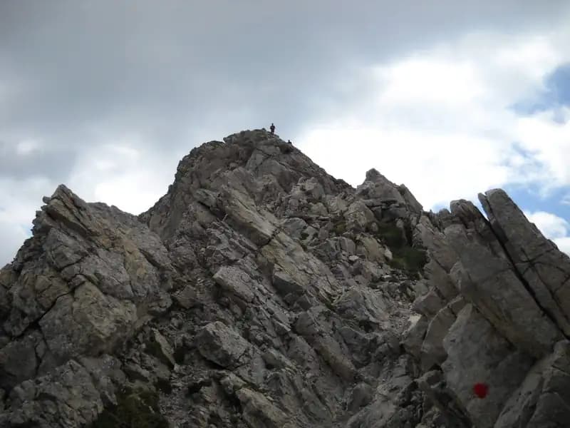
The Sentiero Attrezzato d'Ambros is an alpine route that traces the sharp border between Italy and Austria, linking Monte Cavallino and Cima Vallona. The itinerary unfolds entirely along the spectacular, razor-edged Cresta Pitturina, offering continuous exposure and 360-degree panoramas, yet never presenting extreme technical difficulties. The crest's morphology-thin and jagged-ensures an exhilarating progression, with views sweeping across the intricate system of the Carnic Alps and the majestic bulk of the Sexten Dolomites.
Approach
The starting point is Casera Melin (1673 m), in the municipality of San Nicolò di Comelico (BL). It is reached via a narrow paved road that climbs from Sega Digon, itself accessible from the SS 52 Carnica state road. From Casera Melin, take trail 144, signposted for Bivacco Piva and the Sentiero Attrezzato d'Ambros. The ascent begins steeply on trail 161, then branches right onto trail 144, which unfolds with a long series of switchbacks. In about an hour and a quarter, you reach Bivacco Piva (2250 m). Just before the bivouac, follow the trail markers to the right toward Cima Vallona on trail 191. With a steep climb, head toward the summit until you spot a track that veers left toward a border saddle. Right at this saddle, about thirty minutes from Bivacco Piva (for a total of roughly 1 hour and 45 minutes from the parking lot), lies the start of the Sentiero Attrezzato d'Ambros. The approach, though lengthy, physically and mentally prepares you for the alpine environment, gradually introducing the hiker to the panoramas and isolation of the crest.
Via Ferrata
The route runs entirely along the Italian-Austrian border crest, a rocky thread separating the two sides. It begins with about fifteen meters of easy diagonal traverses, then tackles a first unprotected section of crest: the exposure is immediate and intense, but the lack of technical difficulty allows you to acclimate to the environment. A second equipped section lets you continue on the left side of the ridge, staying on the Italian side. The path then descends toward a distinctive rocky pinnacle, traversing ledges and highly exposed traverses, always with good footholds, in a balancing act typical of ridge routes. The rock, solid and compact, ensures secure progression despite the void on either side.
You reach a first cave, visible from the crest, then climb some small rock steps and enter a series of three tunnels; for the last one, with an unstable floor, a headlamp is useful. Exiting the tunnels, a ladder brings you back onto the crest. Continue along the sharp ridge to a wide grassy saddle, where there is an escape route that should be ignored. This section is characterized by a continuous rhythm, with few natural resting spots.
The route continues just below the crest, alternating between the Italian and Austrian sides, in a more pronounced descent that leads to a chimney to be descended carefully. After crossing an equipped saddle, you encounter the key passage of the route: a short traverse across a slab that demands concentration, being the most challenging section of the entire itinerary. Here, movement technique and trust in the cable become essential.
Next, you face an 8-10 meter descent on a well-holded wall, then climb an equipped gully that returns you to the crest. Here, in good exposure, you alternate between unprotected sections and a cable-protected stretch, until reaching the highest point of the ridge. A final trail section leads to the end of the Sentiero Attrezzato d'Ambros, marked by a marble border block. The via ferrata takes about two hours to complete, for a total of roughly four hours from the start of the hike. The pace is sustained but not frantic, with a progression that alternates short vertical sections with long horizontal traverses, keeping engagement high throughout.
Descent
From the end of the equipped trail, you can detour to reach the summit of Monte Cavallino in one hour, following tracks over scree and small rock steps to the summit cross (round trip about 1 hour and 45 minutes). To return to Casera Melin, descend on the Italian side by taking trail 160, which runs parallel to the crest you just traveled and leads back to Bivacco Piva. From there, return via the ascent route. This descent takes about two hours from the end of the via ferrata, for a total hike of roughly six hours. There are some more direct but also more challenging descent variants compared to the main trail described. The descent on trail 160 offers a different perspective on the crest just traversed, highlighting its grandeur and extent.
Useful Notes
Although called an "equipped trail," the route features several vertical sections that bring it closer to a true via ferrata. The technical difficulties are not high, with only three or four slightly more demanding points. The predominant characteristic is the strong exposure, typical of ridge itineraries, present for almost the entire length of the route. The character of the route is therefore more scenic and psychological than physically extreme. Caution is recommended during the descent, as the trail markings are not always impeccable. It is essential to be equipped with a complete via ferrata kit (harness, energy-absorbing lanyard, helmet) and a headlamp for the tunnels. The experience is recommended for those already familiar with exposure and high-altitude environments.
Track and weather
Plan the route
Preview the GPX track from the backend, download it for your GPS device, open parking directions, and check a short forecast before leaving.
GPX track unavailable
This route does not include a downloadable track yet.
Images
FAQ
What level of commitment does this via ferrata require?
ferrata.faqAnswers.commitment
How much elevation gain should I plan for?
The listed ferrata elevation gain is 813 m. Also consider approach, return and maximum altitude, because they can matter more than the equipped section alone.
Where is the route located?
Sentiero Attrezzato d'Ambros is located in Cresta Pitturina, Belluno, Italy. Before leaving, check parking, access and current local conditions.
When is the best time to climb it?
The best season depends on altitude, aspect and lingering snow. Avoid storms, wet rock and uncertain conditions; start early and keep a margin for the return.
Gear and safety planning
Use the technical data on this page to plan equipment, timing and offline navigation. For a general checklist, read the equipment guide before opening the route in the app.
Video
Watch the route
Useful YouTube videos for getting a real feel for the route before you go.
Logbook
Route condition reports
Recent community notes about closures, snow, equipment damage, trail issues and current conditions.
Community
Reviews, check-ins and photos
-
0 reviews
0
0 climbers
0
Shared by the community
Community photos
Recent images uploaded by Sferrati members.
No community photos yet
Open this route in the app to add the first photo.
Reviews
Recent impressions from climbers who know the route.
No reviews yet
Be the first to review this via ferrata from the app.
Continue in the app
Track the climb, save maps offline, and sync this route to your personal profile.
Use the app to climb
Offline maps, tracking, saves, and profile sync.
Scan the code before leaving, install the app, and keep your route data ready when reception fades.
