
Ferrata Aglio alla Tofana di Mezzo
Tofana di Mezzo · Belluno · Italy
Technical data
- Difficulty
- Difficile
- Status
- aperta
- Distance
- 3,2 km
- Total duration
- 8 h 30 min
- Approach
- 2 h 45 min
- Ferrata time
- 3 h
- Elevation gain
- 594 m
- Max altitude
- 3244 m
Route planning
How to plan Ferrata Aglio alla Tofana di Mezzo
Ferrata Aglio alla Tofana di Mezzo is in Tofana di Mezzo, Belluno, Italy and is rated Difficile. Available route data lists about 8 h 30 min total time, 3,2 km of distance, 594 m of elevation gain.
For day planning, consider an approach of about 165 min, about 180 min on the cable, a maximum altitude near 3244 m. Reported route features include: Alta montagna, Scale, Funivia all'andata, Funivia al ritorno.
The page includes a parking or driving-directions reference. A GPX track is available to review and download.
As with every via ferrata, evaluate season, lingering snow, storms, crowds and equipment condition. Page last updated on 7/4/2026.
Features
Description
Overview
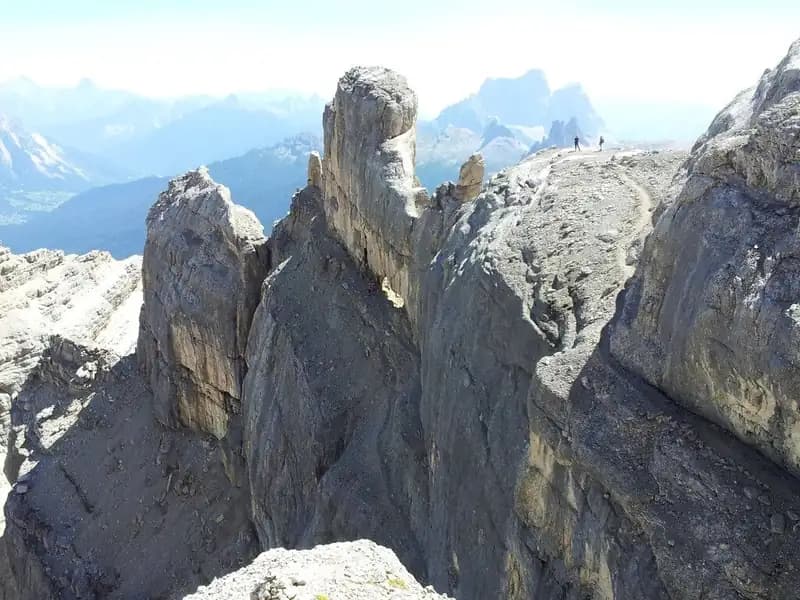
The Via Ferrata Aglio traces a bold line along the ridge connecting the Dos de Tofana to the summit of Tofana di Mezzo. Classified as a route of medium technical difficulty, it unfolds in a severe alpine setting where the challenge comes primarily from the altitude, the elevation gain, and a constant, pronounced exposure. The route demands a full day, considering both the approach and the return, and requires stable weather conditions.
The itinerary develops mainly along the crest, offering continuous and at times physically demanding progression. The morphology is typically Dolomitic, with passages over polished slabs, chimneys, and airy ledges that follow one another without interruption, guaranteeing an exceptional panoramic experience across the entire Tofane group.
Approach
The logical starting point is the Rifugio Dibona (2,083 m), accessible from Cortina d'Ampezzo. An alternative is to start from Baita Piè Tofana, using the lifts or a trail to reach high altitude.
To reach the actual start of the via ferrata on the Dos de Tofana (2,850 m) from Rifugio Dibona, there are three main choices. The first is to climb to Rifugio Pomedes in about 45 minutes along trail 421, then traverse the entire Ferrata Olivieri; the whole approach takes roughly 2 hours and 45 minutes. The second option, again from Pomedes, takes the Sentiero Attrezzato Olivieri, then branches off into a steep, debris-filled gully for the final ascent to the Dos, taking about 3 hours and 30 minutes. The third possibility follows trail 403 toward Rifugio Giussani, turning off before the refuge onto a steep, partially equipped track that converges with the final meters of the Ferrata Olivieri, for a similar duration of about 2 hours and 45 minutes.
The approach is therefore an integral part of the day's commitment. The choice of route determines the initial pace: the option via Ferrata Olivieri is more technical and direct, while the ascent through the debris gully is more physical and less equipped.
Via Ferrata
From the Dos de Tofana, the route immediately rises to the right with a series of switchbacks that lead to the crest line. This introductory section already offers a majestic view of the south face of Tofana di Rozes. Once on the actual ridge, you follow a well-stepped ramp that leads to a broad, panoramic ledge-a wide passage but with notable exposure that foreshadows the character of the entire traverse.
The route continues along the equipped crest with easy sections, until a first rocky step is overcome with the help of a metal ladder. After a short stretch of debris-covered ridge, a second step is tackled on the left side with vertical passages and some stirrups, including a brief, slightly overhanging section that requires good balance management. You pass through a notch and traverse a ledge on the western side, heading toward a distinctive saddle (2,920 m), where a fixed rope secures the crossing.
Immediately after the saddle, the pace quickens. You climb a dihedral about ten meters high with the cable on the left and stirrups, followed by a wall of about fifteen meters to be ascended diagonally to the right; here the moves may require actively pulling on the rope.
Just beyond, you encounter the junction for the "Variante Aglio", a deviation of about 30 meters for the ascent of Torre Aglio. This short spur, on friable rock with sparse holds, is a very airy and demanding excursion, reserved for the most experienced hikers. Back on the main route, after rounding an edge with the help of pegs, you face a horizontal traverse that is extremely exposed and slightly overhanging. This is one of the key passages of the via ferrata, where concentration must be at its peak despite the excellent assistance of the cables.
The ridge continues with a descending section over small rocks to a recess above the Bus de Tofana (2,900 m), a point where there is an escape route to the right toward Rifugio Ra Vales. Following the signs for "Cima," you begin a long, nearly horizontal stretch-a succession of ledges and short steps that maintain constant exposure. You reach a slab equipped with stirrups that introduces a chimney, climbed comfortably on the left side thanks to numerous artificial holds, exiting to the right onto an exposed traverse.
A steep vertical climb with many stirrups leads to a ledge. From here, you move toward the smaller Bus de Tofana to tackle two metal ladders that lead up a vertical, exposed section with polished rock. Once past this, you traverse a broad ridge, pass avalanche nets, and climb a sloping slab until reaching a new vertical wall served by two short ladders.
The final stretch of ridge leads beneath the summit. You do not climb directly vertically, but stay on the right side, overcoming a few steps and one last short ladder. The final meters to the summit cross of Tofana di Mezzo (3,244 m) are on un-equipped switchbacks, in a landscape of rock and high-altitude debris.
The development of the via ferrata is predominantly horizontal and traversing, with continuous ups and downs that demand effort without respite. The environment is pure ridge, with solid but often polished rock from erosion, requiring attention to the choice of natural holds despite the excellent provision of stirrups and ladders.
Descent
From the summit, the initial descent proceeds north, toward the top station of the cable car. At the next junction, two options present themselves. The first descends to the right toward Rifugio Cima Tofana (3,190 m), from where you can take the cable car. Descending to the intermediate station at Rifugio Ra Vales (2,470 m), you briefly climb a slope to the left to pick up the descending Sentiero Attrezzato Olivieri toward Rifugio Pomedes and, finally, Rifugio Dibona.
The second option, from the junction, descends instead toward Tofana di Dentro, following the equipped ridge (the first section of the Ferrata del Formenton) to Forcella di Tofana and then to Forcella del Vallon. From here, an exposed trail cuts across the western wall at mid-height, then descends to a steep scree slope that leads to Rifugio Giussani and, along the broad trail, back to Rifugio Dibona.
The choice of descent strongly influences the end of the day. The cable car option is quick but tied to operating hours, while the entirely pedestrian route via Forcella del Vallon is longer and more technical, but self-reliant.
Useful Notes
The Ferrata Aglio is often combined with the nearby Ferrata Olivieri in a challenging link-up. Although it is rich in ladders and stirrups that facilitate progression, it maintains a good overall level of difficulty, determined by the high-altitude environment, the cumulative elevation gain, the length, and above all, the pervasive exposure that characterizes every meter.
It is considered one of the most panoramic via ferratas in the Dolomites. In high season, traffic can be heavy: it is advisable to start at dawn to avoid queues at the more technical passages. It is essential to check in advance the operational status of the lifts, as their possible closure would make the return very long and tiring. The Tofane group offers numerous possibilities for linking with other via ferratas and equipped trails in the surrounding areas, allowing you to tailor the commitment to your own preparation.
Track and weather
Plan the route
Preview the GPX track from the backend, download it for your GPS device, open parking directions, and check a short forecast before leaving.
Images
FAQ
What level of commitment does this via ferrata require?
ferrata.faqAnswers.commitment
How much elevation gain should I plan for?
The listed ferrata elevation gain is 594 m. Also consider approach, return and maximum altitude, because they can matter more than the equipped section alone.
Where is the route located?
Ferrata Aglio alla Tofana di Mezzo is located in Tofana di Mezzo, Belluno, Italy. Before leaving, check parking, access and current local conditions.
When is the best time to climb it?
The best season depends on altitude, aspect and lingering snow. Avoid storms, wet rock and uncertain conditions; start early and keep a margin for the return.
Gear and safety planning
Use the technical data on this page to plan equipment, timing and offline navigation. For a general checklist, read the equipment guide before opening the route in the app.
Video
Watch the route
Useful YouTube videos for getting a real feel for the route before you go.
Logbook
Route condition reports
Recent community notes about closures, snow, equipment damage, trail issues and current conditions.
Community
Reviews, check-ins and photos
-
0 reviews
0
0 climbers
0
Shared by the community
Community photos
Recent images uploaded by Sferrati members.
No community photos yet
Open this route in the app to add the first photo.
Reviews
Recent impressions from climbers who know the route.
No reviews yet
Be the first to review this via ferrata from the app.
Continue in the app
Track the climb, save maps offline, and sync this route to your personal profile.
Use the app to climb
Offline maps, tracking, saves, and profile sync.
Scan the code before leaving, install the app, and keep your route data ready when reception fades.
