
Technical data
- Difficulty
- Difficile
- Status
- aperta
- Distance
- 11 km
- Total duration
- 5 h
- Approach
- 1 h 45 min
- Ferrata time
- 1 h
- Elevation gain
- 216 m
- Max altitude
- 2166 m
Route planning
How to plan Ferrata Bovero al Col Rosà
Ferrata Bovero al Col Rosà is in Col Rosà, Belluno, Italy and is rated Difficile. Available route data lists about 5 h total time, 11 km of distance, 216 m of elevation gain.
For day planning, consider an approach of about 105 min, about 60 min on the cable, a maximum altitude near 2166 m. Reported route features include: Ferrata breve ma impegnativa, Panorami mozzafiato, Richiede buona preparazione fisica, Tratti verticali e aerei.
The page includes a parking or driving-directions reference. A GPX track is available to review and download.
As with every via ferrata, evaluate season, lingering snow, storms, crowds and equipment condition. Page last updated on 7/4/2026.
Features
Description
Overview
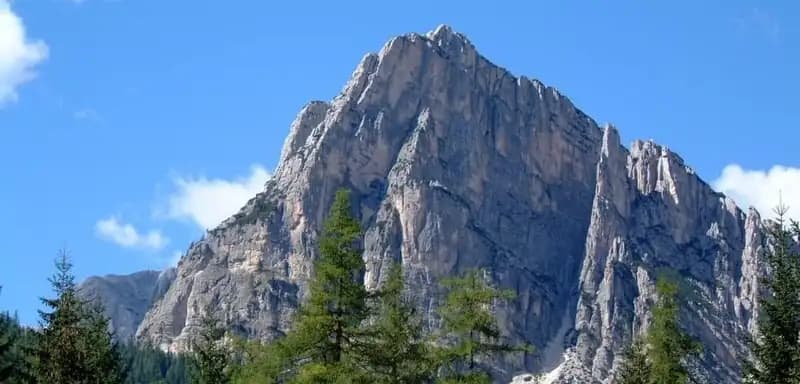
The Ferrata Ettore Bovero, which leads to the summit of Col Rosà above Cortina d'Ampezzo, is a route with a distinctly alpine character. Though not particularly long in terms of distance, it is an extremely demanding, airy, and relentlessly vertical via ferrata that demands solid technique and a complete absence of vertigo. The progression is varied and engaging, alternating between slabs, dihedrals, chimneys, and exposed traverses. The second part of the route includes unprotected sections of Grade I scrambling. The final reward is a breathtaking 360-degree panorama from the summit cross.
Approach
The itinerary begins from the large parking area at the entrance of the Campeggio Olympia in Fiames, north of Cortina d'Ampezzo. From here, take the wide forest road marked with trail marker 417, which climbs steeply northward with the imposing silhouette of Col Rosà on the left. In about 25 minutes you reach Pian de Ra Spines (1301 m). At this point, turn left onto trail 408, which enters the woods with a steady, steep gradient up to Passo Posporcora (1711 m), reached after a total of 1 hour and 15 minutes.
Continue, ignoring the left fork for trail 409, staying on trail 408 until you spot the right-hand turn for trail 447, signposted for Col Rosà and the Ferrata Bovero. The final stretch of the approach is steep, over rocky steps, ledges, and small crags. It is advisable to put on your harness on a small terrace before the last rocky rises, which in a few minutes lead to a metal plaque and the actual start of the fixed cables at 1950 meters elevation, after approximately 1 hour and 45 minutes total from the start.
Via Ferrata
The equipped climb begins immediately with a smooth dihedral lacking good holds, revealing the technical nature of the ascent from the very first moves. After overcoming it, you enter a narrow gully to be climbed on the right side, then emerge onto a small terrace. A short unroped trail section leads to the base of a sloping, well-stepped slab, which is climbed easily. From a new ledge, you tackle a vertical wall at a second dihedral, equally polished on the right side but with slightly better holds near a crack on the left.
The progression becomes extremely exposed as the cable runs inside a tight crack; from a small terrace on the right, you must pull up a couple of meters searching for holds to reach the first solid footholds. After this challenging passage, continue vertically on stepped rock up to a third key dihedral, with the cable on the right. Here, some good holds on the left and a couple of athletic moves, almost in a split, allow you to overcome what is likely the hardest passage of the entire route.
Emerging onto a panoramic pulpit, move right onto a very exposed arête, tackled diagonally and then straight on for about ten meters. The cable bends to the right of the arête, crossing diagonally through a technical and airy crack, to be climbed by seeking holds on both sides. After this, the climb resumes vertically on a jagged but overhanging wall, near a crack in the rock. You skirt a rock bulge on the left side, execute an exposed traverse to the left to go around an arête, and climb vertically again, first left to a small balcony and then right onto a more hold-filled but still vertical wall.
You then find yourself beneath a roof, overcome with a challenging move by seeking holds in yet another crack, to emerge onto the upper rocks. A final diagonal to the left, less difficult, concludes the first equipped section. A connecting trail, with some scrambling over small rocks (Grade I) among stones and dwarf pines, leads to the final sector. After a short step aided by the cable, continue on the trail until you encounter, to the left of a chimney, a first series of wide metal stirrups. Climb them, clipping directly into them.
A few meters of trail lead to a second series of stirrups that help ascend the left side of a dihedral. Then proceed on an unprotected trail, overcoming some stepped rocky ledges that lead into a gully. On the left side, some stirrups assist on the steepest sections. After a few final Grade I rock steps, you exit the gully onto the summit plateau of Col Rosà (2166 m). The panoramic view of the surrounding Dolomites is magnificent. The climbing time for the via ferrata is about 1 hour, for a total of 2 hours and 45 minutes from the parking lot.
Descent
From the summit cross of Col Rosà, descend northward following the markers of the CAI trail 447. The trail is clear and leads to a debris-filled gully, which you descend partly before traversing at mid-height toward a distinctive, visible rock tower. After passing it, descend steeply into the woods until you join the wide forest road of trail 417 at about 1300 meters elevation (approximately 1 hour and 30 minutes from the summit). Keeping right, you return in 30 minutes to the parking lot of the Campeggio Olympia in Fiames. The total descent time is about 2 hours, for a full excursion of 5 hours.
Useful Notes
The Ferrata Bovero is an intense and extremely exposed route. The relatively short duration of the equipped climb should not be misleading: this is a nearly continuous and vertical progression, with passages on dihedrals, chimneys, and traverses that demand focus and technique. The rock alternates between excellent sections and others that are polished and lacking in holds. The condition of the equipment is not optimal: the bolting is sparse, with sometimes excessive distances between the pegs that can generate a high fall factor. In a couple of spots, the cable is slack, an additional difficulty on such a vertical route. Be cautious on some exposed sections during the descent. The itinerary is completely devoid of intermediate refuges and water sources; you must be fully self-sufficient.
Track and weather
Plan the route
Preview the GPX track from the backend, download it for your GPS device, open parking directions, and check a short forecast before leaving.
Images
FAQ
What level of commitment does this via ferrata require?
ferrata.faqAnswers.commitment
How much elevation gain should I plan for?
The listed ferrata elevation gain is 216 m. Also consider approach, return and maximum altitude, because they can matter more than the equipped section alone.
Where is the route located?
Ferrata Bovero al Col Rosà is located in Col Rosà, Belluno, Italy. Before leaving, check parking, access and current local conditions.
When is the best time to climb it?
The best season depends on altitude, aspect and lingering snow. Avoid storms, wet rock and uncertain conditions; start early and keep a margin for the return.
Gear and safety planning
Use the technical data on this page to plan equipment, timing and offline navigation. For a general checklist, read the equipment guide before opening the route in the app.
Video
Watch the route
Useful YouTube videos for getting a real feel for the route before you go.
Logbook
Route condition reports
Recent community notes about closures, snow, equipment damage, trail issues and current conditions.
Community
Reviews, check-ins and photos
-
0 reviews
1
1 climbers
0
Shared by the community
Community photos
Recent images uploaded by Sferrati members.
No community photos yet
Open this route in the app to add the first photo.
Reviews
Recent impressions from climbers who know the route.
No reviews yet
Be the first to review this via ferrata from the app.
Continue in the app
Track the climb, save maps offline, and sync this route to your personal profile.
Use the app to climb
Offline maps, tracking, saves, and profile sync.
Scan the code before leaving, install the app, and keep your route data ready when reception fades.
