
Ferrata Brigata Alpina al Col dei Bos
Col dei Bos · Belluno · Italy
Technical data
- Difficulty
- Difficile
- Status
- aperta
- Distance
- 4,5 km
- Total duration
- 3 h 45 min
- Approach
- 30 min
- Ferrata time
- 2 h
- Elevation gain
- 323 m
- Max altitude
- 2559 m
Route planning
How to plan Ferrata Brigata Alpina al Col dei Bos
Ferrata Brigata Alpina al Col dei Bos is in Col dei Bos, Belluno, Italy and is rated Difficile. Available route data lists about 3 h 45 min total time, 4,5 km of distance, 323 m of elevation gain.
For day planning, consider an approach of about 30 min, about 120 min on the cable, a maximum altitude near 2559 m. Reported route features include: Avvicinamento corto, Interesse Storico.
The page includes a parking or driving-directions reference. A GPX track is available to review and download.
As with every via ferrata, evaluate season, lingering snow, storms, crowds and equipment condition. Page last updated on 7/4/2026.
Features
Description
Overview
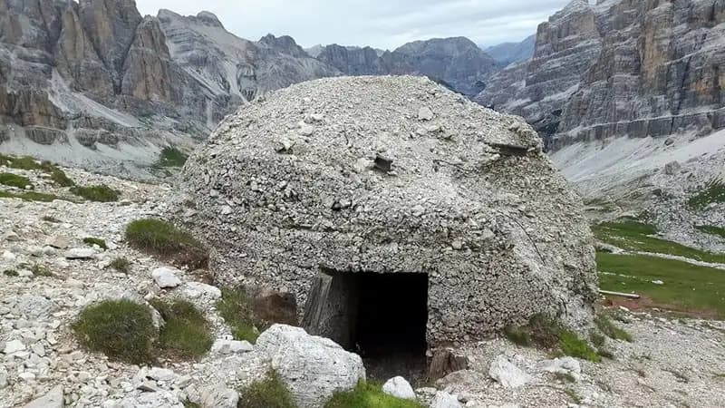
The Ferrata Brigata Alpina al Col dei Bos is a moderately difficult, recently equipped route that offers a well-balanced and satisfying physical and technical challenge. It unfolds along the compact western wall of Col dei Bos, a pyramidal peak that rises strategically between the Dolomite groups of the Tofane and Lagazuoi, guaranteeing exceptional 360-degree panoramas. The itinerary follows a logical and well-designed line, developing across a slope rich in history, dotted with remains and trenches from the Great War, which enrich the surrounding environment.
Approach
The starting point is the Ristorante Strobel, located on the Veneto side of Passo Falzarego (reachable from San Cassiano or Cortina d'Ampezzo). Descending from the pass toward Cortina for about a kilometer, you'll spot the restaurant on the left with ample parking, directly at the foot of Col dei Bos. From here (2060 m), take an unnumbered CAI trail, marked for the via ferrata. Cross a small wooden bridge over the Rio Lagazuoi and ascend at a steady grade on a well-defined path. Ignoring a left fork, you reach a wide military mule track (2170 m, about 20 minutes). Keeping right, continue past some war ruins to a marked junction. From here, head northeast on a thinner trail that aims directly for the summit, being careful not to take the zigzag path to the north (which will be the return route). Shortly, you arrive at the base of the wall, at the start of the via ferrata (2200 m, 30 minutes total from the start).
Via Ferrata
The route begins immediately with its most characteristic and technical passages. Looking at the rock, you'll notice two distinct vertical cracks, slightly leaning to the left, which define the first section. The climb starts right at the first crack: ascend about 6 meters using good natural holds, possibly using the cable for the initial moves. After this, a short 4-meter traverse to the right, with an easy step across a gap, leads to the base of the second, more challenging crack, which takes the form of a 10-12 meter dihedral. This is the crux of the entire route: the rock is polished and offers few holds, requiring a certain amount of pulling strength, especially in the first, smoother 3 meters. After overcoming the dihedral with the help of a stirrup and a few meager holds, continue on small rocks and then along a ledge to the left.
You then arrive at another significant section: ascending a very exposed arete. The first meters are tackled by straddling a small pillar, then climb diagonally to bypass a roof. Here, a stirrup may feel a bit far from the cable. After it, the cable continues vertically for 4 challenging meters to a second stirrup, beyond which the rock becomes more slabby, concluding the first section.
The character of the route changes: after some easy rock steps to the right, you face a very airy horizontal traverse, but with good footholds. This leads to an arete that is climbed in strong exposure on excellent rock. A trail section follows, then some equipped rock steps and another short trail that introduces the next section.
Climb rock steps, traverse left, and ascend more rock steps. A new diagonal traverse, without particular difficulties, leads to an exposed arete that you climb and descend on the opposite side. A connecting section (easy rock steps and an equipped trail) leads to the next wall.
This new wall begins with vertical meters but with good holds. More challenging is the subsequent diagonal traverse to the left, followed by a vertical wall with excellent footholds. A transfer ledge to the right introduces another well-equipped vertical step. After exiting this passage, proceed left on a trail with rock steps and undulations to a debris saddle. Here, to the left (red mark), an escape route begins in a steep descent toward the trail below. Another escape possibility continues mid-slope on a ledge to the return trail. For those continuing, after a short trail section, you encounter the final wall.
This final part is rich in interesting passages: a short diagonal traverse to the left with scarce holds, followed by a very exposed vertical passage but with better holds. Another traverse introduces a wall of about ten meters, pleasantly climbable. Reaching a notch, a series of rock steps to the left precedes the last challenge: a wall of about twenty meters that ascends a crack rich in holds, allowing you to climb without excessive pulling on the cable. This is the concluding section that leads to the summit plateau of Col dei Bos (2559 m). The climbing time from the start is about 2 hours, for a total of 2 hours and 30 minutes from the beginning of the approach.
Descent
From the summit cross, follow the obvious trail in a northwest direction. The path descends along a gully, at times a bit slippery, returning to the junction near the start of the via ferrata in about 45 minutes. From here, return via the approach trail to the Ristorante Strobel parking lot in another 20 minutes, for a total hike time of about 3 hours and 45 minutes.
Useful Notes
The Ferrata Brigata Alpina is an excellent recent route, well-equipped and logically conceived on Col dei Bos, in the Lagazuoi Group. Although it starts with vertical and demanding passages, it never presents excessive difficulty. It remains very exposed for most of the route, but the majority of the passages are climbable and enjoyable. The Passo Falzarego area is a true paradise for via ferrata enthusiasts, with numerous other itineraries in the immediate vicinity, such as the Sentiero Attrezzato dei Kaiserjäger, the Ferrata Tomaselli, the Ferrata Averau, and those on the nearby Tofane.
Track and weather
Plan the route
Preview the GPX track from the backend, download it for your GPS device, open parking directions, and check a short forecast before leaving.
Images
FAQ
What level of commitment does this via ferrata require?
ferrata.faqAnswers.commitment
How much elevation gain should I plan for?
The listed ferrata elevation gain is 323 m. Also consider approach, return and maximum altitude, because they can matter more than the equipped section alone.
Where is the route located?
Ferrata Brigata Alpina al Col dei Bos is located in Col dei Bos, Belluno, Italy. Before leaving, check parking, access and current local conditions.
When is the best time to climb it?
The best season depends on altitude, aspect and lingering snow. Avoid storms, wet rock and uncertain conditions; start early and keep a margin for the return.
Gear and safety planning
Use the technical data on this page to plan equipment, timing and offline navigation. For a general checklist, read the equipment guide before opening the route in the app.
Video
Watch the route
Useful YouTube videos for getting a real feel for the route before you go.
Logbook
Route condition reports
Recent community notes about closures, snow, equipment damage, trail issues and current conditions.
Community
Reviews, check-ins and photos
-
0 reviews
1
1 climbers
0
Shared by the community
Community photos
Recent images uploaded by Sferrati members.
No community photos yet
Open this route in the app to add the first photo.
Reviews
Recent impressions from climbers who know the route.
No reviews yet
Be the first to review this via ferrata from the app.
Continue in the app
Track the climb, save maps offline, and sync this route to your personal profile.
Use the app to climb
Offline maps, tracking, saves, and profile sync.
Scan the code before leaving, install the app, and keep your route data ready when reception fades.
