
Technical data
- Difficulty
- Difficile
- Status
- aperta
- Distance
- 2,2 km
- Total duration
- 4 h 15 min
- Approach
- 15 min
- Ferrata time
- 1 h 45 min
- Elevation gain
- 200 m
- Max altitude
- 2911 m
Route planning
How to plan Ferrata Piz da Lech
Ferrata Piz da Lech is in Piz da Lech, Bolzano, Italy and is rated Difficile. Available route data lists about 4 h 15 min total time, 2,2 km of distance, 200 m of elevation gain.
For day planning, consider an approach of about 15 min, about 105 min on the cable, a maximum altitude near 2911 m. Reported route features include: Ponti sospesi, Scale, Avvicinamento corto, Funivia all'andata.
The page includes a parking or driving-directions reference. A GPX track is available to review and download.
As with every via ferrata, evaluate season, lingering snow, storms, crowds and equipment condition. Page last updated on 7/4/2026.
Features
Description
Overview
The Ferrata del Piz de Lech is a challenging route that ascends the eastern flank of the Sella Group, reaching its summit. The itinerary unfolds up a steep rocky bastion, offering an intense experience characterized by athletic passages and considerable exposure. Its commanding position guarantees a spectacular panorama from the top. Access is made quick by using the lifts from Corvara in Val Badia, which in just a few minutes bring you to altitudes above 2500 meters.
The environment is classic Dolomites: a compact, vertical wall that stretches for hundreds of meters. The route alternates between slab climbing and sections on ledges and gullies, providing a varied but continuous rhythm where rest stops are brief and exposure is constant. The character of the itinerary is decidedly vertical and technical, demanding confident movement on rock.
Approach
The recommended starting point is the top station of the Vallon chairlift at 2537 meters, reachable by cable car from Corvara in Val Badia. For those opting for a walking approach, you can park at Passo di Campolungo, near the Alberto Boè hut at 1860 meters, and follow the CAI trail 638 up to the same station, a walk of about one hour and fifteen minutes.
From the top station, ignore the signs for the normal route (646B) and follow the trail markers heading north, entering a debris-filled valley. A left turn uphill leads to the start of the via ferrata, at the foot of a distinctive yellow-black rock face at 2560 meters. This approach section takes about 15 minutes.
The initial setting is a debris cone at the base of the imposing bastion. The rock immediately appears compact and overhanging, signaling the vertical nature of the ascent ahead.
Via Ferrata
The route begins with a moderately difficult rock step, where holds must be sought out carefully. After overcoming this, you continue along an easy ledge to the left before tackling several rocky steps. After rounding a corner to the left via another ledge, you find yourself at the foot of the main bastion, where further steps follow. The climb then becomes vertical for a few meters, approaching a distinctive feature: a long gully that you ascend staying on the right side, overcoming several steps.
The gully progressively narrows, forcing a vertical climb of about fifteen meters. This is followed by a short but exposed and demanding traverse to the right, necessary to get around a corner and gain a ledge. From here, you head toward a very challenging passage: a chimney whose initial section is climbed on the right side, then shifts to the left with a step. This section is tricky at the start due to scarce holds, which become more plentiful in the upper part.
After overcoming some exposed rock steps, you reach the most iconic point of the via ferrata, at the foot of the bastion: here you find two metal ladders, separated by an airy rock passage aided by stirrups. Once the second ladder is finished, another demanding passage, again with the help of stirrups, introduces the final section.
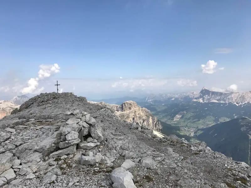
You ascend some exposed rock steps and a ramp that leads to a summit ridge. After a few meters with the cable on your right, you emerge onto a trail. Shortly after, you pick up the cable again, prelude to a short suspension bridge consisting of a horizontal ladder over a crevasse: the passage is exposed but not difficult. You then climb a short, well-holded wall (often damp) and, after a few rock steps, enter the final section: an unprotected high-altitude trail that leads to the summit cross. This trail, though wide, requires attention due to exposure. The summit of Piz de Lech (2916 m) is reached in about 1 hour and 45 minutes from the start (2 hours from the chairlift), rewarding you with a magnificent view of the Sella Group, Piz Boè, Val de Mesdì, and the surrounding Dolomites.
The pace is tight and physically demanding, with few horizontal sections for rest. Exposure is marked and continuous, especially in the gullies and on the ladders. The experience is predominantly vertical and technical, but the route also offers moments of progression on ledges and the spectacular crossing of the suspension bridge, culminating in an airy trail leading to the panoramic summit.
Descent
From the summit, descend south along the normal route, marked by the white-red CAI 646 trail markers on the scree slopes of the southern side. The descent features two equipped passages: a vertical wall of about 6-8 meters with stirrups and a short series of rock steps. It is advisable not to remove your harness after the via ferrata to tackle these sections safely.
Upon reaching a junction marked with CAI 646B, you have two options: Take the trail to the right (646B), which descends along a loose gully until it rejoins the approach trail, then return to the chairlift from the start. This option takes about 45 minutes from the summit, for a total of 2 hours and 45 minutes. Alternatively, continue descending on CAI 646, which leads along a panoramic ridge above Lago di Boè, until reaching the top station of the Boè cable car at 2198 meters. This variant takes about 1 hour and 15 minutes from the summit, for a total of 3 hours and 15 minutes.
The descent offers a clear change of pace, shifting from technical rock progression to walking on scree and trail. The CAI 646 option extends the experience in an open, panoramic environment along an airy ridge.
Useful Notes
The Ferrata del Piz de Lech is a short but intense itinerary, with some athletic passages that require good momentum or decent climbing technique. While not extremely difficult, it demands good physical preparation and experience. The summit ridge and the area around the cross are not very spacious and should be traversed with caution. The descent is steep. The via ferrata equipment is in excellent condition, having been recently renovated.
For navigation, detailed topographic maps of the area are recommended, such as those of Val Gardena, Val di Funes and Alpe di Siusi, Val di Fassa, or Val Badia. The itinerary lends itself to being combined, for those with enough energy, with the nearby Ferrata del Vallon, possibly with an overnight stay at Rifugio Kostner. Other via ferratas in the vicinity of the Sella Group include the Ferrata Piazzetta, the Ferrata Tridentina, and the Ferrata delle Mesules. Descending toward Corvara in Val Badia, you can find the Ferrata Sas dla Crusc, the Ferrata della Pace, and the Sentiero Attrezzato Tru Dolomieu.
This route is a classic of concentrated challenge: the proximity to the lifts should not deceive you about its technical and physical substance. The constant exposure and verticality of the key passages make it a selective route, suitable for those seeking an intense experience in a striking Dolomite environment.
Track and weather
Plan the route
Preview the GPX track from the backend, download it for your GPS device, open parking directions, and check a short forecast before leaving.
Images
FAQ
What level of commitment does this via ferrata require?
ferrata.faqAnswers.commitment
How much elevation gain should I plan for?
The listed ferrata elevation gain is 200 m. Also consider approach, return and maximum altitude, because they can matter more than the equipped section alone.
Where is the route located?
Ferrata Piz da Lech is located in Piz da Lech, Bolzano, Italy. Before leaving, check parking, access and current local conditions.
When is the best time to climb it?
The best season depends on altitude, aspect and lingering snow. Avoid storms, wet rock and uncertain conditions; start early and keep a margin for the return.
Gear and safety planning
Use the technical data on this page to plan equipment, timing and offline navigation. For a general checklist, read the equipment guide before opening the route in the app.
Video
Watch the route
Useful YouTube videos for getting a real feel for the route before you go.
Logbook
Route condition reports
Recent community notes about closures, snow, equipment damage, trail issues and current conditions.
Community
Reviews, check-ins and photos
-
0 reviews
1
1 climbers
0
Shared by the community
Community photos
Recent images uploaded by Sferrati members.
No community photos yet
Open this route in the app to add the first photo.
Reviews
Recent impressions from climbers who know the route.
No reviews yet
Be the first to review this via ferrata from the app.
Continue in the app
Track the climb, save maps offline, and sync this route to your personal profile.
Use the app to climb
Offline maps, tracking, saves, and profile sync.
Scan the code before leaving, install the app, and keep your route data ready when reception fades.
