
Technical data
- Difficulty
- Difficile
- Status
- aperta
- Distance
- 19 km
- Total duration
- 10 h
- Approach
- 3 h 15 min
- Ferrata time
- 5 h 30 min
- Elevation gain
- 438 m
- Max altitude
- 3011 m
Route planning
How to plan Ferrata Bocchette Alte
Ferrata Bocchette Alte is in Dolomiti di Brenta, Trento, Italy and is rated Difficile. Available route data lists about 10 h total time, 19 km of distance, 438 m of elevation gain.
For day planning, consider an approach of about 195 min, about 330 min on the cable, a maximum altitude near 3011 m. Reported route features include: Ghiacciaio, Alta montagna, Scale, Itinerario lungo.
The page includes a parking or driving-directions reference. A GPX track is available to review and download.
As with every via ferrata, evaluate season, lingering snow, storms, crowds and equipment condition. Page last updated on 7/4/2026.
Features
Description
Overview
The Ferrata delle Bocchette Alte is a high-altitude alpine itinerary of extraordinary significance, set in the heart of the Brenta Group. It unfolds in a strikingly dramatic environment, defined by dolomitic architecture and sweeping panoramas. It does not demand extreme technical skills, but it is a long high-mountain traverse, with numerous highly exposed sections, some of which lack fixed protection. On the Vedretta di Tucket, residual snow and ice patches are common even in summer, requiring proper equipment and preparation. For those planning to combine it with other routes, an overnight stay at one of the high-altitude refuges is advisable.
The route develops mainly along ledges and rocky ridges, alternating short but steep vertical climbs with long horizontal traverses. The pace is uneven, with constant ups and downs that physically challenge the climber, while exposure is a constant that demands sustained attention. The character of the route is primarily panoramic and traversing, where the main challenge lies in endurance and the ability to move confidently in exposed terrain, rather than in the purely technical difficulty of individual passages.
Approach
The recommended starting point is the parking area at Rifugio Vallesinella (1513 m), above Madonna di Campiglio, reachable by car following the brown signs from the town center. The described loop involves reaching Rifugio Alimonta for the start of the ferrata, then ending at Rifugio Tucket and descending back to the starting point. From the refuge, take the steep CAI 317 trail that climbs through the forest to Rifugio Casinei (1850 m, about 45 minutes). Continue southeast on CAI 318, the Sentiero della Galleria Bogani, which has some exposed but technically easy sections, to Rifugio Brentei (2182 m, 2h15' total). From here, follow CAI 323 northeast, ignoring the turnoff for the Ferrata Detassis, until reaching Rifugio Alimonta (3h15' total), where the actual via ferrata begins.
The approach starts in a forested environment, then opens up to broader views of the Brenta walls. The pace is a steady climb on well-marked but sometimes steep trails, physically preparing you for the effort ahead. The passage through the Galleria Bogani offers a first taste of the ledge environment that will characterize the ferrata.
Via Ferrata
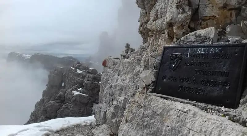
From Rifugio Alimonta, ascend a debris-filled gully to a fork: keep left toward the start of the Ferrata delle Bocchette Alte, overcoming a few short equipped sections, ledges, and rocky slabs. This brings you to the base of the ferrata, marked by a metal plaque next to a ladder (45 minutes from the refuge, 4h total). Enter the section dedicated to Umberto Quintavalle, characterized by a series of ladders that climb the northern side of Cima Molveno, then descend northwest to Bocca Bassa di Massodì (2790 m, 45 minutes from the start, 4h45' total). This passage, about ten meters long, is extremely exposed and often covered with snow or unstable scree; with less experienced companions, a short rope section for moving roped together can be useful. From here, you can descend along the Ferrata Oliva Detassis, which offers a possible escape route.
From Bocca Bassa begins the section dedicated to Mario Coggiola, leading to Bocca Alta di Massodì. It is a succession of ladders and very exposed but technically straightforward equipped sections, bringing you to the flat summit of Spallone di Massodì (2999 m). The descent from this point goes via the famous and demanding Scala degli Amici, a 30-meter metal ladder that is extremely steep and airy. After overcoming it, you face more easy equipped sections and ladders to Bocca Alta di Massodì (2950 m, 45 minutes from Bocca Bassa, 2h15' from Rifugio Alimonta).
The route continues climbing above 3000 meters, entering the section named after Maria Foresti. This sector is not characterized by vertical climbs, but by long, airy ledges traversed horizontally. Despite appearances, it demands maximum concentration due to the possible presence of snow-filled gullies. After these critical passages, climb a ladder to the Spalla Nord of Cima Brenta (1 hour from Bocca Alta). Then descend on an easy section, following the trail named after Carlo Garbari, a sequence of ladders and equipped steps leading to Bocca di Tucket (2648 m, 45 minutes from Spalla Nord, 5h from Rifugio Alimonta). From here, descend along a snowfield, where trekking poles are useful, then follow trail markers to Rifugio Tucket (2272 m, 30 minutes from Bocca di Tucket, 5h30' from Rifugio Alimonta).
The pace on the ferrata is a constant alternation of short but intense vertical climbs on ladders and long, sometimes nerve-wracking, horizontal traverses on ledges. The morphology is typically dolomitic, with solid rock often interrupted by debris-filled channels. The experience is deeply panoramic, with continuous views of the glacier and surrounding spires, but requires constant management of exposure and energy, given the overall length of the route.
Descent
From Rifugio Tucket begins the final descent to the starting point. Follow the long CAI 317 trail northwest, which is technically easy, passing first near Rifugio Casinei and then descending to Rifugio Vallesinella (1h30' from Rifugio Tucket, for a total of about 10 hours for the entire loop).
Useful Notes
The ferrata equipment is generally in good condition, with stable and well-built ladders, though not recently installed. The Garbari section can become particularly risky in snowy conditions; it is therefore strongly recommended to bring crampons and an ice axe in case the metal structures are unusable. The route is classified as difficult mainly due to the prolonged exposure and the presence of unprotected sections, such as Bocca Bassa di Massodì, while the technical difficulties are moderate. This is a long and physically demanding itinerary in a high-mountain environment, requiring good practice in moving on equipped sections with constant ups and downs. Given the great popularity of the Via Ferrate in the Dolomiti di Brenta, it is advisable to start very early in July and August to avoid crowds on the most exposed passages. A new suspension bridge, stable and well-built, has been installed in the south channel of Cima Brenta, improving safety by avoiding a section known for rockfall.
Track and weather
Plan the route
Preview the GPX track from the backend, download it for your GPS device, open parking directions, and check a short forecast before leaving.
Images
FAQ
What level of commitment does this via ferrata require?
ferrata.faqAnswers.commitment
How much elevation gain should I plan for?
The listed ferrata elevation gain is 438 m. Also consider approach, return and maximum altitude, because they can matter more than the equipped section alone.
Where is the route located?
Ferrata Bocchette Alte is located in Dolomiti di Brenta, Trento, Italy. Before leaving, check parking, access and current local conditions.
When is the best time to climb it?
The best season depends on altitude, aspect and lingering snow. Avoid storms, wet rock and uncertain conditions; start early and keep a margin for the return.
Gear and safety planning
Use the technical data on this page to plan equipment, timing and offline navigation. For a general checklist, read the equipment guide before opening the route in the app.
Video
Watch the route
Useful YouTube videos for getting a real feel for the route before you go.
Logbook
Route condition reports
Recent community notes about closures, snow, equipment damage, trail issues and current conditions.
Community
Reviews, check-ins and photos
-
0 reviews
2
2 climbers
10
Shared by the community
Community photos
Recent images uploaded by Sferrati members.
Reviews
Recent impressions from climbers who know the route.
No reviews yet
Be the first to review this via ferrata from the app.
Continue in the app
Track the climb, save maps offline, and sync this route to your personal profile.
Use the app to climb
Offline maps, tracking, saves, and profile sync.
Scan the code before leaving, install the app, and keep your route data ready when reception fades.
