
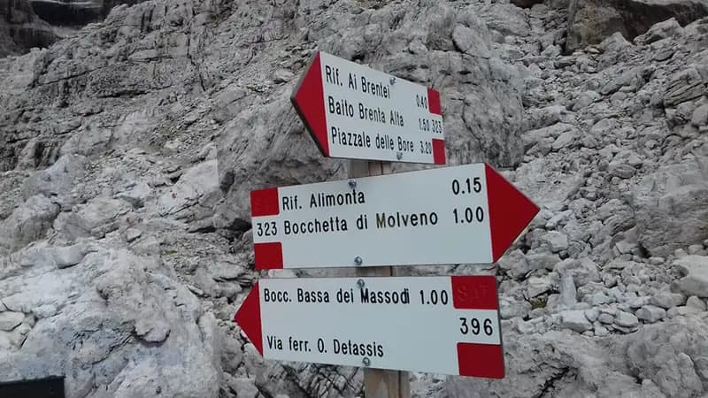
Ferrata Oliva Detassis
Dolomiti di Brenta · Trento · Italy
Technical data
- Difficulty
- Moderatamente Difficile
- Status
- aperta
- Distance
- 2 km
- Total duration
- 10 h
- Approach
- 3 h 15 min
- Ferrata time
- 1 h 15 min
- Elevation gain
- 110 m
- Max altitude
- 2807 m
Route planning
How to plan Ferrata Oliva Detassis
Ferrata Oliva Detassis is in Dolomiti di Brenta, Trento, Italy and is rated Moderatamente Difficile. Available route data lists about 10 h total time, 2 km of distance, 110 m of elevation gain.
For day planning, consider an approach of about 195 min, about 75 min on the cable, a maximum altitude near 2807 m. Reported route features include: Scale, Itinerario lungo.
The page includes a parking or driving-directions reference. A GPX track is not available yet, so bring an alternative map source.
As with every via ferrata, evaluate season, lingering snow, storms, crowds and equipment condition. Page last updated on 7/4/2026.
Features
Description
Overview
The Ferrata Oliva Detassis is a direct and challenging variant of a section of the Ferrata delle Bocchette Alte, deep in the heart of the Brenta Group. This route, characterized by exposed ladders and moderate difficulty, serves as a direct link between the Rifugio Alimonta and the Bocchetta Bassa di Massodì, offering a more vertical alternative to the classic passage via Bocca d'Armi. It is described here as part of a complete itinerary that, starting from the Rifugio Vallesinella, reaches the Bocchetta Bassa and then joins and continues north along the Bocchette Alte toward the Rifugio Tucket.
Approach
The recommended access begins at the Rifugio Vallesinella parking lot, above Madonna di Campiglio. From here, you ascend through dense forests toward the Rifugio Casinei (1850 m). Then take the CAI trail 318, which tackles the airy Galleria Bogani passage and leads to the Rifugio Brentei (2182 m), reachable in about 2 hours and 15 minutes of walking. From the Brentei, continue on the CAI trail 323, climbing northeast toward the Rifugio Alimonta. After about an hour, you encounter a crucial junction just before the hut: taking the left branch leads onto the CAI 396, which plunges into the wild Valle della Vedretta dei Brentei, heading toward the start of the via ferrata. The total approach time from the parking lot to the beginning of the equipped sections is about 3 hours and 15 minutes.
The approach route initially follows forest trails, then opens into the more alpine environments of the side valleys. The pace is steady and continuous, with a constant elevation gain that physically prepares you for the effort ahead. The setting is classic Dolomitic, with majestic walls looming over the ravines.
Via Ferrata
The CAI trail 396 traverses the wide and evocative Valle della Vedretta dei Brentei, aiming decisively toward the gully that descends from the Bocchetta Alta di Massodì. You cross some often snow-covered sections, staying on the right orographic side of the valley, until you reach the starting plaque of the Ferrata Oliva Detassis (about 20 minutes from the CAI 396 junction).
The actual ascent begins with a first ladder, followed by a series of metal stirrups. Then begins the characteristic and spectacular succession of vertical ladders, well-anchored and stable, which allow you to overcome the entire rock bastion for a height gain of over one hundred meters. These sections are extremely exposed, and for brief pauses or to clip in, it can be useful to use a quickdraw. The ladders are interspersed with short connecting sections and a few rocky ledges that offer dizzying views.
The via ferrata develops entirely on a compact wall of Dolomia Principale, offering continuous and physical climbing. The rhythm is set by the ladders: a vertical and unbroken progression that demands endurance and composure with exposure. Halfway up, you tackle a short ledge traverse that provides a moment of respite, before resuming with a final series of vertical ladders. The route culminates with a final traverse that emerges directly at the Bocca Bassa di Massodì (2790 m), where the Ferrata Detassis ends by merging into the Ferrata delle Bocchette Alte. The time to complete the via ferrata is about 45 minutes, for a total of 4 hours from the start of the hike.
Descent
Once at the Bocca Bassa di Massodì, within the described itinerary, two main options present themselves. The first is to continue north along the Ferrata delle Bocchette Alte toward the Rifugio Tucket (about 4 hours from the end of the Detassis). From the Rifugio Tucket, descend to the Rifugio Casinei via the CAI trail 317 and finally to the Rifugio Vallesinella (about 1 hour and 30 minutes from the Tucket), for a total hike time of about 10 hours. The second option is to turn south from the Bocchetta Bassa di Massodì, following the final section of the Bocchette Alte toward the Bocca Alta di Molveno, from where you descend to the right toward the Rifugio Alimonta and return via the approach route (about 3 hours and 30 minutes from the end of the Detassis, for a total of 8 hours). Alternatively, from the Bocca Alta di Molveno, you can descend toward the Rifugio Casinei via the Sentiero Attrezzato Violi, slightly lengthening the route.
The choice of descent route radically changes the character of the outing: continuing along the Bocchette Alte means undertaking a long high-altitude traverse, exposed and panoramic, while returning offers a more direct but still challenging itinerary.
Useful Notes
In the Brenta Group, it is common to encounter, even late in the season, snow-covered sections or permanent snowfields; it is therefore essential to be properly equipped (ice axe and crampons may be necessary) to tackle them safely. Wearing a helmet is strongly recommended already during the approach in the valley, due to the constant risk of falling rocks from the overhanging walls.
The passage at the Bocca Bassa di Massodì often represents the most critical point of the entire itinerary, due to its exposure and the frequent lack of protection on residual snow or ice; maximum caution is required at this point. The Ferrata Detassis presents no particular technical difficulties or climbing passages, being mainly composed of ladders, but it unfolds in a constantly exposed and airy environment that requires a good dose of composure and a head for heights.
For maps, the use of a detailed map of the Brenta Group is recommended. This itinerary lends itself perfectly to being combined with other classic Brenta routes, such as the Bocchette Centrali or the Ferrata Spellini, allowing you to create loop routes of varying length and difficulty, taking advantage of the efficient network of mountain huts.
Track and weather
Plan the route
Preview the GPX track from the backend, download it for your GPS device, open parking directions, and check a short forecast before leaving.
GPX track unavailable
This route does not include a downloadable track yet.
Images
FAQ
What level of commitment does this via ferrata require?
ferrata.faqAnswers.commitment
How much elevation gain should I plan for?
The listed ferrata elevation gain is 110 m. Also consider approach, return and maximum altitude, because they can matter more than the equipped section alone.
Where is the route located?
Ferrata Oliva Detassis is located in Dolomiti di Brenta, Trento, Italy. Before leaving, check parking, access and current local conditions.
When is the best time to climb it?
The best season depends on altitude, aspect and lingering snow. Avoid storms, wet rock and uncertain conditions; start early and keep a margin for the return.
Gear and safety planning
Use the technical data on this page to plan equipment, timing and offline navigation. For a general checklist, read the equipment guide before opening the route in the app.
Video
Watch the route
Useful YouTube videos for getting a real feel for the route before you go.
Logbook
Route condition reports
Recent community notes about closures, snow, equipment damage, trail issues and current conditions.
Community
Reviews, check-ins and photos
-
0 reviews
0
0 climbers
0
Shared by the community
Community photos
Recent images uploaded by Sferrati members.
No community photos yet
Open this route in the app to add the first photo.
Reviews
Recent impressions from climbers who know the route.
No reviews yet
Be the first to review this via ferrata from the app.
Continue in the app
Track the climb, save maps offline, and sync this route to your personal profile.
Use the app to climb
Offline maps, tracking, saves, and profile sync.
Scan the code before leaving, install the app, and keep your route data ready when reception fades.
