
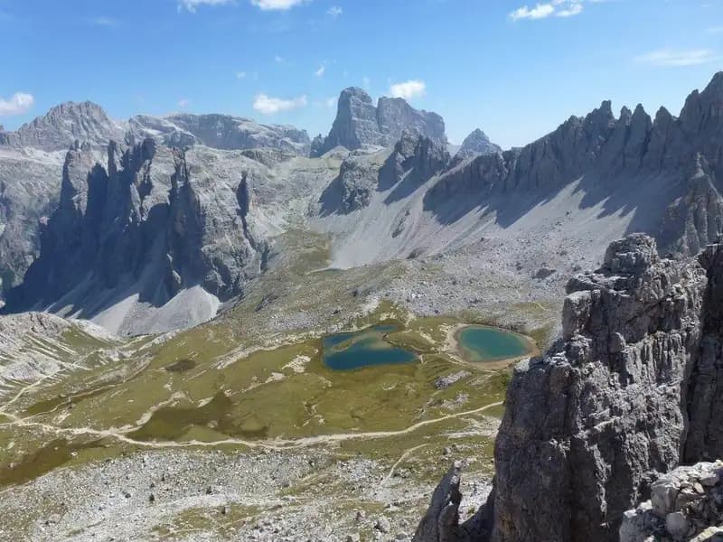
Ferrata delle Scalette Torre di Toblin
Torre di Toblin · Belluno · Italy
Technical data
- Difficulty
- Difficile
- Status
- aperta
- Distance
- 10,9 km
- Total duration
- 4 h
- Approach
- 1 h 30 min
- Ferrata time
- 45 min
- Elevation gain
- 317 m
- Max altitude
- 2617 m
Route planning
How to plan Ferrata delle Scalette Torre di Toblin
Ferrata delle Scalette Torre di Toblin is in Torre di Toblin, Belluno, Italy and is rated Difficile. Available route data lists about 4 h total time, 10,9 km of distance, 317 m of elevation gain.
For day planning, consider an approach of about 90 min, about 45 min on the cable, a maximum altitude near 2617 m. Reported route features include: Scale, Interesse Storico.
The page includes a parking or driving-directions reference. A GPX track is available to review and download.
As with every via ferrata, evaluate season, lingering snow, storms, crowds and equipment condition. Page last updated on 7/4/2026.
Features
Description
Overview
The Ferrata delle Scalette climbs the imposing northwest face of the Torre di Toblin in the Sexten Dolomites. It is a short but concentrated route, characterized by notable exposure and several technical moves that demand precision. The setting is visually stunning, with open views over the most famous Dolomite pinnacles. The route is commonly completed by descending the nearby Ferrata Hosp, creating a logical and highly appealing loop.
Approach
Access begins at the Rifugio Auronzo (2320 m), reachable by car from Misurina via a 7 km toll road. From here, follow the Sentiero 101, a comfortable and scenic path that leads to the Rifugio Lavaredo (2344 m) in about 30 minutes. Continue with a steeper gradient to Forcella Lavaredo (2454 m, 45 minutes total), a natural balcony overlooking Monte Paterno, the Sasso di Sesto, and the Torre di Toblin. Descending along Sentiero 101, keep straight, ignoring any left branches, and arrive at the Rifugio Locatelli (2450 m) in about 1 hour and 15 minutes from the start. From the hut, follow the red triangles northward, circling the Sasso di Sesto while skirting the left side of the Torre di Toblin; pass a World War I shelter and a distinctive metal cross. Red markings on the rock then guide you to the start of the route in about 20 minutes from the hut, for a total approach time of about 1 hour and 30 minutes.
Via Ferrata
From the markings, some red arrows direct you onto moderately difficult rock slabs, first left then right, up to a marble plaque that recalls the route's military origins. The ferrata begins immediately with determination in a well-equipped dihedral, moderately challenging but rich in holds. Turn right to ascend a stepped crack, exit left, and diagonally reach the first metal ladder. After crossing it, short steps lead to the first decidedly exposed section: climb a ridge next to an old wooden plank, then tackle two fully exposed ladders. The passage is not technically complex, but it marks the entry into the verticality of the environment. After the ladders, a ledge to the right passes under a rocky roof. This leads to the central and most characteristic section: a crack enters a long chimney equipped with ladders. The first two climb vertically, the third crosses the chimney perpendicularly, quite slanted, bringing you to the opposite side. A subsequent vertical section, not difficult, introduces the most challenging passage. To reach a ladder on the left side of the chimney, you must proceed in a stemming move (spaccata), as the left wall is smooth, often damp, and lacks footholds. The greatest effort is in the first two moves to hook onto the right side; then, carefully searching for holds, you gain the ladder. Exiting the chimney, traverse some slabs to the left and an exposed traverse with stirrups, with an exceptional view behind you. You find yourself at the base of the final chimney, ascended via numerous ladders. Two ladders climb within the crack, then you move left in full exposure for another ladder. The final sections involve climbing an exposed but well-holded ridge, a fold to the right, and a final ladder next to World War I remnants, leading to the summit plateau with the Summit Cross of the Torre di Toblin (2617 m). The time for the via ferrata is about 45 minutes, for a total of about 2 hours and 15 minutes from the parking lot.
Descent
From the summit, the recommended descent is along the Ferrata del Cappellano Hosp, also equipped (about 30 minutes from the summit, 2 hours and 45 minutes total). This option is preferable due to high traffic and because the Ferrata delle Scalette, with its three more challenging passages, is more logical as an ascent. Once back down, retrace the approach trail in reverse towards Rifugio Locatelli, Forcella Lavaredo, and finally Rifugio Auronzo. This return takes about 1 hour and 15 minutes from the end of the Ferrata Hosp (1 hour and 45 minutes from the summit), for a total hike duration of about 4 hours.
Useful Notes
Despite its brevity, the Ferrata delle Scalette alla Torre di Toblin should not be underestimated. Although it largely develops on metal ladders (medium-easy difficulty), it features three distinct passages that raise its difficulty: the initial dihedral, the stemming move in the chimney, and the final ridge. These, combined with the constant exposure, make it a difficult route for the average via ferrata enthusiast. For a fit hiker, the perceived difficulty will be moderate, but the combination of technical and environmental factors is significant. The setting of the Sexten Dolomites is magnificent and the ferrata is very popular. To avoid queues, it is advisable to tackle it early in the morning or late in the afternoon. Given the popularity of the area, consulting a detailed map, such as one dedicated to the Sexten Dolomites, is useful.
Track and weather
Plan the route
Preview the GPX track from the backend, download it for your GPS device, open parking directions, and check a short forecast before leaving.
Images
FAQ
What level of commitment does this via ferrata require?
ferrata.faqAnswers.commitment
How much elevation gain should I plan for?
The listed ferrata elevation gain is 317 m. Also consider approach, return and maximum altitude, because they can matter more than the equipped section alone.
Where is the route located?
Ferrata delle Scalette Torre di Toblin is located in Torre di Toblin, Belluno, Italy. Before leaving, check parking, access and current local conditions.
When is the best time to climb it?
The best season depends on altitude, aspect and lingering snow. Avoid storms, wet rock and uncertain conditions; start early and keep a margin for the return.
Gear and safety planning
Use the technical data on this page to plan equipment, timing and offline navigation. For a general checklist, read the equipment guide before opening the route in the app.
Video
Watch the route
Useful YouTube videos for getting a real feel for the route before you go.
Logbook
Route condition reports
Recent community notes about closures, snow, equipment damage, trail issues and current conditions.
Community
Reviews, check-ins and photos
-
0 reviews
0
0 climbers
0
Shared by the community
Community photos
Recent images uploaded by Sferrati members.
No community photos yet
Open this route in the app to add the first photo.
Reviews
Recent impressions from climbers who know the route.
No reviews yet
Be the first to review this via ferrata from the app.
Continue in the app
Track the climb, save maps offline, and sync this route to your personal profile.
Use the app to climb
Offline maps, tracking, saves, and profile sync.
Scan the code before leaving, install the app, and keep your route data ready when reception fades.
