
Technical data
- Difficulty
- Moderatamente Difficile
- Status
- aperta
- Distance
- 7,4 km
- Total duration
- 5 h
- Approach
- 1 h 30 min
- Ferrata time
- 45 min
- Elevation gain
- 123 m
- Max altitude
- 2240 m
Route planning
How to plan Ferrata Contin
Ferrata Contin is in Monte Cavallo, Udine, Italy and is rated Moderatamente Difficile. Available route data lists about 5 h total time, 7,4 km of distance, 123 m of elevation gain.
For day planning, consider an approach of about 90 min, about 45 min on the cable, a maximum altitude near 2240 m. Reported route features include: Ambiente naturale delle Alpi Carniche, Due opzioni di rientro, Percorso attrezzato di modeste difficoltà, Possibilità di deviare per la Torre di Winkel.
The page includes a parking or driving-directions reference. A GPX track is available to review and download.
As with every via ferrata, evaluate season, lingering snow, storms, crowds and equipment condition. Page last updated on 7/4/2026.
Features
Description
Overview
Dedicated to the memory of Enrico Contin, this via ferrata of medium-easy difficulty leads to the summit of Monte Cavallo, situated on the Italian-Austrian border near the Passo di Pramollo in the Carnic Alps. The route unfolds in a particularly evocative setting, characterized by sweeping panoramas and rugged terrain. The loop itinerary offers two distinct descent options: the more direct route down the normal Austrian route or the more challenging and scenic variant that follows the ridge of the Alta Via CAI Pontebbia. The ferrata can also be used as a descent alternative for those who have tackled the more technical Ferrata alla Torre Clampil.
Approach
The starting point is a short distance from the Passo di Pramollo, on the Italian side. The parking area (1568 m) is located next to a disused white barracks, near the second-to-last hairpin turn before the pass. From Pontebba, reach the spot by following signs for the pass for about 12 km (20 minutes by car).
From the parking area, take trail 433, which winds through the forest with an undulating profile, leading in about one kilometer to the colorful Baita Winkel (1470 m), after crossing a small bridge over the Rio Winkel. The pace is pleasant and steady. Continue on trail 433, ignoring the left junction for the Alta Via CAI Pontebbia towards Sella della Pridola (which will serve as one of the descent options). The trail, alternating between wooded sections and clearings, gradually climbs toward the walls that close off the valley. The character is hiking-level and free of difficulty. After passing the left turn-off for the Sentiero Alpinistico Schiavi, ascend the valley to a crucial junction, well-marked by a CAI sign and rock cairns:
- To the right: start of the Ferrata alla Torre Clampil.
- To the left: start of the Ferrata Contin.
Take the left, with the imposing mass of Monte Cavallo always in sight. The final stretch involves ascending a scree slope at the base of the Torre Winkel, until reaching the start of the cables on the Ferrata Contin. The approach takes about 1 hour and 30 minutes from the parking area.
Via Ferrata
The equipped route begins with the ascent of a steep but well-structured gully, developing mainly along its left side. The first meters feature natural steps and moderate steepness; then the line swings decisively to the left, becoming more vertical, with sequences of small rock bands and short ledges that present no significant technical difficulty. The rock, of limestone-dolomite nature, offers good grip. You emerge onto a grassy saddle where the cables temporarily end. From this point, a deviation to the right (with three more demanding equipped passages) leads to the summit of the Torre di Winkel.
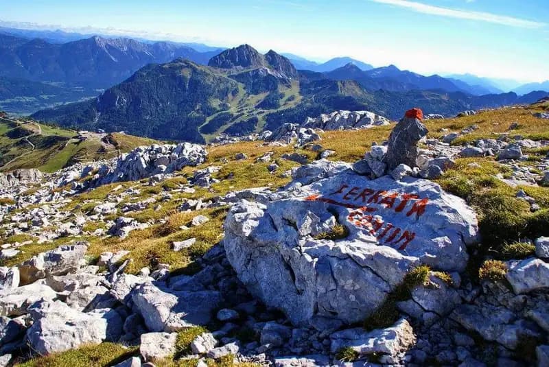
For the direct route to Monte Cavallo, instead continue along the trail, following the path and cairns, until you find the cables again. The route alternates easy trail sections with short equipped stretches, where lateral exposure or steepness requires the use of the cables. The overall commitment remains moderate. Finally, you reach the summit meadows, a broad grassy ridge. Following the red paint marks on the rocks, you arrive at the summit of Monte Cavallo (2240 m), marked by a border stone and a bell. The climbing time from the start of the ferrata is about 1 hour (total from the car: 2 hours and 30 minutes). The character of the route is predominantly vertical in the first part, then becomes more mixed and panoramic near the summit.
Descent
From the summit of Monte Cavallo, there are two loop descent options.
The first option, recommended for experienced hikers with a steady step on varied terrain, follows the ridge of the Alta Via CAI Pontebbia to the southeast. This trail, marked by sometimes faded orange-and-blue blazes, runs along an articulated crest, alternating broad sections with more demanding passages. It includes short climbing sections (maximum grade II) and exposed traverses, developing on solid rock but with some steep, scree-filled descent gullies. The environment is wild and of great scenic beauty. In about 1 hour and 30 minutes, you reach the Sella della Pridola (1644 m). After a final challenging gully, descend left to reach the Baita Winkel in another 15 minutes. From here, return to the parking area via the approach trail. The full descent from the summit takes about 2 hours and 15 minutes (total hike duration: about 5 hours). This route requires good terrain assessment skills and a certain agility.
The second alternative descends via the normal Austrian route, which is more straightforward and frequented, first reaching a small lake, then the Passo di Madrizze, and finally the Baita Winkel in about 2 hours from the summit. From there, return to the parking area via the ascent route. The total descent with this option is about 2 hours and 30 minutes from the summit (total hike duration: about 5 hours). It is the best choice for those who prefer a more direct and less technical route.
Useful Notes
The Ferrata Contin is classified as medium-easy, with no technically complex passages. The rock is generally solid and well-stepped. Watch out for mixed sections of rock and grass, which can become slippery in damp conditions. The descent option along the Alta Via CAI Pontebbia requires a steady foot, no fear of heights, and at least minimal climbing experience (maximum grade II). The route, inaugurated by the CAI Pontebba on August 17, 1969, was completely renovated in 2001. The area offers other interesting via ferratas such as the Ferrata delle Crete Rosse, the Ferrata Uiberlacher, and the Ferrata Senza Confini.
Track and weather
Plan the route
Preview the GPX track from the backend, download it for your GPS device, open parking directions, and check a short forecast before leaving.
Images
FAQ
What level of commitment does this via ferrata require?
ferrata.faqAnswers.commitment
How much elevation gain should I plan for?
The listed ferrata elevation gain is 123 m. Also consider approach, return and maximum altitude, because they can matter more than the equipped section alone.
Where is the route located?
Ferrata Contin is located in Monte Cavallo, Udine, Italy. Before leaving, check parking, access and current local conditions.
When is the best time to climb it?
The best season depends on altitude, aspect and lingering snow. Avoid storms, wet rock and uncertain conditions; start early and keep a margin for the return.
Gear and safety planning
Use the technical data on this page to plan equipment, timing and offline navigation. For a general checklist, read the equipment guide before opening the route in the app.
Video
Watch the route
Useful YouTube videos for getting a real feel for the route before you go.
Logbook
Route condition reports
Recent community notes about closures, snow, equipment damage, trail issues and current conditions.
Community
Reviews, check-ins and photos
-
0 reviews
0
0 climbers
0
Shared by the community
Community photos
Recent images uploaded by Sferrati members.
No community photos yet
Open this route in the app to add the first photo.
Reviews
Recent impressions from climbers who know the route.
No reviews yet
Be the first to review this via ferrata from the app.
Continue in the app
Track the climb, save maps offline, and sync this route to your personal profile.
Use the app to climb
Offline maps, tracking, saves, and profile sync.
Scan the code before leaving, install the app, and keep your route data ready when reception fades.
