
Sentiero Attrezzato Leva
Cima di Terrarossa · Udine · Italy
Technical data
- Difficulty
- Moderatamente Difficile
- Status
- aperta
- Distance
- 9,1 km
- Total duration
- 5 h
- Approach
- 2 h
- Ferrata time
- 1 h 30 min
- Elevation gain
- 178 m
- Max altitude
- 2420 m
Route planning
How to plan Sentiero Attrezzato Leva
Sentiero Attrezzato Leva is in Cima di Terrarossa, Udine, Italy and is rated Moderatamente Difficile. Available route data lists about 5 h total time, 9,1 km of distance, 178 m of elevation gain.
For day planning, consider an approach of about 120 min, about 90 min on the cable, a maximum altitude near 2420 m. Reported route features include: Scale, Itinerario lungo, Itinerario Alpinistico.
The page includes a parking or driving-directions reference. A GPX track is available to review and download.
As with every via ferrata, evaluate season, lingering snow, storms, crowds and equipment condition. Page last updated on 7/4/2026.
Features
Description
Overview
The Sentiero Attrezzato Augusto ed Elenita Leva is a medium-difficulty loop that connects Cima di Terrarossa with Forca dei Disteis, in the Jof di Montasio group. Starting from the Montasio Plateau, the route runs mostly along long ledges, offering continuous views of the northern faces of the Julian Alps. The traverse is characterized by numerous exposed and unprotected sections, demanding constant attention and surefootedness.
Approach
The starting point is the parking lot on the Montasio Plateau (1500 m), reachable from Sella Nevea. From Chiusaforte, about twenty minutes from the Carnia-Tolmezzo exit of the A23, follow signs for Sella Nevea and, after passing the town, those for the Montasio Plateau until the road ends.
From the parking lot, take a gently rising dirt road that leads to the Rifugio Brazzà (1660 m) in thirty minutes. Continuing on the well-marked trail toward the rock walls, you reach a junction. Keep right, following signs for the Sentiero Attrezzato Leva and the Sentiero Attrezzato Ceria Merlone, ignoring the left fork for Jof di Montasio. The ascent proceeds first through meadows, then over scree and talus slopes, heading toward the steep flanks of Cima di Terrarossa. The landscape is open and grows progressively more severe, with the mountain's profile dominating the horizon. After one hour and fifteen minutes from the rifugio (for a total of one hour and forty-five minutes from the start), you arrive at a junction at 2285 meters: right continues toward Ceria Merlone, left climbs to the summit. Taking the left, in another fifteen minutes you gain the Cima di Terrarossa (2420 m), where the via ferrata proper begins. This approach, though a hiking trail, prepares you physically and mentally for the more technical terrain ahead.
Via Ferrata
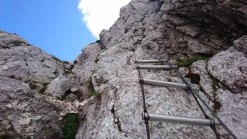
From the summit, the first objective is the descent toward Forca del Pallone. The initial section is a trail with no technical difficulty, leading to a singular metal ladder propped against the rock, which must be descended carefully. You then emerge onto an equipped ledge that, skirting the west side of Cima di Terrarossa, reaches Forca del Pallone (2242 m) in about twenty minutes from the summit. From here, you get your first full view of the route: an impressive sequence of ledges cutting across the opposite wall of the gorge, hinting at the predominantly horizontal but exposed nature of the traverse.
Crossing the notch, the most technical section of the entire route begins. After a short ledge, you must gain elevation to reach a higher ledge, tackling the ascent of a couple of vertical walls and a narrow chimney. This passage, recently re-equipped with numerous metal anchors, is the only truly vertical section of the ferrata. The rock is solid and holds are frequent, but the progression is physically demanding. Once past the wall, you arrive at a ledge offering a breathtaking view of the Montasio Plateau and, behind you, Cima di Terrarossa.
Exiting the recess of the notch, the longest and most spectacular part of the traverse begins: a succession of ledges of varying width, not always equipped, that cut across the face. The rhythm becomes undulating, with a continuous alternation of flat sections, short ups and downs, passages under rock roofs, and very exposed stretches. The route unfolds on limestone, shaped into ledges that are sometimes wide, sometimes so narrow they demand concentration and precision in movement. The environment is wild and remote; it's not uncommon to encounter herds of ibex. During the progression, your gaze constantly sweeps over the majestic Jof di Montasio and, as you near the end, you catch sight of the Scala di Pipan of the normal route. The via ferrata ends at a small metal plaque at about 2400 meters, roughly one hour and thirty minutes from Cima di Terrarossa. This section is more an exposed traverse than a classic ferrata, where the main challenge is psychological, stemming from continuous exposure and the length of unprotected sections.
Descent
A few meters above the arrival junction, you can see the start of the Scala di Pipan. For the descent, instead continue on the trail that leads westward without difficulty to Forca dei Disteis (2201 m). Here, ignoring the Grande Gengia trail to the right, keep left and begin a steady, steep descent toward the plateau. The path cuts diagonally across vast meadows and debris slopes, offering a stark contrast to the rocky environment just left behind. Following the well-defined track, you once again reach the Rifugio Brazzà. From there, retrace the approach trail back to the parking lot. The descent takes about one hour and thirty minutes from the end of the ferrata, for a total time of roughly five hours. It's a fast but knee-punishing descent that closes the loop, returning you to a more domesticated setting.
Useful Notes
The main difficulties of this Sentiero Attrezzato Leva lie in the numerous exposed passages on ledges, often lacking fixed protection. The route's character is more that of an alpine traverse than a traditional via ferrata, requiring good balance and a head for heights. The equipped sections, while highly scenic and adrenaline-filled, present no great technical difficulties except for the short vertical passage. The most challenging section is the initial one near Forca del Pallone, with the ascent of the chimney and vertical walls. The itinerary is described in the recommended direction (from Terrarossa toward Forca dei Disteis) to tackle the most vertical part on the ascent, making it safer. It is possible to combine this route, if done in reverse, with the nearby Sentiero Attrezzato Ceria Merlone, creating a longer and more demanding loop. The Montasio Plateau area offers numerous other alpine opportunities, such as the Ferrata Amalia for climbing Jof di Montasio, or the via ferratas on the Canin, Jof Fuart, and Mangart groups.
Track and weather
Plan the route
Preview the GPX track from the backend, download it for your GPS device, open parking directions, and check a short forecast before leaving.
Images
FAQ
What level of commitment does this via ferrata require?
ferrata.faqAnswers.commitment
How much elevation gain should I plan for?
The listed ferrata elevation gain is 178 m. Also consider approach, return and maximum altitude, because they can matter more than the equipped section alone.
Where is the route located?
Sentiero Attrezzato Leva is located in Cima di Terrarossa, Udine, Italy. Before leaving, check parking, access and current local conditions.
When is the best time to climb it?
The best season depends on altitude, aspect and lingering snow. Avoid storms, wet rock and uncertain conditions; start early and keep a margin for the return.
Gear and safety planning
Use the technical data on this page to plan equipment, timing and offline navigation. For a general checklist, read the equipment guide before opening the route in the app.
Video
Watch the route
Useful YouTube videos for getting a real feel for the route before you go.
Logbook
Route condition reports
Recent community notes about closures, snow, equipment damage, trail issues and current conditions.
Community
Reviews, check-ins and photos
-
0 reviews
0
0 climbers
0
Shared by the community
Community photos
Recent images uploaded by Sferrati members.
No community photos yet
Open this route in the app to add the first photo.
Reviews
Recent impressions from climbers who know the route.
No reviews yet
Be the first to review this via ferrata from the app.
Continue in the app
Track the climb, save maps offline, and sync this route to your personal profile.
Use the app to climb
Offline maps, tracking, saves, and profile sync.
Scan the code before leaving, install the app, and keep your route data ready when reception fades.
