
Ferrata del Centenario al Monte Grona
Monte Grona · Como · Italy
Technical data
- Difficulty
- Difficile
- Status
- aperta
- Distance
- 8,1 km
- Total duration
- 5 h 45 min
- Approach
- 1 h 15 min
- Ferrata time
- 2 h 45 min
- Elevation gain
- 385 m
- Max altitude
- 1736 m
Route planning
How to plan Ferrata del Centenario al Monte Grona
Ferrata del Centenario al Monte Grona is in Monte Grona, Como, Italy and is rated Difficile. Available route data lists about 5 h 45 min total time, 8,1 km of distance, 385 m of elevation gain.
For day planning, consider an approach of about 75 min, about 165 min on the cable, a maximum altitude near 1736 m.
The page includes a parking or driving-directions reference. A GPX track is available to review and download.
As with every via ferrata, evaluate season, lingering snow, storms, crowds and equipment condition. Page last updated on 7/4/2026.
Description
Overview
The Ferrata del Centenario CAO Como is a demanding alpine route suitable only for experienced hikers with excellent physical fitness and technical ability. The climb progresses over generally excellent quality rock that is solid and rich in natural holds, encouraging active climbing. The route is defined by a strong and continuous exposure, a dominant element that accompanies the hiker for nearly its entire length, shaping both its technical character and psychological demands.
Approach
The starting point is the locality of Monti di Breglia, in the province of Como. Once you reach Breglia, turn left just before the village following a brown sign. The road, initially paved but rough, becomes a dirt track before returning to pavement. At a hairpin bend to the right, a sign with a "P" marks a large open area on the left that can be used for parking. Access to the road is regulated by a 3 Euro ticket, payable at a machine on site.
From the hairpin, a dirt trail departs with signs for Monte Grona and Rifugio Menaggio. After a few meters you reach a junction: the right-hand path, higher and more panoramic, is slightly more challenging and takes about 45 minutes to reach the refuge; the left-hand one, easier, requires about an hour. The right-hand route is recommended, as it leads without technical difficulty to Rifugio Menaggio. During the ascent you encounter a second junction where you keep left, always following signs for the refuge.
From the refuge, continue along the marked trail heading southwest until you reach a white sign indicating the start of the Ferrata del Centenario CAO Como for Monte Grona. The approach from the parking area takes about 1 hour and 15 minutes.
Via Ferrata
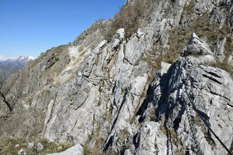
The route winds along a rocky crest composed of a succession of rock towers, or "teeth." The typical equipment of Lombard via ferratas is present: a steel cable and a chain, which sometimes cross or diverge, requiring careful management of your carabiners even in the absence of anchor bolts.
The first tower attacks immediately with a very steep climb, developing diagonally to the left on fractured rock rich in holds. Watch out for a short polished traverse where the lack of footholds makes using the chain essential. The progression, vertical with deviations to the right and left to overcome rocky steps, offers notable exposure right from the start. You reach a horizontal traverse to the left, followed by a smoother vertical wall. You then arrive at a challenging rock chimney, where the cable (on the right) and chain (on the left) follow separate lines; on the left side there are useful foot stirrups. Once past the chimney, the aids rejoin and you climb a short wall, rounding its summit to the left.
After a horizontal section, you climb a few meters up the next ridge on its left side. You then tackle an airy crest traverse to the left, which leads beneath another fine vertical slab to be climbed. Continue climbing leftward, following a difficult traverse that is first horizontal and then diagonal, rounding a ridge. Then climb a more slabby wall, concluding the first tower with a short descent. Near the second tower, a sign marks the first escape route, while the continuation of the route lies straight ahead.
The second tower, shorter than the first, immediately presents a tricky, overhanging passage in a rocky notch, aided by a stirrup on the left. Once past this point, climb a long pillar on excellent, very climbable rock, then traverse left, ascending a series of slabby rocks, approaching the third tower.
The third tower is more polished, and the first meters are particularly physical, with reduced holds making the chain more necessary. Traverse to the left (with the help of some stirrups) to an exposed and thrilling passage: you must proceed in a straddle position inside a crack to reach the other side of the rock, with strong exposure. Beyond this section, climb another 4-5 demanding meters and traverse right toward a prominent ridge to be climbed, still in strong exposure. Once this tower is finished, you prepare for the fourth, where you encounter a final escape route.
The fourth and final tower begins with a smooth and difficult slab, even harder than the previous one, offering few holds and only a couple of small ledges to catch your breath. Traverse to the right, climb a ridge, and finally a challenging crack, completing the tower.
The final section involves a short vertical climb on a slab, a slightly overhanging traverse, and one last slab, before reaching via a short equipped path the longed-for summit cross of Monte Grona, with a beautiful panorama over Lake Como. The climbing time from the start of the via ferrata is about 2 hours and 45 minutes, for a total of about 4 hours from the parking area.
Descent
From the summit of Monte Grona you have two options. The Normal Route descends without particular difficulty: a short equipped section leads to the junction with the Direttissima; climb back toward the north anticima of Grona and follow the trail that descends among the rocks of the northern slope to the Sella della Forcoletta, then descend to Rifugio Menaggio and from there, retracing your steps, to the parking area (about 1 hour and 45 minutes from the summit, total 5 hours and 45 minutes).
Alternatively, from the summit descend the equipped section and take the channel of the Direttissima to the right, a steeper and more airy route than the Normal Route, with some easy equipped passages, which leads back to the refuge and then to the parking area (about 1 hour and 30 minutes from the summit, total 5 hours and 30 minutes).
Useful Notes
The Ferrata del Centenario CAO Como is very climbable but long and overall tiring; proper use of your arms is essential to avoid getting into difficulty on the crucial passages of the third and fourth towers. Managing your carabiners requires attention where the chain and cable cross or separate. The escape routes present along the itinerary are psychologically important in case of need.
The Lake Como area offers other opportunities for via ferratas on the same day: not far from the parking area you'll find the Ferrata dei Picasass to the south and the Biasini or Succetti via ferratas to the north. Moving toward the Larian Triangle, you can tackle the challenging via ferratas of Sass Tavaracc, Corno Rat, and Corno Occidentale di Canzo. Toward the province of Varese, you can do the Ferrata Belotti near Mesenzana.
Track and weather
Plan the route
Preview the GPX track from the backend, download it for your GPS device, open parking directions, and check a short forecast before leaving.
Images
FAQ
What level of commitment does this via ferrata require?
ferrata.faqAnswers.commitment
How much elevation gain should I plan for?
The listed ferrata elevation gain is 385 m. Also consider approach, return and maximum altitude, because they can matter more than the equipped section alone.
Where is the route located?
Ferrata del Centenario al Monte Grona is located in Monte Grona, Como, Italy. Before leaving, check parking, access and current local conditions.
When is the best time to climb it?
The best season depends on altitude, aspect and lingering snow. Avoid storms, wet rock and uncertain conditions; start early and keep a margin for the return.
Gear and safety planning
Use the technical data on this page to plan equipment, timing and offline navigation. For a general checklist, read the equipment guide before opening the route in the app.
Video
Watch the route
Useful YouTube videos for getting a real feel for the route before you go.
Logbook
Route condition reports
Recent community notes about closures, snow, equipment damage, trail issues and current conditions.
Community
Reviews, check-ins and photos
-
0 reviews
0
0 climbers
0
Shared by the community
Community photos
Recent images uploaded by Sferrati members.
No community photos yet
Open this route in the app to add the first photo.
Reviews
Recent impressions from climbers who know the route.
No reviews yet
Be the first to review this via ferrata from the app.
Continue in the app
Track the climb, save maps offline, and sync this route to your personal profile.
Use the app to climb
Offline maps, tracking, saves, and profile sync.
Scan the code before leaving, install the app, and keep your route data ready when reception fades.
