
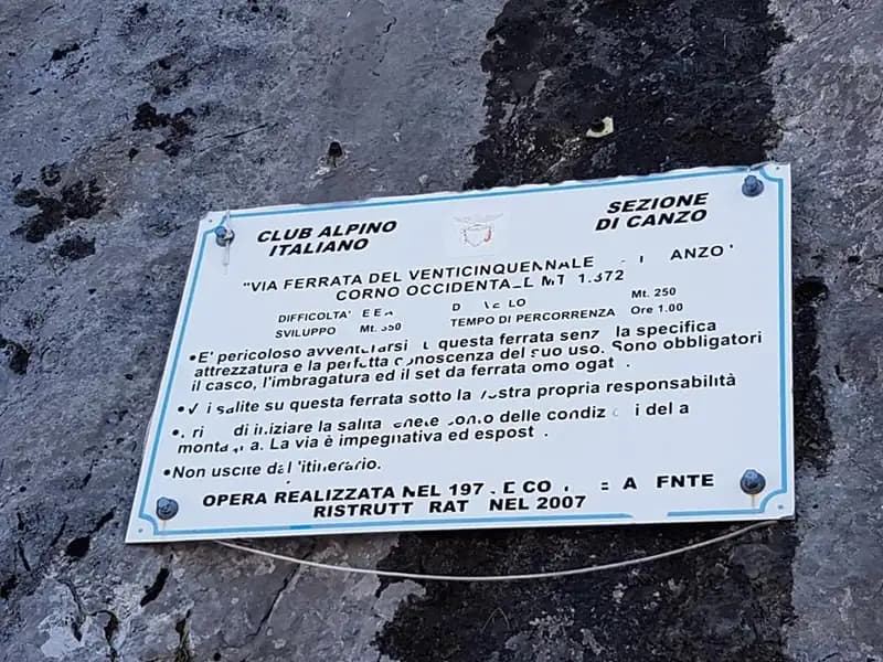
Technical data
- Difficulty
- Difficile
- Status
- aperta
- Distance
- 11 km
- Total duration
- 4 h 45 min
- Approach
- 1 h 45 min
- Ferrata time
- 1 h 30 min
- Elevation gain
- 250 m
- Max altitude
- 1373 m
Route planning
How to plan Ferrata del Venticinquennale
Ferrata del Venticinquennale is in Corno Occidentale, Como, Italy and is rated Difficile. Available route data lists about 4 h 45 min total time, 11 km of distance, 250 m of elevation gain.
For day planning, consider an approach of about 105 min, about 90 min on the cable, a maximum altitude near 1373 m. Reported route features include: Scale.
The page includes a parking or driving-directions reference. A GPX track is available to review and download.
As with every via ferrata, evaluate season, lingering snow, storms, crowds and equipment condition. Page last updated on 7/4/2026.
Features
Description
Overview
The Ferrata del Venticinquennale is a technically demanding route that climbs the southwest face of the Corno Occidentale di Canzo. Its difficulty is compounded by a long approach and sustained climbing on compact rock where the artificial anchors are widely spaced. For safe and efficient progress, a solid rock-climbing technique is essential-you need to move on your feet and use the cable as protection rather than a constant hand-over-hand aid, preserving your arm strength for when it truly counts.
Approach
Access to the route starts from the Sorgenti di Gajum in Canzo (CO). From here, follow the paved road uphill to a large parking area. The actual approach to the via ferrata involves climbing to the Rifugio Terz'Alpe, which can be reached via two trails: the path that follows the Ravella stream or the route passing through Prim'Alpe and Second'Alpe. From the rifugio, continue north onto a steep forest trail heading toward the Colma di Pianezzo. Just before reaching the summit cross, a clear path branches off to the right, crosses a scree slope, and leads to the start of the ferrata. The total approach time is about 1 hour and 45 minutes from the Gajum parking area.
Via Ferrata
The route begins with a short slab of moderate angle, angling diagonally left across a face rich in natural holds and edges. This initial section, while not overly steep, sets the tone for the compact limestone terrain that defines the entire climb. You then reach the base of a long, demanding smooth slab, now partially equipped with a few anchors that, combined with the rock's texture, aid progression. It is on this first big wall that the route's rhythm is established: the need to climb actively, using every tiny foothold, is absolute-avoid early and exhausting continuous pulling on the cable.
After overcoming the main slab, the line veers right, ascending diagonally up a initially narrow gully, aided by two metal stirrups. After rounding a tree rooted in the crack, you enter a long horizontal traverse to the right. This passage, developed along a natural ledge, offers good footholds but less generous and sometimes distant handholds, requiring careful body balance and judicious use of the sturdy protection chain. Be careful not to linger on the short, slightly overhanging sections, to avoid unnecessarily tiring your arms.
Once the traverse is complete, you tackle a technical dihedral where finding the best jams and holds becomes crucial. The angle eases briefly over pleasant, well-holded rock before resuming on a more vertical face rich in texture. You then encounter a metal ladder about twenty meters long, which overcomes a short overhang. Beyond the ladder, after climbing a depression and some rocky steps with small anchors, you reach a short equipped trail on a ledge-an ideal spot for a rest before the final section.
The last pillar is the technical climax of the route, demanding good climbing technique to overcome a few smooth slabs, despite the presence of a few stirrups. The ferrata ends on a rocky terrace. Following red paint marks to the right and uphill, you cross a saddle and finally ascend to the summit of the Corno Occidentale. The climbing time for the via ferrata is about 1 hour and 30 minutes, for a total of 3 hours from the start of the approach.
Descent
Two options are available for the return. The first descends from the summit to the north, following red marks down a steep gully with short Grade I sections; caution-the ground can become very slippery if the rock is wet. Reaching the saddle between the two Corni, continue north to the Rifugio Pianezzo, from where signs lead back to Gajum (about 1h 45' from the end of the ferrata, for a total of 4h 45' from the start).
The second option, to avoid the steeper, more technical gully, involves returning to the saddle just after the end of the ferrata and following trail markers along the ridge until you find a less demanding, more open gully. This descent variant leads near the cross encountered on the approach, then quickly reaches the Rifugio Pianezzo and the trail to Gajum (about 2 hours from the end of the ferrata, for a total of 5 hours).
Useful Notes
The Ferrata del Venticinquennale is a technically selective route and not suitable for beginners, given the high proportion of free climbing on often smooth rock. Protection is frequently provided by a large-diameter chain, which can sometimes prevent smooth carabiner sliding; it is advisable to clip into the steel cable where available, reserving the chain for pulling or resting phases.
A note of caution concerns the Passo della Vacca, the short but exposed ridge crossing encountered after the ferrata on the way to the summit. While it presents no major technical difficulties, it should absolutely not be underestimated, especially due to the tendency for concentration to wane after the sustained effort of the equipped route.
Logistically, this ferrata is located near the Ferrata del 30° OSA al Corno Rat. Although it is theoretically possible to do both in the same day starting from Valmadrera (LC), each is individually very demanding and requires careful assessment of your physical and technical condition.
Track and weather
Plan the route
Preview the GPX track from the backend, download it for your GPS device, open parking directions, and check a short forecast before leaving.
Images
FAQ
What level of commitment does this via ferrata require?
ferrata.faqAnswers.commitment
How much elevation gain should I plan for?
The listed ferrata elevation gain is 250 m. Also consider approach, return and maximum altitude, because they can matter more than the equipped section alone.
Where is the route located?
Ferrata del Venticinquennale is located in Corno Occidentale, Como, Italy. Before leaving, check parking, access and current local conditions.
When is the best time to climb it?
The best season depends on altitude, aspect and lingering snow. Avoid storms, wet rock and uncertain conditions; start early and keep a margin for the return.
Gear and safety planning
Use the technical data on this page to plan equipment, timing and offline navigation. For a general checklist, read the equipment guide before opening the route in the app.
Video
Watch the route
Useful YouTube videos for getting a real feel for the route before you go.
Logbook
Route condition reports
Recent community notes about closures, snow, equipment damage, trail issues and current conditions.
Community
Reviews, check-ins and photos
-
0 reviews
0
0 climbers
4
Shared by the community
Community photos
Recent images uploaded by Sferrati members.
Reviews
Recent impressions from climbers who know the route.
No reviews yet
Be the first to review this via ferrata from the app.
Continue in the app
Track the climb, save maps offline, and sync this route to your personal profile.
Use the app to climb
Offline maps, tracking, saves, and profile sync.
Scan the code before leaving, install the app, and keep your route data ready when reception fades.
