
Ferrata del Monte Emilius (Col Ros)
Monte Emilius · Aosta · Italy
Technical data
- Difficulty
- Difficile
- Status
- aperta
- Distance
- 11 km
- Total duration
- 11 h
- Approach
- 3 h 30 min
- Ferrata time
- 3 h
- Elevation gain
- 400 m
- Max altitude
- 3357 m
Route planning
How to plan Ferrata del Monte Emilius (Col Ros)
Ferrata del Monte Emilius (Col Ros) is in Monte Emilius, Aosta, Italy and is rated Difficile. Available route data lists about 11 h total time, 11 km of distance, 400 m of elevation gain.
For day planning, consider an approach of about 210 min, about 180 min on the cable, a maximum altitude near 3357 m. Reported route features include: Alta montagna, Itinerario lungo, Funivia all'andata, Funivia al ritorno.
The page includes a parking or driving-directions reference. A GPX track is available to review and download.
As with every via ferrata, evaluate season, lingering snow, storms, crowds and equipment condition. Page last updated on 7/4/2026.
Features
Description
Overview
This route describes the new via ferrata, inaugurated in 2022, which leads from Col Ross to the summit of Monte Emilius. The route initially runs independently from the historic ferrata, then joins it near Monte Rosso and continues as one to the summit. The return is via the normal route. This is a very long and demanding itinerary, both for the considerable accumulated elevation gain and the alpine environment that exceeds 3,500 meters in altitude. While the technical difficulty features some challenging passages, it remains predominantly at a moderate level. The overall length and the severe high-altitude setting make this ascent suitable only for experienced hikers in excellent physical condition.
The route is characterized by a sustained, continuous pace with few natural resting spots. Exposure is often pronounced, especially on the ridge sections and the open slopes of the southwestern side. The progression alternates between vertical climbs on slabs and chimneys and horizontal traverses on ledges, offering varied and never monotonous movement. The environment is dominated by micaschist and gneiss rock, typical of the massif's crystalline basement, forming sharp ridges and broad scree slopes.
Approach
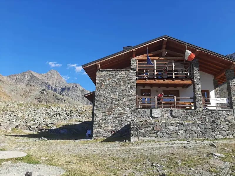
The logical starting point is the top station of the cable car connecting Aosta to Pila, specifically at the Chamolè station. It is also possible to start directly from Pila. From the Chamolè station, at about 2,300 meters, take the marked trail heading toward Rifugio Arbolle. Follow the trail markers 19c and then 19a, climbing toward Col de Chamolè before descending about a hundred meters into the Arbolle valley, with a beautiful view of Lago d'Arbolle. This approach section takes about one hour and thirty minutes, reaching approximately 2,500 meters at the refuge, where an overnight stay is also possible.
From Rifugio Arbolle, continue on trail 14, the normal route to Monte Emilius, heading east. After about thirty minutes, you'll encounter a junction on the left, well-marked for the ferrata, where yellow paint marks also begin. The track enters the Vallone d'Arbolle, becoming more defined, and starts climbing a scree field followed by a steep ramp directly toward Col Ross. This second part of the approach from the refuge takes about two hours, for a total of roughly three hours and thirty minutes from the top cable car station, reaching the approximately 3,100 meters of Col Ross.
The approach is a hike in its own right, gradually introducing the high-altitude environment. The trail first winds through pastures and moraines, then climbs steep scree ramps at the base of the Monte Rosso walls. The pace is steady, with sustained elevation gain that physically prepares you for the subsequent progression on the cables. Arriving at Col Ross marks entry into a severe environment, dominated by the void of the valley and the imposing rock structures of Emilius's southwestern ridge.
Via Ferrata
The new Ferrata del Monte Emilius represents a variation on the historic route that started from Col Carrel. The two meet and merge at Monte Rosso, sharing the same equipped route from there to the summit. The technical details of the climb along the cables are being prepared. Overall, the progression along the via ferrata to the summit of Monte Emilius, at 3,357 meters, takes about three hours. Adding the approach time, reaching the summit takes about six hours and thirty minutes from the cable car departure.
The ferrata develops mainly along the southwestern ridge, offering a technical but fluid progression. The first sections from Col Ross are vertical and physical, with passages on smooth slabs and gullies, then opening into long, airy traverses on ledges and ribs. The equipment is continuous and well-anchored in solid crystalline rock, allowing safe progression despite constant exposure. The route's character is distinctly panoramic, with continuous views of the Aosta Valley and the Gran Paradiso massif. The junction with the historic route at Monte Rosso occurs on a broad ridge section, before the final, more demanding push to the summit.
Descent
From the summit, descend via the normal route over scree slopes toward Passo dei Tre Cappuccini. Then skirt the striking Lago Gelato and continue the descent until you again reach Rifugio Arbolle. This return section from the summit to the refuge takes about two hours and thirty minutes, bringing the total hike time to around ten hours. From the Arbolle, finally return via the trail already taken on the ascent toward the cable car station, with a final hour of walking bringing the total to about eleven hours.
The descent along the normal route offers a sharp contrast to the technical ascent. The pace becomes methodical and physical, over unstable scree slopes that require attention. The route winds through a residual glacial environment, skirting Lago Gelato, nestled in a moraine basin. This section, though a return, completes the circular experience around the massif, revealing its complex morphology of sharp ridges and broad scree basins.
Useful Notes
The new ferrata is a shorter variation of the historic route, which originated from Bivacco Federigo, and does not include the suspension bridge present in the original route. Despite this, it should not be considered easy: the length and high-altitude environment make it an undertaking that requires excellent physical condition to meet the travel times. It is strongly recommended to tackle it over two days, also considering the summer closing time of the cable cars. By staying overnight at Rifugio Arbolle, the next day, if physical conditions allow, you could combine the Sentiero Attrezzato Panorama, less demanding but very scenic. For maps, dedicated maps of Monte Emilius or Gran Paradiso and Valle di Cogne are recommended. In the Aosta Valley, other notable high-altitude equipped routes include the Ferrata del Gran Paradiso, the one to Bivacco Borelli, and the Ferrata delle Crete Seche.
The overall experience is physically totalizing and technically rewarding. The sequence of a long approach, technical ridge progression, and scree descent demands endurance and adaptation to different paces. Choosing to stay overnight at the refuge is not just logistical but allows you to fully appreciate the transition between environments and to tackle the ferrata with the energy needed to enjoy its extraordinary mountaineering and scenic value.
Track and weather
Plan the route
Preview the GPX track from the backend, download it for your GPS device, open parking directions, and check a short forecast before leaving.
Images
FAQ
What level of commitment does this via ferrata require?
ferrata.faqAnswers.commitment
How much elevation gain should I plan for?
The listed ferrata elevation gain is 400 m. Also consider approach, return and maximum altitude, because they can matter more than the equipped section alone.
Where is the route located?
Ferrata del Monte Emilius (Col Ros) is located in Monte Emilius, Aosta, Italy. Before leaving, check parking, access and current local conditions.
When is the best time to climb it?
The best season depends on altitude, aspect and lingering snow. Avoid storms, wet rock and uncertain conditions; start early and keep a margin for the return.
Gear and safety planning
Use the technical data on this page to plan equipment, timing and offline navigation. For a general checklist, read the equipment guide before opening the route in the app.
Video
Watch the route
Useful YouTube videos for getting a real feel for the route before you go.
Logbook
Route condition reports
Recent community notes about closures, snow, equipment damage, trail issues and current conditions.
Community
Reviews, check-ins and photos
-
0 reviews
0
0 climbers
0
Shared by the community
Community photos
Recent images uploaded by Sferrati members.
No community photos yet
Open this route in the app to add the first photo.
Reviews
Recent impressions from climbers who know the route.
No reviews yet
Be the first to review this via ferrata from the app.
Continue in the app
Track the climb, save maps offline, and sync this route to your personal profile.
Use the app to climb
Offline maps, tracking, saves, and profile sync.
Scan the code before leaving, install the app, and keep your route data ready when reception fades.
