
Technical data
- Difficulty
- Difficile
- Status
- aperta
- Distance
- 4 km
- Total duration
- 3 h
- Approach
- 1 h
- Ferrata time
- 45 min
- Elevation gain
- 170 m
- Max altitude
- 749 m
Route planning
How to plan Ferrata Sass del Tavarac
Ferrata Sass del Tavarac is in Prealpi Comasche, Como, Italy and is rated Difficile. Available route data lists about 3 h total time, 4 km of distance, 170 m of elevation gain.
For day planning, consider an approach of about 60 min, about 45 min on the cable, a maximum altitude near 749 m.
The page includes a parking or driving-directions reference. A GPX track is available to review and download.
As with every via ferrata, evaluate season, lingering snow, storms, crowds and equipment condition. Page last updated on 7/4/2026.
Description
Overview
The Ferrata Sass del Tavarac, rising above Erba in the province of Como, represents a high-level technical challenge. This is a traditional route, designed for experienced hikers with excellent physical fitness and arm strength, as progression relies almost exclusively on natural climbing, with artificial fixtures kept to an absolute minimum. The limestone rock, despite the modest altitude, generally offers excellent climbing quality and will satisfy even the most demanding alpinists with its selective and demanding nature.
Approach
The starting point for tackling the Ferrata Sass del Tavarac is in the locality of Crevenna, in the municipality of Erba. The Eremo di San Salvatore, though representing the logical end of the road, is reachable via a private road whose use is discouraged and may result in fines. To avoid problems, it's best not to drive it, thus accepting a roughly thirty-minute extension of the approach on foot. A valid alternative is to partially drive up via San Giorgio until you find a wide spot on the right side to park, then set off along the paved road or immediately take the trail heading toward the hermitage.
To reach the actual start of the via ferrata, there are two main options. The first involves leaving your car in the small dirt parking area on via San Giorgio, taking the paved road, then branching off onto a forest trail that cuts across several switchbacks. After a stretch on asphalt, you re-enter the woods; the "official" access is marked by two stone steps, but you can also enter from the previous switchback, though the path is steeper and slippery due to loose scree. This approach takes about 30-35 minutes of walking. The second option starts directly from the Eremo di San Salvatore, following the signposts indicating the via ferrata and the nearby climbing crag. The trail, well-marked in red, crosses the forest and leads near the climbing wall; here, to the right of the crag, you'll find the start of the via ferrata. This stretch from the hermitage takes 30 minutes, for a total of about an hour from the parking area on via San Giorgio.
Via Ferrata
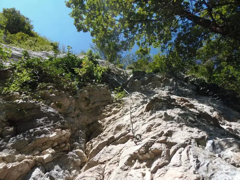
The itinerary of the Ferrata Sass del Tavarac can be ideally divided into three sections of decreasing difficulty. The first section is the most selective and demanding. The start is immediate, with a climb up a wall about thirty meters high, characterized by a shallow dihedral, requiring strength and technique due to sparse holds. The route unfolds on a vertical slab that imposes a slow, deliberate pace, with moments of strong exposure. Once past this demanding vertical section, you face a traverse to the left, very exposed and strenuous, with feet on friction and assisted by chains. This passage takes place on a narrow ledge, looking down over the crag below, and demands balance and control. The traverse leads to a gully to be climbed, at the end of which you reach a fork: to the right, you continue toward the second section; to the left, there is a possible exit route.
The second section begins with an equipped trail that overcomes a ramp and some rocky, grassy steps, leading to a second vertical wall. This one, about fifteen meters high, is less arduous than the first but by no means easy; the rock here is also less solid. Progression becomes more continuous, alternating short stretches of walking on trail with vertical rock steps. After climbing the wall, you face a traverse, less demanding than the previous one, which concludes the section. In the final part of this stretch, you cross the chain of the descent trail, which can serve as an escape route; to continue, ignore it and head toward the third section.
The third and final section opens with some sloping rocks to climb, then leads to a wall with characteristic white-yellowish rock. The difficulty is comparable to that of the wall in the second section, but the rock is less secure and requires maximum attention for hand and foot placements, considering also the exposure above the crag. This final stretch has a more horizontal and panoramic character, with the view opening up over the plain. Once this last vertical section is finished, you climb the final rocky steps to the endpoint of the via ferrata. The time for the via ferrata alone is about 45 minutes from the start, for a total of about 2 hours from the starting parking lot.
Descent
Two alternatives are available for the return. The first, more direct, involves immediately following a track and a chain to the right from the end of the via ferrata. This trail descends close to the ascent wall; it is exposed, unstable, and in some sections requires short downclimbs. It is equipped with a chain, essential but often loose. The descent is technical and concentrated, with passages on friable terrain requiring caution. You descend this way to the start of the via ferrata and then return via the approach trail, for a total of about 45 minutes from the summit and 2 hours and 45 minutes total from the start of the hike.
The second option, longer but perhaps easier, involves following a trail from the end of the via ferrata that rises slightly into the forest until it meets a mule track. Taking it to the left downhill, you skirt two climbing areas (Sasso San Salvatore and Sasso d'Erba), ignoring the junctions. Continue descending to the Eremo di San Salvatore and from there return to the parking lot by retracing the first part of the approach. This variant, longer and less technical, offers a more relaxed walking pace through the forest. It takes about 1 hour from the summit, bringing the total hike time to about 3 hours.
Useful Notes
The Ferrata Sass del Tavarac is a short itinerary but technically difficult and very demanding. The metal fixtures are minimal and, though in good condition, leave ample room for real climbing. The first section is particularly selective, and those familiar with alpine techniques will find themselves at an advantage; in some cases, using climbing shoes can prove useful during progression. The experience is predominantly vertical and physical, with constant exposure defining its character. An additional warning concerns access to the hermitage: if you decide to park near the hermitage itself, it is essential to return by 7:00 PM, as the barrier at the entrance to via San Giorgio is subsequently closed.
Track and weather
Plan the route
Preview the GPX track from the backend, download it for your GPS device, open parking directions, and check a short forecast before leaving.
Images
FAQ
What level of commitment does this via ferrata require?
ferrata.faqAnswers.commitment
How much elevation gain should I plan for?
The listed ferrata elevation gain is 170 m. Also consider approach, return and maximum altitude, because they can matter more than the equipped section alone.
Where is the route located?
Ferrata Sass del Tavarac is located in Prealpi Comasche, Como, Italy. Before leaving, check parking, access and current local conditions.
When is the best time to climb it?
The best season depends on altitude, aspect and lingering snow. Avoid storms, wet rock and uncertain conditions; start early and keep a margin for the return.
Gear and safety planning
Use the technical data on this page to plan equipment, timing and offline navigation. For a general checklist, read the equipment guide before opening the route in the app.
Video
Watch the route
Useful YouTube videos for getting a real feel for the route before you go.
Logbook
Route condition reports
Recent community notes about closures, snow, equipment damage, trail issues and current conditions.
Community
Reviews, check-ins and photos
-
0 reviews
3
3 climbers
0
Shared by the community
Community photos
Recent images uploaded by Sferrati members.
No community photos yet
Open this route in the app to add the first photo.
Reviews
Recent impressions from climbers who know the route.
No reviews yet
Be the first to review this via ferrata from the app.
Continue in the app
Track the climb, save maps offline, and sync this route to your personal profile.
Use the app to climb
Offline maps, tracking, saves, and profile sync.
Scan the code before leaving, install the app, and keep your route data ready when reception fades.
