
Technical data
- Difficulty
- Difficile
- Status
- aperta
- Distance
- 4,8 km
- Total duration
- 3 h
- Approach
- 20 min
- Ferrata time
- 2 h
- Elevation gain
- 300 m
- Max altitude
- 830 m
Route planning
How to plan Ferrata della Falconera
Ferrata della Falconera is in Monte Tovo, Vercelli, Italy and is rated Molto Difficile. Available route data lists about 3 h total time, 4,8 km of distance, 300 m of elevation gain.
For day planning, consider an approach of about 20 min, about 120 min on the cable, a maximum altitude near 830 m. Reported route features include: Ponti sospesi, Avvicinamento corto.
The page includes a parking or driving-directions reference. A GPX track is available to review and download.
As with every via ferrata, evaluate season, lingering snow, storms, crowds and equipment condition. Page last updated on 7/4/2026.
Features
Description
Overview
The Ferrata della Falconera is a modern, athletic route that unfolds across a vertical wall above Varallo, in the province of Vercelli. Its demanding and physically taxing nature, with pronounced exposure and overhanging sections, makes it suitable exclusively for experienced hikers in excellent physical condition. The presence of passages that tend to pull you outward makes using a via ferrata lanyard or quickdraws highly recommended for safe progression.
Approach
The itinerary begins in Varallo. Once in town, park in the large area near the "Casa Serena" retirement home. From the parking area, cross the road to take a mule track marked by an information board dedicated to the via ferrata. The climb through the woods takes about ten minutes to a junction, where you continue along a mid-slope trail that leads to a short equipped section, finally reaching the start sign for the Ferrata della Falconera (about 20 minutes from the car). The start is characterized by an initial ledge-like morphology with compact rock. A bench has been placed nearby for putting on your harness, but extreme caution is advised due to the risk of falling rocks. It is therefore recommended to wear your helmet, and ideally all your gear, from the very start.
Via Ferrata
From the start, move a couple of meters horizontally to the right, then ascend a first wall of well-supported rock that gradually bends to the right. The environment is immediately vertical, with solid rock allowing continuous progression. Soon you encounter numerous stirrups that facilitate the vertical climb, quickly gaining altitude and exposure, and offering a first taste of a slight overhang. You then reach a traverse to the right, first horizontal and then diagonal, known as the "Traverso della Chiappa Tremante" (Traverse of the Trembling Leg). This passage, developed on an exposed ledge, requires attention to movement. After this section, you arrive at a wider ledge that skirts the "Grotta del Fico" (Fig Cave) and leads beneath a first, more challenging vertical wall. The climb continues up a slab toward a rocky roof. Beneath this roof, with ropes on both sides, you bypass it to the left in a short section reminiscent of a dihedral. From here, on what is called the "Cengia dei 4000" (Ledge of the 4000ers), you enjoy a magnificent view of the 4000-meter peaks on clear days. This sector offers a moment of more horizontal, panoramic progression.
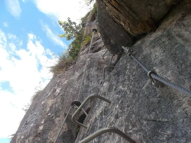
The exposure now becomes significant. You reach the "Cengia della Campana" (Bell Ledge), marked by a small metal bell, which you traverse to the right to position yourself beneath a vertical wall. The pace of the route becomes more physical and sustained. Here you tackle the two most challenging passages of the entire route. You ascend the wall to a first very bulging roof, which requires agility and a quick carabiner change to avoid excessively tiring your arms. The passage, though short (about two meters), is exposed and strenuous. After overcoming it, you continue vertically following the rungs to encounter almost immediately a second similar roof, which features a marked outward lean. This too is overcome with great exposure and physical effort, before concluding the ascent of this long and tough wall. A panoramic terrace offers a well-deserved rest point to catch your breath and admire the landscape. For the two overhanging sections mentioned, a lanyard can be of great help. This section represents the athletic and technical heart of the route.
The climb continues up a couple of easier walls, then enters a stepped ridge section, alternately rocky and grassy, which leads to the "Via col Vento" (Gone with the Wind) suspension bridge. This bridge, with four ropes and relatively stable, is similar to other structures in Alto Piemonte (like on the Ferrata Detomasi at Cimalegna); the intertwined ropes can make progression a bit cumbersome, requiring you to step over them in some spots. However, it is possible to cross using only two ropes, like a classic Tibetan bridge. Beyond the bridge, an easy but exposed horizontal traverse to the right introduces the final passages. You climb a last vertical wall, tackle some rock steps and a couple of rocky ledges, finally reaching the "Cresta del Traguardo" (Finish Ridge). This, after a few easy but well-protected passages, marks the end of the actual climb, at the summit register. The climbing time for the via ferrata is about 2 hours from the start (2 hours and 20 minutes total from the car). The character of the route is predominantly vertical, with an airy finish along the ridge.
Descent
The most direct descent back to Varallo involves following the Sentiero 636C in a northeast direction, then taking the 636B toward the Laghetto di Scarpia (Scarpia Lake). Once at the lake, descend along the 636 trail, which returns to Varallo (about 40 minutes from the end of the via ferrata, for a total of 3 hours from the start of the hike). Along the return path, less than 10 minutes from the end of the via ferrata, there are three stone tables available for a possible rest and snack. The descent trail winds through a wooded environment, offering a stark contrast to the exposure just experienced.
Useful Notes
The Ferrata della Falconera is excellently equipped and is characterized more by athletic commitment than by extreme technical difficulty. The elevation gain is considerable, and the two key passages are physically tough, but progression is always well guided by the cables, reducing the need for actual climbing. Exposure is high and constant throughout the route, with a predominantly vertical development on compact rock. A useful safety detail is that the bolts are numbered, making it easier to pinpoint your location in an emergency.
A unique feature in the Italian landscape is the presence of a nighttime lighting system, generally active on Saturday evenings and near certain holidays (specific days and times can be found on dedicated materials). However, even if using the route at night, a headlamp is essential for the steep return trail. To best tackle the more difficult sections, it can be helpful to consult a guide on how to safely simulate a belay along a via ferrata. The experience is primarily physical, with technical moments concentrated in the overhangs.
For those looking to extend the activity, a natural continuation is the nearby Ferrata del Partusac, whose start is located along the return trail. In the area, other interesting alternatives include the Ferrata dei Picasass on Lake Maggiore (about an hour's drive) or the Biella-area via ferratas such as the Ferrata della Balma, the Ferrata Nito Staich, or the Sentiero Attrezzato dell'Infernone.
Track and weather
Plan the route
Preview the GPX track from the backend, download it for your GPS device, open parking directions, and check a short forecast before leaving.
Images
FAQ
What level of commitment does this via ferrata require?
ferrata.faqAnswers.commitment
How much elevation gain should I plan for?
The listed ferrata elevation gain is 300 m. Also consider approach, return and maximum altitude, because they can matter more than the equipped section alone.
Where is the route located?
Ferrata della Falconera is located in Monte Tovo, Vercelli, Italy. Before leaving, check parking, access and current local conditions.
When is the best time to climb it?
The best season depends on altitude, aspect and lingering snow. Avoid storms, wet rock and uncertain conditions; start early and keep a margin for the return.
Gear and safety planning
Use the technical data on this page to plan equipment, timing and offline navigation. For a general checklist, read the equipment guide before opening the route in the app.
Video
Watch the route
Useful YouTube videos for getting a real feel for the route before you go.
Logbook
Route condition reports
Recent community notes about closures, snow, equipment damage, trail issues and current conditions.
Community
Reviews, check-ins and photos
-
0 reviews
2
2 climbers
0
Shared by the community
Community photos
Recent images uploaded by Sferrati members.
No community photos yet
Open this route in the app to add the first photo.
Reviews
Recent impressions from climbers who know the route.
No reviews yet
Be the first to review this via ferrata from the app.
Continue in the app
Track the climb, save maps offline, and sync this route to your personal profile.
Use the app to climb
Offline maps, tracking, saves, and profile sync.
Scan the code before leaving, install the app, and keep your route data ready when reception fades.
