
Technical data
- Difficulty
- Difficile
- Status
- aperta
- Distance
- 1,4 km
- Total duration
- 2 h
- Approach
- 10 min
- Ferrata time
- 1 h
- Elevation gain
- 250 m
- Max altitude
- 1450 m
Route planning
How to plan Ferrata Gabi Simplon
Ferrata Gabi Simplon is in Alpi Lepontine, Verbania, Italy and is rated Difficile. Available route data lists about 2 h total time, 1,4 km of distance, 250 m of elevation gain.
For day planning, consider an approach of about 10 min, about 60 min on the cable, a maximum altitude near 1450 m. Reported route features include: Ponti sospesi, Avvicinamento corto.
The page includes a parking or driving-directions reference. A GPX track is not available yet, so bring an alternative map source.
As with every via ferrata, evaluate season, lingering snow, storms, crowds and equipment condition. Page last updated on 7/4/2026.
Features
Description
Overview
The Gabi Simplon Via Ferrata is an athletic, concentrated route located in Swiss territory just beyond the Simplon Pass. It is characterized by its brevity and the presence of numerous artificial holds, which facilitate progression while still presenting some physically demanding passages that should not be underestimated.
The route unfolds on a compact, vertical wall sculpted from the solid crystalline rock typical of the area. The progression is continuous, with no significant breaks, offering a constant physical challenge. The path alternates between pure climbing sections on rungs and pegs and short walking stretches on ledges, maintaining a tight rhythm and marked exposure right from the start.
Approach
The starting point is in Switzerland, after crossing the border and continuing downhill along the Simplon main road. After passing through eight tunnels, some of which are very short, exit the eighth one. On the left side of the road, a quarry is visible with a small access road. On holidays, it is possible to park near the quarry itself; otherwise, you can use a large parking area along the main road and walk down the access road. Coordinates for Google Maps are easily found online. From the parking area, an information board shows the layout of the Gabi Simplon Via Ferrata and any escape routes. The start is immediate, reachable by descending a few meters over a scree slope.
The setting is typical of a high alpine valley, with the wall rising sharply above the streambed. The terrain is rugged, dominated by smooth slabs and dihedrals that rise directly from the base scree. The quick access and the absence of a long approach hike contribute to the concentrated, athletic character of the entire experience.
Via Ferrata
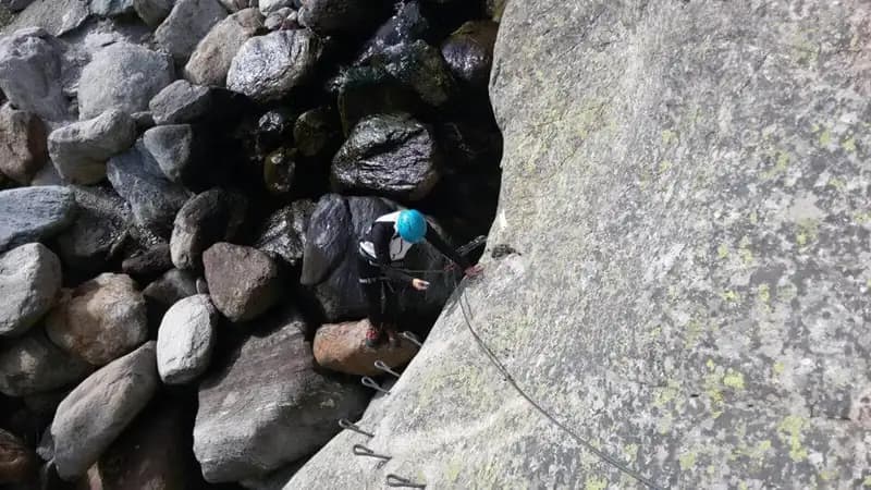
The route begins by ascending a boulder equipped with metal stirrups. After gaining the upper edge, you skirt it to engage a short traverse to the right on pegs, which leads to a suspension bridge about ten meters long. Depending on the season, a more or less torrential stream may flow beneath it. This bridge and the described start constitute a variant; the original route, avoiding the bridge, reaches the same point from the left. After crossing the bridge, the route becomes vertical for about fifteen meters, with stirrups and pegs, until it joins the cable coming from the alternative start. You then continue to the right on a traverse over pegs to an edge, which you round, leaving the bridge behind.
The climb continues vertically up a dihedral richly equipped with artificial holds. You reach a grassy section, move briefly to the right onto a ledge, and attack a very well-equipped vertical wall, characterized by a long series of pegs and stirrups. This section, despite the abundance of aids, offers the pleasure of moving on excellent quality rock. You then shift to the right along a ledge that evolves into an exposed traverse on metal pegs, not difficult but certainly thrilling. Short ledges and traverses alternate for a few minutes, until you ascend a diagonal rocky ramp.
The pace is sustained and uninterrupted. The wall, although richly equipped, demands constant muscular effort due to the continuous vertical progression. The exposure becomes increasingly evident as you climb, with the traverses on pegs providing moments of strong sensation while remaining technically manageable.
You then tackle a comfortable vertical wall with many stirrups, followed by a traverse to the right on numerous pegs. The cable temporarily stops for a short trail section, before resuming on another straight wall full of holds. You overcome a traverse under a roof, initially on pegs and then on a wider ledge, before walking a grassy ledge to the right. The progression resumes vertically on stirrups, before a very exposed traverse to the left on pegs. The cable restarts vertically with a slight overhang, aided by wide metal rungs. After passing this section, the wall continues for about twenty meters on a long series of rungs, up to a second overhanging section similar to the previous one. Once past it, you arrive on a small grassy terrace.
The character of the route is decidedly vertical and physical. The rock, excellent and compact, allows for fluid but demanding progression, where endurance is tested by the long stretches of climbing on stirrups and rungs. The two slightly overhanging passages, although well-equipped, represent the most challenging points and complete the athletic profile of the route.
Following the cable, you reach a donation box with the summit register. A few more meters of cable and the Gabi Simplon Via Ferrata concludes, with a climbing time of about one hour from the start.
Descent
The descent follows a paved road that quickly leads to a yellow trail marker. This indicates a path through the woods that conveniently returns to the main road below in about twenty minutes from the end of the via ferrata.
The return is quick and logical, closing an efficient loop that brings you back to the starting point. The forest path offers a pleasant walk in contrast to the vertical effort just completed, allowing your muscles to relax.
Useful Notes
It is possible to make a voluntary donation at the box placed near the end of the route, thus contributing to its maintenance. For those who wish to avoid the suspension bridge, there is the option of walking along the main road towards the tunnel, where a yellow sign indicates the short path that leads directly to the original start of the via ferrata. Heading back towards Italy, other interesting via ferratas are nearby, such as the Lago Via Ferrata, the Guide di Macugnaga Via Ferrata, and the Picasass Via Ferrata on Lake Maggiore.
The via ferrata presents itself as an ideal route for an intensive training session or a short but substantial day out. Its concentrated nature, excellent maintenance, and position straddling the border make it a popular destination for those seeking a technical and scenic experience without excessive approach times.
Track and weather
Plan the route
Preview the GPX track from the backend, download it for your GPS device, open parking directions, and check a short forecast before leaving.
GPX track unavailable
This route does not include a downloadable track yet.
Images
FAQ
What level of commitment does this via ferrata require?
ferrata.faqAnswers.commitment
How much elevation gain should I plan for?
The listed ferrata elevation gain is 250 m. Also consider approach, return and maximum altitude, because they can matter more than the equipped section alone.
Where is the route located?
Ferrata Gabi Simplon is located in Alpi Lepontine, Verbania, Italy. Before leaving, check parking, access and current local conditions.
When is the best time to climb it?
The best season depends on altitude, aspect and lingering snow. Avoid storms, wet rock and uncertain conditions; start early and keep a margin for the return.
Gear and safety planning
Use the technical data on this page to plan equipment, timing and offline navigation. For a general checklist, read the equipment guide before opening the route in the app.
Video
Watch the route
Useful YouTube videos for getting a real feel for the route before you go.
Logbook
Route condition reports
Recent community notes about closures, snow, equipment damage, trail issues and current conditions.
Community
Reviews, check-ins and photos
-
0 reviews
0
0 climbers
0
Shared by the community
Community photos
Recent images uploaded by Sferrati members.
No community photos yet
Open this route in the app to add the first photo.
Reviews
Recent impressions from climbers who know the route.
No reviews yet
Be the first to review this via ferrata from the app.
Continue in the app
Track the climb, save maps offline, and sync this route to your personal profile.
Use the app to climb
Offline maps, tracking, saves, and profile sync.
Scan the code before leaving, install the app, and keep your route data ready when reception fades.
