
Sentiero Attrezzato dell'Ideale
Cima d'Ambiez · Trento · Italy
Technical data
- Difficulty
- Moderatamente Difficile
- Status
- aperta
- Distance
- 6 km
- Total duration
- 10 h 30 min
- Approach
- 3 h
- Ferrata time
- 2 h 30 min
- Elevation gain
- 400 m
- Max altitude
- 1750 m
Route planning
How to plan Sentiero Attrezzato dell'Ideale
Sentiero Attrezzato dell'Ideale is in Cima d'Ambiez, Trento, Italy and is rated Moderatamente Difficile. Available route data lists about 10 h 30 min total time, 6 km of distance, 400 m of elevation gain.
For day planning, consider an approach of about 180 min, about 150 min on the cable, a maximum altitude near 1750 m. Reported route features include: Ghiacciaio, Scale, Itinerario lungo, Funivia all'andata.
The page includes a parking or driving-directions reference. A GPX track is not available yet, so bring an alternative map source.
As with every via ferrata, evaluate season, lingering snow, storms, crowds and equipment condition. Page last updated on 7/4/2026.
Features
Description
Overview
The Sentiero Attrezzato dell'Ideale is a route of high technical difficulty and immense scenic impact, unfolding at the base of the dizzying walls of Cima d'Ambiez in the central sector of the Brenta Group. Its character-marked by numerous vertical passages and constant exposure-makes it a true via ferrata in every sense. It is often used as a direct link between Rifugio XII Apostoli and Rifugio Agostini, or as an ideal extension of the Ferrata Ottone Brentari, enabling a magnificent high-altitude loop starting from Rifugio Pedrotti.
Approach
The most common access begins from the town of Pinzolo. After parking near the valley station of the cable car to Doss del Sabion, take the lift for the first ascent. From the top station, the approach to Rifugio XII Apostoli follows the well-known Sentiero Attrezzato della Scala Santa (marked as CAI trail 307), a hiking route with some protected sections that requires about three hours of walking.
Via Ferrata
From Rifugio XII Apostoli, take trail 307 east toward Bocchetta dei Camosci. The climb proceeds up a steep but non-technical debris slope, leading into a broad valley dominated by the Vedretta d'Agola glacier. The route then ascends the left lateral moraine, winding across ledges, short rock steps, and equipped sections, until it gains the panoramic Bocchetta dei Camosci (2784 m), reached in about an hour from the hut. From this pass, the horizon opens onto the Vedretta dei Camosci, with the majestic Cima Tosa and, to the right, the severe profile of Cima d'Ambiez.
From here, follow the signs for the Sentiero dell'Ideale, which climbs diagonally toward Bocca d'Ambiez. Ignore the left fork for the Sentiero Alpinistico Martinazzi and continue right to enter the technical heart of the route. The trail traverses diagonally (north-northeast) across a section of glacier, at times steep, where crampons may be necessary if residual snow is present. After crossing the snowfield, an ascending traverse leads to a first series of equipped sections of moderate difficulty.
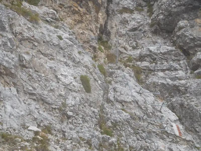
Next comes a metal ladder, followed by a sequence of iron steps that allow for rapid and efficient altitude gain. Ignore another fork for the Sentiero Martinazzi; you now face a vertical wall that is well-equipped and rich in both natural and artificial holds. After climbing this, a protected ramp leads to the final meters before emerging at Bocca d'Ambiez (2870 m), reached in about 30 minutes from Bocchetta dei Camosci (for a total of 1 hour and 30 minutes from Rifugio XII Apostoli).
The pace of the route is sustained and continuous, with progression alternating between short sections of moraine walking and well-protected vertical sequences. The environment is severe, shaped by ice and dominated by walls of compact dolomite, with the route often unfolding across exposed ledges or directly up vertical slabs.
Now begins the descent toward Rifugio Agostini, along the so-called Sentiero del Cege. This section, highly exposed and potentially subject to falling debris, demands maximum caution, a helmet, and a quick step. The route runs over well-gripped rock steps and vertical walls, with good holds both natural and artificial. After descending these equipped sections, you reach the expanse of the Vedretta d'Ambiez (about 2800 m), roughly 30 minutes from the Bocca.
You then descend the glacial snowfield, heading toward the junction with CAI trail 358 for the Ferrata Brentari (which leads to Rifugio Pedrotti). From this junction, continue toward Rifugio Agostini, cutting back across the glacier following distinctive red marker poles. Overcome the last easy equipped sections in descent and, at the junction with the trail for the Ferrata Castiglioni (to the right), continue straight, finally arriving at Rifugio Agostini. The total time from Bocca d'Ambiez to the hut is about an hour, for a total of 2 hours and 30 minutes from Rifugio XII Apostoli.
The descent along the Sentiero del Cege is technical and physical, with counterbalanced moves on solid rock but within a gully often prone to stonefall. The exposure is pronounced, and the pace becomes more cautious, requiring a good dose of mental endurance.
Descent
From Rifugio Agostini, the return to the starting point can follow two main routes. The first option is to return by the same path, ascending the Sentiero Attrezzato dell'Ideale back to Rifugio XII Apostoli (about 2h 30'). Alternatively, you can opt for the Ferrata Castiglioni, which also leads to Rifugio XII Apostoli via Bocca dei Due Denti, with a route generally less affected by snow and ice (about 2h 30'). Once back at Rifugio XII Apostoli, descend along the Sentiero Attrezzato della Scala Santa to the top station of the cable car for Pinzolo (about 2h 30' of descent).
Useful Notes
The route takes place in a severe alpine environment, crossing the snowfields of the Vedretta d'Ambiez and Vedretta dei Camosci. The use of crampons and an ice axe is strongly recommended to safely tackle these sections, paying close attention to polished ice, especially near Bocca d'Ambiez. The metal equipment along the route is in good condition and recently maintained. Given the exposure and the risk of falling rocks on the descent toward the Vedretta d'Ambiez, a helmet is essential. The route lends itself to being combined into a grand loop with the Ferrata Brentari, starting from Rifugio Pedrotti, or linked with other equipped itineraries in the Brenta Group, such as the Sentiero Attrezzato Apolloni or the famous Ferrate delle Bocchette.
Track and weather
Plan the route
Preview the GPX track from the backend, download it for your GPS device, open parking directions, and check a short forecast before leaving.
GPX track unavailable
This route does not include a downloadable track yet.
Images
FAQ
What level of commitment does this via ferrata require?
ferrata.faqAnswers.commitment
How much elevation gain should I plan for?
The listed ferrata elevation gain is 400 m. Also consider approach, return and maximum altitude, because they can matter more than the equipped section alone.
Where is the route located?
Sentiero Attrezzato dell'Ideale is located in Cima d'Ambiez, Trento, Italy. Before leaving, check parking, access and current local conditions.
When is the best time to climb it?
The best season depends on altitude, aspect and lingering snow. Avoid storms, wet rock and uncertain conditions; start early and keep a margin for the return.
Gear and safety planning
Use the technical data on this page to plan equipment, timing and offline navigation. For a general checklist, read the equipment guide before opening the route in the app.
Video
Watch the route
Useful YouTube videos for getting a real feel for the route before you go.
Logbook
Route condition reports
Recent community notes about closures, snow, equipment damage, trail issues and current conditions.
Community
Reviews, check-ins and photos
-
0 reviews
0
0 climbers
0
Shared by the community
Community photos
Recent images uploaded by Sferrati members.
No community photos yet
Open this route in the app to add the first photo.
Reviews
Recent impressions from climbers who know the route.
No reviews yet
Be the first to review this via ferrata from the app.
Continue in the app
Track the climb, save maps offline, and sync this route to your personal profile.
Use the app to climb
Offline maps, tracking, saves, and profile sync.
Scan the code before leaving, install the app, and keep your route data ready when reception fades.
