
Ferrata Passo della Porta alla Presolana
Presolana · Bergamo · Italy
Technical data
- Difficulty
- Moderatamente Difficile
- Status
- aperta
- Distance
- 10,7 km
- Total duration
- 6 h
- Approach
- 2 h
- Ferrata time
- 2 h 45 min
- Elevation gain
- 370 m
- Max altitude
- 2369 m
Route planning
How to plan Ferrata Passo della Porta alla Presolana
Ferrata Passo della Porta alla Presolana is in Presolana, Bergamo, Italy and is rated Moderatamente Difficile. Available route data lists about 6 h total time, 10,7 km of distance, 370 m of elevation gain.
For day planning, consider an approach of about 120 min, about 165 min on the cable, a maximum altitude near 2369 m. Reported route features include: Scale, Itinerario lungo, Funivia all'andata.
The page includes a parking or driving-directions reference. A GPX track is available to review and download.
As with every via ferrata, evaluate season, lingering snow, storms, crowds and equipment condition. Page last updated on 7/4/2026.
Features
Description
Overview
The Ferrata del Passo della Porta is a substantial alpine experience, unfolding across the northern and eastern flanks of the Presolana massif and culminating on the summit of Monte Visolo. While technically classifiable as moderate, the route reveals a traditional, alpine character with a varied succession of passages in a setting that demands attention, especially given the mountain's stern reputation. From a panoramic standpoint, it ranks among the most evocative itineraries in the Bergamo Orobie Alps, an ascent that richly repays the effort invested.
The environment is distinctly Dolomitic in feel, developing across slabs, ledges, and gullies of grey limestone, often polished by ancient glacial action. The rhythm is discontinuous: at times vertical and demanding, followed by short resting sections on trail or ledge, creating an alternation that requires constant adaptation. The itinerary stands out for its marked panoramic and exposed character, offering wide, dizzying views that accompany the progression throughout.
Approach
The starting point for accessing the via ferrata is the town of Colere, in the province of Bergamo, reachable either from the Seriana Valley from Bergamo, or from Brescia via Lake Iseo and Darfo Boario Terme. The choice of parking and the corresponding approach itinerary influences the times and development of the route.
Option 1 (CAI Trail 403 via Rifugio Albani): Park on Via Carbonera in Colere, continue past a curve towards the ski lifts and cross a bridge. Then take the paved trail 403, which soon veers left into a steep, steady forest climb until the junction with trail 406 coming from Malga Polzone. Keeping left, you reach a saddle; a little higher, near the former mines, you find Rifugio Albani (1939 m, about 2h15' from the car). From the saddle, continue east along the Sentiero delle Orobie Orientali (CAI 326/401), passing the rocky outcrops of Colle della Guaita until the start of the via ferrata, indicated by trail 401 (about 20' from the saddle, total 2h30').
Option 2 (Colere Ski Gondola): Park in the large gondola parking lot. Take the first section up to Malga Polzone and the second to Cima Bianca. From here, reach Rifugio Albani in about 30 minutes, then descend to the saddle and continue as described above (total about 1h from the top station).
Option 3 (Direct CAI Trail 402): Park along Via Ole in Colere, in an available space. First ascend a forest road, then turn right into a steep ascent towards the northern bastion of the Presolana. Reaching a basin, you meet the junction with trails 326/401. Turning left, in a few minutes you are at the start of the via ferrata (about 2h from the parking).
The approach unfolds in a high-mountain environment, with morphology initially wooded that gives way to scree and rocky outcrops. The choice of option significantly affects the physical preparation required: the direct route (CAI 402) is shorter but intense, while the variant via the refuge offers a more gradual but longer approach.
Via Ferrata
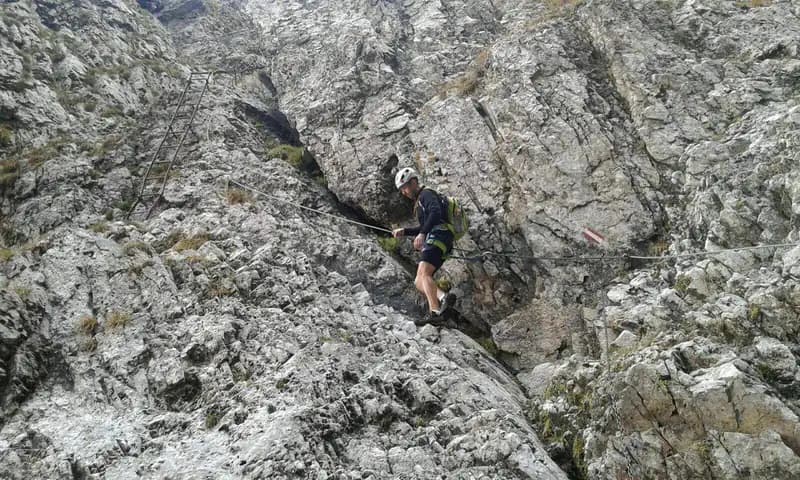
The equipped itinerary begins with two metal ladders, followed by a simple traverse to the left leading to another ladder. After this introductory section, you ascend a rocky gully equipped with a chain. The progression initially runs on the right side of the gully, then crosses it (watch for possible residual snow) and reaches the left side, climbing it for about twenty meters to a new steel cable.
From here, a diagonal traverse to the left leads to a new ladder, first vertical then more slanted, which emerges onto a short earthy ledge. A rocky step with two stirrups introduces a sloping ramp and a further metal ladder. Past it, the cable breaks for a few meters and you clip into a chain to overcome a short vertical wall (watch for occasionally friable rock). Ascending an oblique ramp, you finally arrive at the Passo della Porta, with an exceptional panorama over the Valle di Scalve.
A short ledge to the right leads to a long, exposed metal ladder. Then execute a very airy traverse to the left, well-supplied with holds, which gives access to a section of equipped trail and short rocky steps, some without cable. You reach a shorter ladder and, after climbing it, face a series of equipped rocky ledges, where you proceed climbing following the red waymarks and white-red blazes. A ledge skirts a boulder to the right, leading to an easy but decidedly exposed climb in some spots. You then enter a gully equipped with a chain, which you ascend to continue on a comfortable ledge and a ridge trail with easy rock steps.
You now overlook a beautiful glacial basin, where you must descend about 50 meters on smooth rock using the chain: maximum caution in this passage. Continue descending without equipment to a traverse to the right that skirts a corner, before crossing the basin (often with residual snow, moderate slope). Then ascend at mid-height on the opposite side of the basin, beginning a horizontal, exposed traverse with good holds. Ignoring the sign for Presolana Orientale, tackle the final climb on a rather vertical wall, using natural holds and, where necessary, the chain. The final few meters lead to the summit of Monte Visolo (about 2h45' from the start; total 4h45' with the CAI 402 approach, or 3h45' from the top gondola station).
The via ferrata develops mainly across slabs and fissures of compact limestone, with airy sections on ledges and gullies. The rhythm is discontinuous: technical, vertical sections (ladders, walls) alternate with horizontal traverses and short trail sections, requiring constant adaptation of climbing style. The exposure is marked and constant, contributing to the alpine and panoramic character of the entire ascent.
Descent
From the summit of Monte Visolo, descend towards the Passo della Presolana, ignoring the trail to the right for Bivacco Città di Clusone and continuing south on the Sentiero delle Orobie Orientali. You thus reach Rifugio Baita Cassinelli after a descent through meadows and mugo pine (about 1h45' from the summit, total 6h30'). From the refuge, descend along trails 315/316 to a junction, where you take the trail 32 to the right for the Passo della Presolana (about 45' from the refuge, total 7h15').
A more direct alternative involves taking trail 33 to the right before reaching the refuge, saving time but forgoing a possible stop.
The descent is on well-marked but sometimes uneven trails, in a high-altitude environment with open views. The pace is steady and less technical than the ascent, but still requires attention due to the length of the route and the elevation to be regained.
Useful Notes
The itinerary is doable in both directions and is an integral part of the Sentiero delle Orobie. This description covers the direction of travel that involves climbing the via ferrata.
For the return to Colere from the Passo della Presolana, you need to use the local buses (about every hour and a half). Schedules should be checked on the Bergamo transport website; tickets (indicative cost €2.65 in 2018) are available at the hotel at the pass.
Weather planning is essential. The Presolana is known for sudden changes in conditions; the hike is long and inside the via ferrata there are no easy escape routes. Furthermore, some north-facing sections may have snow or ice even at the start of the season.
The Ferrata del Passo della Porta, inaugurated in 1970, is dedicated to the memory of Corrado Fraceschi, who died during an excursion on the Presolana in 1967.
Track and weather
Plan the route
Preview the GPX track from the backend, download it for your GPS device, open parking directions, and check a short forecast before leaving.
Images
FAQ
What level of commitment does this via ferrata require?
ferrata.faqAnswers.commitment
How much elevation gain should I plan for?
The listed ferrata elevation gain is 370 m. Also consider approach, return and maximum altitude, because they can matter more than the equipped section alone.
Where is the route located?
Ferrata Passo della Porta alla Presolana is located in Presolana, Bergamo, Italy. Before leaving, check parking, access and current local conditions.
When is the best time to climb it?
The best season depends on altitude, aspect and lingering snow. Avoid storms, wet rock and uncertain conditions; start early and keep a margin for the return.
Gear and safety planning
Use the technical data on this page to plan equipment, timing and offline navigation. For a general checklist, read the equipment guide before opening the route in the app.
Video
Watch the route
Useful YouTube videos for getting a real feel for the route before you go.
Logbook
Route condition reports
Recent community notes about closures, snow, equipment damage, trail issues and current conditions.
Community
Reviews, check-ins and photos
-
0 reviews
0
0 climbers
0
Shared by the community
Community photos
Recent images uploaded by Sferrati members.
No community photos yet
Open this route in the app to add the first photo.
Reviews
Recent impressions from climbers who know the route.
No reviews yet
Be the first to review this via ferrata from the app.
Continue in the app
Track the climb, save maps offline, and sync this route to your personal profile.
Use the app to climb
Offline maps, tracking, saves, and profile sync.
Scan the code before leaving, install the app, and keep your route data ready when reception fades.
