
Ferrata Spigolo della Bandiera
Monte Spino · Brescia · Italy
Technical data
- Difficulty
- Moderatamente Difficile
- Status
- aperta
- Distance
- 11,6 km
- Total duration
- 3 h
- Approach
- 1 h 10 min
- Ferrata time
- 30 min
- Elevation gain
- 100 m
- Max altitude
- 1165 m
Route planning
How to plan Ferrata Spigolo della Bandiera
Ferrata Spigolo della Bandiera is in Monte Spino, Brescia, Italy and is rated Moderatamente Difficile. Available route data lists about 3 h total time, 11,6 km of distance, 100 m of elevation gain.
For day planning, consider an approach of about 70 min, about 30 min on the cable, a maximum altitude near 1165 m.
The page includes a parking or driving-directions reference. A GPX track is available to review and download.
As with every via ferrata, evaluate season, lingering snow, storms, crowds and equipment condition. Page last updated on 7/4/2026.
Description
Overview
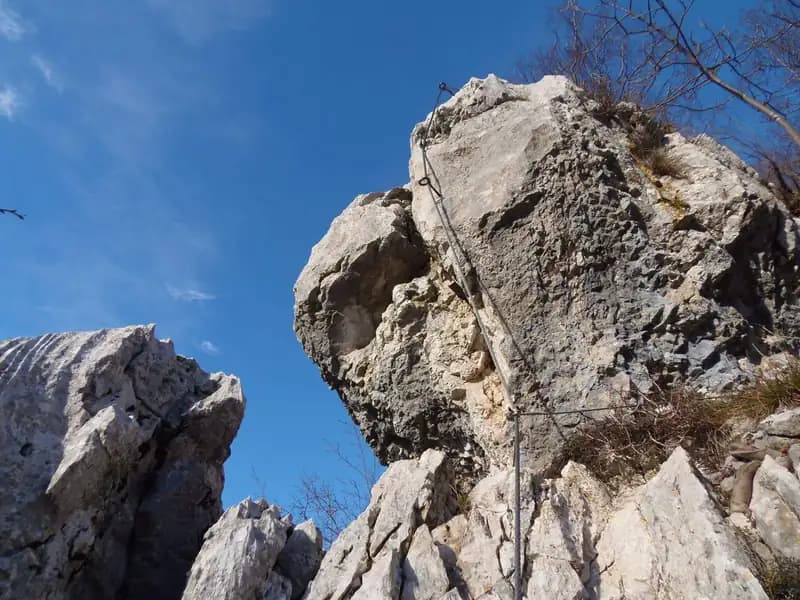
The Ferrata Spigolo della Bandiera runs along a prominent rocky spur that rises with remarkable verticality on the western side of Lake Garda, near Monte Spino. The route is predominantly vertical and exposed, offering an athletic progression that in some sections requires a dynamic lunge to reach the holds. The climbing on solid, compact rock is nonetheless pleasant and rewarding. Following a renovation in 2019, the historic line was modified, replacing the original crux with a short but intense overhanging section of high difficulty that demands concentration and a good dose of strength.
Approach
The starting point is the village of San Michele, in Gardone Riviera. From here, head into the Val di Sura as far as the Ristorante Colomber, located at a fork in the road. For parking you have two options: stop at the restaurant, or take the left-hand road, which quickly becomes a rough, unpaved track. This second choice is not recommended for low-clearance vehicles due to the surface being rutted by drainage channels. Proceeding with caution, it is still possible to find a few pull-offs for parking up to the locality of Verghere.
From the parking area, continue along the small road to the left, then take a wide path that leads to Verghere. After passing the hamlet, take the CAI 201 trail. The ascent continues with two crossings of the Barbarano stream until a junction: ignore the left-hand turn for trail 25/1 Bis and continue straight on the CAI 1. It is essential to pay close attention to the CAI trail markers, avoiding an obvious track that climbs to the left of the stream and instead crossing the watercourse once again. Ascend at a steady gradient on the CAI 1 until reaching Cascina Gemelle (950 m), about one hour from the parking area. Here, at the junction, keep left on the uphill side following signs for Rifugio Pirlo allo Spino and the via ferrata. A steep path leads shortly to another signed junction, where you turn left for the start of the Ferrata Spigolo della Bandiera, reachable in about 1 hour and 10 minutes from the parking area (1 hour and 30 minutes from Ristorante Colomber).
Via Ferrata
The equipped route begins with a moderately difficult traverse to the left, which leads to a vertical wall on the right side of the spur. The initial moves on the wall, though provided with good holds, are somewhat lacking in positive footholds. After reaching a piton that can serve as a pulling point, the spur becomes easier, offering an exposed, airy, and very rewarding climb over jagged rock. In this section it is wise to check the stability of some blocks, which may be loose. You eventually arrive at a small earthy terrace, ideal for a rest.
From the terrace begins the new line established in 2019. Move left into an exposed area, then climb while traversing in the same direction. The rock on this traverse is polished and offers few natural climbing opportunities. After a few meters you reach some good footholds that lead beneath the new crux of the route: a 4-5 meter overhanging wall. Two stirrups assist the first two meters, but to complete the overhang you will likely need to pull directly on the cable. This passage, though short, is decidedly demanding and requires concentrated physical effort. Once past it, you find yourself beneath the iconic spur of the old line, which you bypass on the right without climbing it. Instead, ascend a small wall to its right with the help of a stirrup, rejoining the original route a little higher on the final crest.
This last crest section is exposed but not difficult, with the cable serving mainly as a handrail. The equipment ends shortly, and you continue on a path to the summit flag, which marks the end of the Ferrata Spigolo della Bandiera. The time on the via ferrata itself is about 30 minutes from the start, for a total of 1 hour and 40 minutes from the beginning of the hike.
Descent
From the end of the route, follow the most obvious tracks: left toward Rifugio Pirlo allo Spino or right toward Passo dello Spino. To return to your car from Rifugio Pirlo, you can take the most direct path, which leads back to the junction at the start of the ferrata and then to the parking area (total time about 3 hours). An alternative is to first follow the trail to Passo dello Spino, from where you can see the start of the Ferrata Ernesto Franco, and then continue on the CAI 1 trail to the junction encountered on the approach (total time about 3 hours and 30 minutes). The last option, feasible only if you left your car at Ristorante Colomber, is to descend the wide forest road, which with broad switchbacks and a moderate gradient leads back to the restaurant (total time about 4 hours).
Useful Notes
The Ferrata Spigolo della Bandiera is a short but very exposed and vertical route, ideal as a test of progression after tackling less demanding via ferratas. It features sections lacking natural or artificial holds, requiring a certain use of arm strength and an athletic approach. The exposure is pronounced for almost the entire length, peaking in the overhanging passage before the final crest. The rock, however, is generally good and in many places invites confident climbing. From the summit of Monte Spino you enjoy a beautiful view of Lake Garda. For combining with other equipped routes in the area, note that the nearby Ferrata Ernesto Franco has been dismantled and replaced by a small crag, reachable in 10 minutes of descent from Rifugio Pirlo along the CAI 1 trail. Other possibilities in the region include the Sentiero Attrezzato Sperone del Crocefisso or the via ferratas in the Lake Idro area, such as the Ferrata Crench, the Ferrata Fregio, and the Ferrata delle Ginestre.
Track and weather
Plan the route
Preview the GPX track from the backend, download it for your GPS device, open parking directions, and check a short forecast before leaving.
Images
FAQ
What level of commitment does this via ferrata require?
ferrata.faqAnswers.commitment
How much elevation gain should I plan for?
The listed ferrata elevation gain is 100 m. Also consider approach, return and maximum altitude, because they can matter more than the equipped section alone.
Where is the route located?
Ferrata Spigolo della Bandiera is located in Monte Spino, Brescia, Italy. Before leaving, check parking, access and current local conditions.
When is the best time to climb it?
The best season depends on altitude, aspect and lingering snow. Avoid storms, wet rock and uncertain conditions; start early and keep a margin for the return.
Gear and safety planning
Use the technical data on this page to plan equipment, timing and offline navigation. For a general checklist, read the equipment guide before opening the route in the app.
Video
Watch the route
Useful YouTube videos for getting a real feel for the route before you go.
Logbook
Route condition reports
Recent community notes about closures, snow, equipment damage, trail issues and current conditions.
Community
Reviews, check-ins and photos
-
0 reviews
0
0 climbers
0
Shared by the community
Community photos
Recent images uploaded by Sferrati members.
No community photos yet
Open this route in the app to add the first photo.
Reviews
Recent impressions from climbers who know the route.
No reviews yet
Be the first to review this via ferrata from the app.
Continue in the app
Track the climb, save maps offline, and sync this route to your personal profile.
Use the app to climb
Offline maps, tracking, saves, and profile sync.
Scan the code before leaving, install the app, and keep your route data ready when reception fades.
