
Sentiero Attrezzato Chiesa
Dolomiti di Fiemme · Trento · Italy
Technical data
- Difficulty
- Moderatamente Difficile
- Status
- aperta
- Distance
- 11,7 km
- Total duration
- 5 h 30 min
- Approach
- 1 h
- Ferrata time
- 1 h 45 min
- Elevation gain
- 390 m
- Max altitude
- 1370 m
Route planning
How to plan Sentiero Attrezzato Chiesa
Sentiero Attrezzato Chiesa is in Dolomiti di Fiemme, Trento, Italy and is rated Moderatamente Difficile. Available route data lists about 5 h 30 min total time, 11,7 km of distance, 390 m of elevation gain.
For day planning, consider an approach of about 60 min, about 105 min on the cable, a maximum altitude near 1370 m. Reported route features include: Scale.
The page includes a parking or driving-directions reference. A GPX track is available to review and download.
As with every via ferrata, evaluate season, lingering snow, storms, crowds and equipment condition. Page last updated on 7/4/2026.
Features
Description
Overview
The Sentiero Attrezzato Chiesa is a highly rewarding alpine hiking route set in the wild, narrow confines of Val Scura, near Levico Terme. The classic approach is a loop that combines the via ferrata with the panoramic Sentiero del Menador for the return. The difficulty is moderate, but the route demands a solid comfort level with mountain terrain: the ground is often variable and unstable, with gravelly and scree-filled sections that affect progress. The setting, dominated by the Rio Bianco and its waterfalls, is especially spectacular in spring and autumn, when the water flow is at its peak.
Approach
Access begins from the town of Levico Terme, heading south toward Lochere to the Albergo Paoli, where there is a large parking area. From here, follow the paved road uphill to the first switchback. At the curve, a signpost and a red plaque mark the entrance to the forest trail on the left. Take a clear, continuous ascending path that stays on the left orographic side of Val Scura, with Monte Pegolara to the right and Monte Calmo to the left. The route gradually penetrates deeper into the valley, requiring six crossings of the Rio Bianco before reaching the start of the via ferrata. The surroundings become increasingly dramatic, with towering rock spires framing the way. After about an hour of hiking and 850 meters of elevation gain from the parking lot, you reach the first section of fixed cables.
Via Ferrata
The climb begins with a cable-assisted ascent up to a saddle. Once over it, you traverse a scree ledge, easy but often slippery, then drop slightly in elevation via a metal ladder toward the stream. Here, a rocky pinnacle seems to block the valley. After another crossing of the Rio Bianco, you tackle a second metal ladder that allows you to get past a large boulder, followed shortly by a third ladder. Continue along a ledge at the stream's edge, where caution is needed: the steel cable tends to push you outward, and the ground is often damp and slick. After another ladder, the trail becomes more comfortable and offers stunning views of the surrounding mountains, waterfalls, and streams. Following this easier stretch, the gradient steepens over loose, unstable soil until you reach a panoramic viewpoint overlooking the Valsugana.
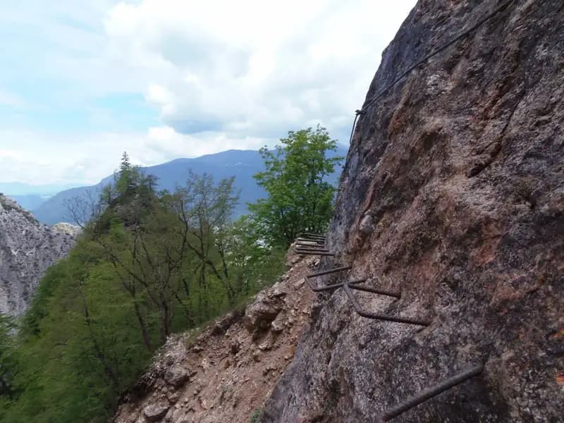
Here begins the second part of the route, which immediately presents an exposed but not difficult traverse, equipped with support stirrups. This is followed by a comfortable ledge and another metal ladder. The trail then continues on unsecured path, descends into a scree gully, and tackles what is likely the most challenging section of the route: climbing a sloping wall formed by natural steps, requiring concentration. You then reach two metal ladders to be climbed in succession. After them, the trail continues to a rather demanding descent over scree. The ascent resumes on unstable but non-technical ground, where you encounter the metal plaque dedicated to Clemente Chiesa, after whom the via ferrata is named. Once the scree section is completed, you pass near a beautiful waterfall and take a rocky ledge to the right. Follow it all the way, climb a final ladder leaning against a boulder, and cross the stream between some rocks. A last metal ladder concludes the via ferrata, leading to a plateau at 1247 meters in elevation. The travel time from the start is about 2 hours and 45 minutes, with 1 hour and 45 minutes dedicated to the ferrata itself.
Descent
After finishing the ferrata, take the forest trail heading south toward the Seghetta area. At the first junction, keep left, following marker 201 toward Baita Cangi. Although not the fastest route, the recommended return is via the Sentiero del Menador, which runs through the nearby Val Pisciavacca. At the next junction, keep left again to join this pleasant and varied trail, which with constant ups and downs, some slippery sections on scree, small bridges, and stream crossings, leads back down the valley. At the end of the Sentiero del Menador, about 2 hours and 30 minutes after finishing the ferrata, keep left to follow Via delle Valli, which brings you back to the provincial road used for the drive in. Keeping left once more, you quickly reach the parking lot at Albergo Paoli. The entire loop takes about 5 hours and 30 minutes of total walking time.
Useful Notes
The Sentiero Attrezzato Chiesa, which by pure technical standards would be classified as easy, currently presents some challenges. Following maintenance work that began in 2017, some sections lack equipment or have not been fully restored. This situation significantly raises the actual difficulty level of the route. To proceed safely, it is therefore essential to have a very steady foot and, for rope teams, to bring a rope for possible belay maneuvers on the more demanding passages. Despite this, the environment of Val Scura remains extremely evocative and, thanks to its low elevation, is a route suitable even for the shoulder seasons. The main objective difficulty comes from the often unstable, gravelly, and crumbly ground, so using telescopic trekking poles can be a great help in improving stability. For maps, the Alta Valsugana map is recommended.
Track and weather
Plan the route
Preview the GPX track from the backend, download it for your GPS device, open parking directions, and check a short forecast before leaving.
Images
FAQ
What level of commitment does this via ferrata require?
ferrata.faqAnswers.commitment
How much elevation gain should I plan for?
The listed ferrata elevation gain is 390 m. Also consider approach, return and maximum altitude, because they can matter more than the equipped section alone.
Where is the route located?
Sentiero Attrezzato Chiesa is located in Dolomiti di Fiemme, Trento, Italy. Before leaving, check parking, access and current local conditions.
When is the best time to climb it?
The best season depends on altitude, aspect and lingering snow. Avoid storms, wet rock and uncertain conditions; start early and keep a margin for the return.
Gear and safety planning
Use the technical data on this page to plan equipment, timing and offline navigation. For a general checklist, read the equipment guide before opening the route in the app.
Video
Watch the route
Useful YouTube videos for getting a real feel for the route before you go.
Logbook
Route condition reports
Recent community notes about closures, snow, equipment damage, trail issues and current conditions.
Community
Reviews, check-ins and photos
-
0 reviews
0
0 climbers
0
Shared by the community
Community photos
Recent images uploaded by Sferrati members.
No community photos yet
Open this route in the app to add the first photo.
Reviews
Recent impressions from climbers who know the route.
No reviews yet
Be the first to review this via ferrata from the app.
Continue in the app
Track the climb, save maps offline, and sync this route to your personal profile.
Use the app to climb
Offline maps, tracking, saves, and profile sync.
Scan the code before leaving, install the app, and keep your route data ready when reception fades.
