
Ferrata Strada degli Alpini
Bolzano · Italy
Moderately Difficult
Duration: 8 hDistance: 11 km
1.9 km from this ferrataSimilar difficulty
View route
Croda Rossa di Sesto · Bolzano · Italy
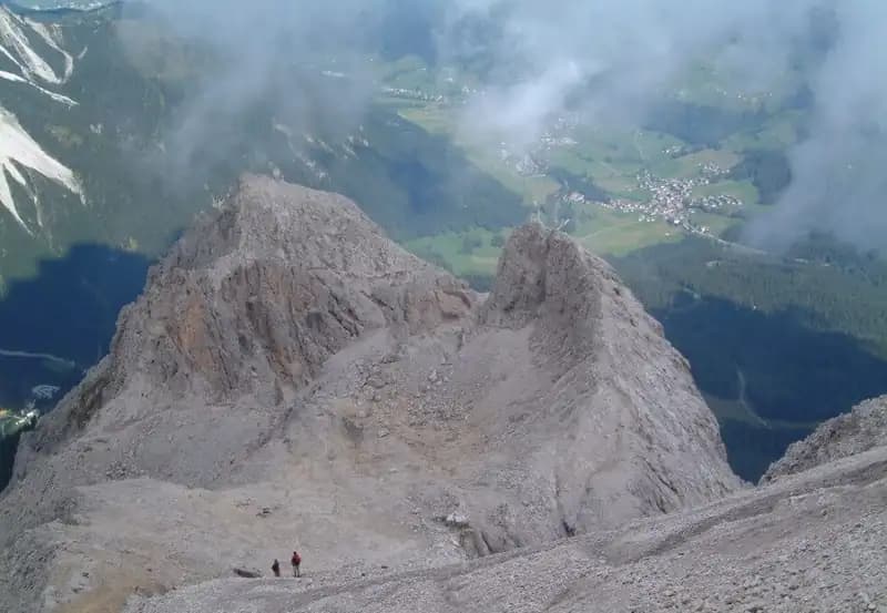
The Ferrata dei Costoni is the most accessible equipped route to the summit of the Croda Rossa di Sesto, in the heart of the Dolomites. The route begins with a series of metal ladders that overcome an initial rocky step, then continues across slabs and finishes with the ascent of a narrow gully. Although the individual passages do not require any particular technical skill, the itinerary is nonetheless long and demanding-a factor to consider when planning. Its predominantly northern exposure means that lingering snowfields can persist even late in the season, introducing an additional element of risk.
The route unfolds mainly along ridges and ledges on the northern flank, offering a continuous and progressive line. The rock, typical dolomite, features compact sections interspersed with smooth slabs. The pace is sustained, with a steady climb broken only by short flat stretches near the ruins; exposure is marked but not extreme, giving the route a predominantly scenic and physical character rather than a technical one.
The starting point is the top station of the chairlift that runs from Moos in Val Pusteria up to the Prati di Croda Rossa. From the station, it's just a few minutes to the Rifugio Prati di Croda Rossa (1924 m). From here, take the sentiero 15 heading southeast. The trail climbs at a moderate gradient across grassy slopes to a first junction: ignore the sentiero 100 for the Ferrata alla Croda Rossa (a different route) on the left, and the sentieri 18 and 19 on the right, continuing straight on sentiero 15. Shortly after, you reach a second junction: leave sentiero 15, which continues traversing, and instead take the sentiero 15B on the left, which climbs steeply toward the slopes of the Croda Rossa. The approach from the chairlift top station takes about 30 minutes.
The approach crosses morphologically simple terrain, through meadows and debris cones at the base of the wall. The pace is steady, allowing for a gradual warm-up, while the surroundings shift from gentle to more alpine as you near the start of the via ferrata.
From the start, a steep section of trail leads to a first vertical step, overcome by a series of metal ladders. The first ladder is the longest, followed by shorter ones that allow you to gain height quickly. Continuing up a broad scree slope, you reach some equipped rock sections, which you climb to a small saddle. Here, a trail joins from the left. You are now near a terrace where remains of World War I barracks are visible. Continue straight, initially with a slight descent, then climb again toward more wartime ruins. At this point, the summit cross becomes clearly visible, reached after ascending a final vertical equipped section and some rocky slabs. The summit of the Croda Rossa di Sesto (2936 m) is reached in about 2 hours and 15 minutes from the start of the ferrata, for a total ascent time of 3 hours from the departure point.
The route alternates vertical ladder sections with more horizontal stretches along ledges and terraces, offering a varied rhythm. The line runs mainly across broad ridges, with solid rock and frequent anchor points. The experience is one of continuous progression, with a steady physical demand tempered by the open views over Val Fiscalina and the Dolomites of Sesto. The exposed sections are well protected, emphasizing the scenic and historical character of the itinerary.
The simplest option for the return is to descend by the same route, taking about 2 hours and 45 minutes from the summit, for a total of 5 hours and 45 minutes. Alternatively, from the saddle below the summit, you could opt for the Ferrata del Castelliere, which shares the final meters before the top with the Ferrata dei Costoni. Instead of descending north, you would head south toward the Passo della Sentinella. This route is, however, more challenging than the Ferrata dei Costoni and might be better tackled in ascent rather than descent.
Descending by the ascent route requires care in managing the rope on the vertical sections and in placing your feet, reversing the rhythm of the climb. The surroundings, now seen from above, reveal the complex stepped morphology of the ridge.
The Ferrata dei Costoni alla Croda Rossa is suitable even for beginners or those with limited via ferrata experience, as the equipped sections present no high technical difficulty, though they are exposed in places. It is essential to watch out for possible snow or ice, favored by the northern exposure, even in the height of summer. For navigation, a detailed map of the Dolomites of Sesto is recommended. The area offers numerous other possibilities for via ferrata enthusiasts, including more demanding routes such as the Ferrata Zandonella and the Ferrata del Castelliere to the same summit, or other famous ferratas in the Dolomites of Sesto like the Strada degli Alpini, the Ferrata Roghel, the Ferrata alla Cengia Gabriella, and the recent Ferrata Saverino Casara.
This itinerary is an ideal introduction to the Dolomite environment, combining moderate physical effort with an immersion in the history and unique geomorphology of these mountains. Its prolonged but not extreme nature makes it a formative route, where attention must remain high regarding the condition of the rock and the possible presence of residual ice.
Track and weather
Preview and download the GPX track, open parking directions, and check a short forecast before leaving.
Use the technical data on this page to plan equipment, timing and offline navigation. For a general checklist, read the equipment guide before opening the route in the app.
Video
Useful YouTube videos for getting a real feel for the route before you go.
Logbook
Recent community notes about closures, snow, equipment damage, trail issues and current conditions.
Community
-
0 reviews
2
1 climbers
0
Shared by the community
Recent images uploaded by Sferrati members.
No community photos yet
Open this route in the app to add the first photo.
Recent impressions from climbers who know the route.
No reviews yet
Be the first to review this via ferrata from the app.
Suggestions ranked by proximity and similar difficulty
Bolzano · Italy

Belluno · Italy

Belluno · Italy

Bolzano · Italy

Belluno · Italy

Belluno · Italy
Track the climb, save maps offline, and sync this route to your personal profile.
Use the app to climb
Scan the code before leaving, install the app, and keep your route data ready when reception fades.
