
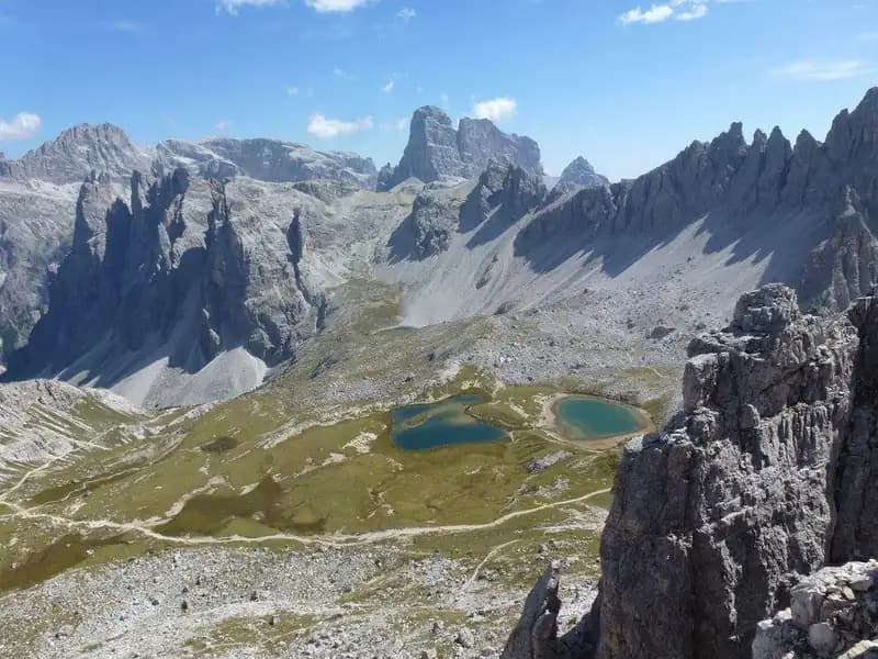
Ferrata Cappellano Hosp
Torre di Toblin · Belluno · Italy
Technical data
- Difficulty
- Moderatamente Difficile
- Status
- aperta
- Distance
- 10,9 km
- Total duration
- 4 h 30 min
- Approach
- 1 h 30 min
- Ferrata time
- 30 min
- Elevation gain
- 317 m
- Max altitude
- 2617 m
Route planning
How to plan Ferrata Cappellano Hosp
Ferrata Cappellano Hosp is in Torre di Toblin, Belluno, Italy and is rated Moderatamente Difficile. Available route data lists about 4 h 30 min total time, 10,9 km of distance, 317 m of elevation gain.
For day planning, consider an approach of about 90 min, about 30 min on the cable, a maximum altitude near 2617 m. Reported route features include: Interesse Storico.
The page includes a parking or driving-directions reference. A GPX track is available to review and download.
As with every via ferrata, evaluate season, lingering snow, storms, crowds and equipment condition. Page last updated on 7/4/2026.
Features
Description
Overview
The Ferrata Cappellano Hosp is a fixed-rope route that unfolds along the northeast face of the Torre di Toblin, in the Tre Cime di Lavaredo group. It is a route of moderate difficulty, characterized by pleasant climbing and limited exposure. It is often used as an ideal descent route to close the loop after tackling the more challenging Ferrata delle Scalette on the way up.
Approach
Access is from the Rifugio Auronzo (2320 m). To reach it, you drive a scenic 7 km toll road from Misurina. Misurina is connected to both Cortina d'Ampezzo and Auronzo di Cadore, as well as to Dobbiaco in the Val Pusteria.
From the parking lot, follow the trail toward the Rifugio Lavaredo and climb to Forcella Lavaredo. From here, descend briefly, then ascend again to the Rifugio Locatelli (2450 m), taking about 1 hour and 15 minutes. Continuing according to the red triangle trail markers heading north, you reach the base of the Torre di Toblin. The entire approach takes about 1 hour and 30 minutes.
At the base of the tower, you have a choice. For the recommended loop, head left (northwest) to climb the Ferrata delle Scalette and then descend via the Cappellano Hosp. Alternatively, you can climb directly via the Ferrata Hosp by heading right (northeast). The Scalette route has more technical sections that make it inadvisable for descent, while the Cappellano Hosp is perfectly suited for travel in either direction.
Via Ferrata
The start of the route is marked by a military post from the Great War with a gun slit. It begins with an easy traverse to the right, followed by a first short vertical step of about six meters. After this, the line turns decisively to the right, tackling several well-holded rock steps, initially without a cable.
The wall's morphology is typical of the Dolomites, with slabs and cracks on solid rock. The route develops across a series of ledges and gullies that ensure a continuous and pleasant pace, without overly exposed sections. A short uphill trail section, with a left-hand curve, leads to perhaps the most physical passage of the entire ascent: an exposed but well-holded arête. Beyond this, you climb a long succession of small rock steps over a base of scree, which requires some attention.
You then overcome another rather pronounced step and follow a diagonal ledge to the right. The climb continues by tackling a series of very climbable rock steps, which lead you to shift first left and then back right. The character of the route is predominantly vertical, but the passages are always well-equipped and of moderate difficulty, offering fun and scenic climbing. A long ascending section to the left finally leads to the summit ridge, which is also equipped. Following it to the right quickly brings you to the summit cross of the Torre di Toblin (2617 m). The climbing time from the start of the ferrata is about 30 minutes, for a total of about 2 hours from the beginning of the hike.
Descent
As mentioned, the recommended descent is back along the same Ferrata Cappellano Hosp, which in this direction proves to be easy and safe. Once back down at the base of the Torre di Toblin, retrace the approach trail to return to the Rifugio Auronzo. The total time for the loop hike is about 4 hours.
Useful Notes
The Ferrata Cappellano Hosp is characterized by short vertical sections and easy rock steps, feeling for long stretches like real climbing without excessive technical difficulty. It is therefore suitable even for beginners or those with modest via ferrata experience. It is important to remember that if chosen as the ascent route, you will then have to descend it, which is still doable but slightly more challenging than the climb.
This ferrata lends itself perfectly to being combined with the Ferrata delle Scalette in a beautiful loop around the Torre di Toblin. From the Rifugio Locatelli, you can also extend the hike southeast toward Monte Paterno to tackle the spectacular Ferrata Innerkofler-De Luca, which leads back to Forcella Lavaredo. In the vast area of the Sesto Dolomites, numerous alternatives exist, such as the Sentiero Attrezzato Bonacossa, the Ferrata Merlone toward Misurina, or toward Sesto the Ferrata Capitano Bilgeri, the Ferrata dei Costoni, and the famous Strada degli Alpini.
Track and weather
Plan the route
Preview the GPX track from the backend, download it for your GPS device, open parking directions, and check a short forecast before leaving.
Images
FAQ
What level of commitment does this via ferrata require?
ferrata.faqAnswers.commitment
How much elevation gain should I plan for?
The listed ferrata elevation gain is 317 m. Also consider approach, return and maximum altitude, because they can matter more than the equipped section alone.
Where is the route located?
Ferrata Cappellano Hosp is located in Torre di Toblin, Belluno, Italy. Before leaving, check parking, access and current local conditions.
When is the best time to climb it?
The best season depends on altitude, aspect and lingering snow. Avoid storms, wet rock and uncertain conditions; start early and keep a margin for the return.
Gear and safety planning
Use the technical data on this page to plan equipment, timing and offline navigation. For a general checklist, read the equipment guide before opening the route in the app.
Video
Watch the route
Useful YouTube videos for getting a real feel for the route before you go.
Logbook
Route condition reports
Recent community notes about closures, snow, equipment damage, trail issues and current conditions.
Community
Reviews, check-ins and photos
-
0 reviews
0
0 climbers
0
Shared by the community
Community photos
Recent images uploaded by Sferrati members.
No community photos yet
Open this route in the app to add the first photo.
Reviews
Recent impressions from climbers who know the route.
No reviews yet
Be the first to review this via ferrata from the app.
Continue in the app
Track the climb, save maps offline, and sync this route to your personal profile.
Use the app to climb
Offline maps, tracking, saves, and profile sync.
Scan the code before leaving, install the app, and keep your route data ready when reception fades.
