
Iarno
Jun 14, 2026
Bella Bella --- **Mi è piaci...
Bella Bella
ModerataEsposizioneVistaAttrezzatura

Appenino Tosco-Emiliano · Reggio Emilia · Italy
Route planning
Ferrata Barranco del Dolo is in Appenino Tosco-Emiliano, Reggio Emilia, Italy and is rated Difficile. Available route data lists about 1 h 30 min total time, 1,7 km of distance, 135 m of elevation gain.
For day planning, consider an approach of about 20 min, about 60 min on the cable, a maximum altitude near 950 m. Reported route features include: Avvicinamento corto.
The page includes a parking or driving-directions reference. A GPX track is available to review and download.
As with every via ferrata, evaluate season, lingering snow, storms, crowds and equipment condition. Page last updated on 7/4/2026.
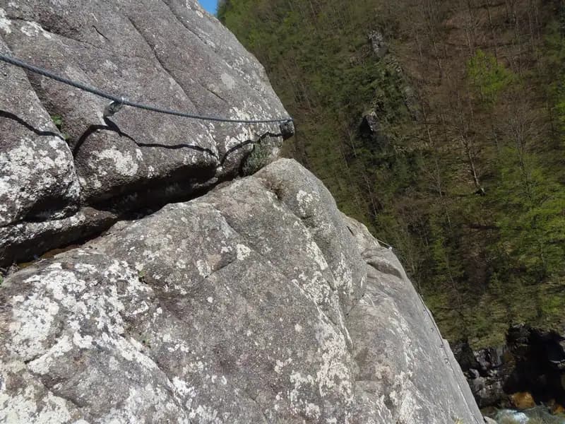
In the upper Apennines of Reggio Emilia, the Ferrata Barranco del Dolo unfolds along a narrow and spectacular blade of sandstone, a rocky ridge that rises roughly two hundred meters above the bed of the stream that gives it its name. Opened in 2015, the route starts from the Dolo riverbed and climbs with sustained technical commitment until it gains the road to Civago. The itinerary runs over compact, polished rock, offering a rewarding alpine experience despite its limited length; the setting is defined by the constant presence of the watercourse flowing just a few meters below, heightening the sense of exposure.
Access is from the provincial road to Civago. Coming from Reggio Emilia, just after passing through a tunnel, you'll find a few pull-offs on the left side suitable for parking. The trailhead sign is more visible for those arriving from Civago; coming from the south, you need to look carefully after a rocky outcrop for the markers and the track that enters the woods. The precise coordinates are 44.26426, 10.48398.
The approach is unusual: from the parking area you actually descend along a steep trail marked with white blazes. In about twenty minutes you reach the bed of the Dolo stream. Following the waymarks, you arrive at the start of the via ferrata, positioned just a couple of meters above the water level. This initial downhill section already prepares you for the enclosed, damp environment of the gorge.
The progression begins with an oblique traverse that climbs gradually, immediately introducing the type of rock-compact and often polished sandstone. Next come the first vertical sections, not extreme but significant, which define the technical and physical character of the route. The vertical passages are challenging but fun, aided in some spots by metal stirrups that help overcome the smoothest surfaces. After a third vertical section, a short grassy stretch leads to the base of a smooth slab, which is climbed directly using fixed handholds.
Beyond the slab, a traverse offers a brief breather before the crux of the climb, reached about twenty minutes from the start. You then tackle a very exposed horizontal traverse, round an edge, and enter an open chimney. The first part of the chimney requires a straddling progression on the wall opposite the cable line. After a few meters, the difficulty increases dramatically, making it almost necessary to pull on the steel cable to overcome this tricky section, which would correspond to 5th grade in free climbing. This passage extends for about fifteen meters. Once past it, you emerge onto a comfortable ledge, an ideal spot for a rest; here you can notice the bolts of a rock climbing route on the opposite wall of the blade. At this point, about thirty minutes have passed.
You resume with another horizontal and exposed traverse, similar to the previous one but shorter. The difficulties ease, though a couple of firm pulls on the cable are still needed to reach some useful handholds that allow access to the final part of the via ferrata (about 45 minutes from the start).
Once this slab is finished, the route continues with a gentle secured up-and-down along the crest line, finally offering a more relaxed and panoramic progression. The Ferrata Barranco del Dolo ends at the summit logbook, positioned beneath the final stretch of the rocky blade, after about an hour of continuous climbing from the start.
From the summit, an obvious trail joins a CAI path within a few minutes near some climbing crags. Keeping left, you quickly ascend toward the paved road, reaching the initial parking area in a short time.
The via ferrata has a moderate overall difficulty, but should not be underestimated due to the two vertical slabs, which are exposed and have few natural holds in their final sections. These two short stretches significantly raise the overall commitment, making the route unsuitable for beginners or unfit individuals. The equipment is in excellent condition. The ideal seasons for the route are spring and autumn, and in mild winters, even the winter season. Caution is advised on the final meters of ledge before the start, as the Dolo stream can have a considerable flow at certain times of the year. This route pairs well with the nearby Ferrata del Monte Penna, reachable with a five-minute drive and a half-hour approach.
Track and weather
Preview the GPX track from the backend, download it for your GPS device, open parking directions, and check a short forecast before leaving.
ferrata.faqAnswers.commitment
The listed ferrata elevation gain is 135 m. Also consider approach, return and maximum altitude, because they can matter more than the equipped section alone.
Ferrata Barranco del Dolo is located in Appenino Tosco-Emiliano, Reggio Emilia, Italy. Before leaving, check parking, access and current local conditions.
The best season depends on altitude, aspect and lingering snow. Avoid storms, wet rock and uncertain conditions; start early and keep a margin for the return.
Use the technical data on this page to plan equipment, timing and offline navigation. For a general checklist, read the equipment guide before opening the route in the app.
Video
Useful YouTube videos for getting a real feel for the route before you go.
Logbook
Recent community notes about closures, snow, equipment damage, trail issues and current conditions.
Community
5.0
2 reviews
14
3 climbers
26
Shared by the community
Recent images uploaded by Sferrati members.
Recent impressions from climbers who know the route.
Track the climb, save maps offline, and sync this route to your personal profile.
Use the app to climb
Scan the code before leaving, install the app, and keep your route data ready when reception fades.

