
Technical data
- Difficulty
- Medio
- Status
- aperta
- Distance
- 4,9 km
- Total duration
- 2 h
- Approach
- 30 min
- Ferrata time
- 40 min
- Elevation gain
- 120 m
- Max altitude
- 2485 m
Route planning
How to plan Ferrata Col Rodella
Ferrata Col Rodella is in Col Rodella, Trento, Italy and is rated Medio. Available route data lists about 2 h total time, 4,9 km of distance, 120 m of elevation gain.
For day planning, consider an approach of about 30 min, about 40 min on the cable, a maximum altitude near 2485 m. Reported route features include: Scale, Avvicinamento corto, Funivia all'andata, Funivia al ritorno.
The page includes a parking or driving-directions reference. A GPX track is available to review and download.
As with every via ferrata, evaluate season, lingering snow, storms, crowds and equipment condition. Page last updated on 7/4/2026.
Features
Description
Overview
The Ferrata al Col Rodella is a fixed-rope route of modest length and low-to-medium difficulty, set on the slopes of the namesake peak in the immediate vicinity of Passo Sella. This crossroads between the Val di Fassa and Val Gardena offers quick access to a route defined by its compactness: both the approach and descent are very short. This makes it an ideal choice for days with tight weather windows or for anyone seeking a technical, alpine experience that doesn't drag on, without sacrificing a spectacular high-mountain setting.
Approach
The logical starting point is Passo Sella. From the pass, look for a narrow paved road that climbs steeply on the Fassa side toward Rifugio Valentini. You can drive up it for about a hundred meters and park at the roadside before the no-through-traffic sign begins. From Rifugio Valentini (2213 m), take the dirt track, which coincides with trail CAI 557, heading southwest. This wide, comfortable path leads first to Rifugio Salei (2222 m) and then to the top station of the cable car coming from Campitello di Fassa (alternatively, you can start directly from here using the lift). Right beneath the cable car cables, an unmarked trail begins, contouring horizontally around the rocky base of Col Rodella for about five minutes until it emerges onto a broad scree slope. Ascending diagonally across this slope brings you to a small, indistinct grassy terrace that marks the start of the via ferrata. The total time from the car is about 30 minutes of easy walking, mostly over gentle terrain.
Via Ferrata
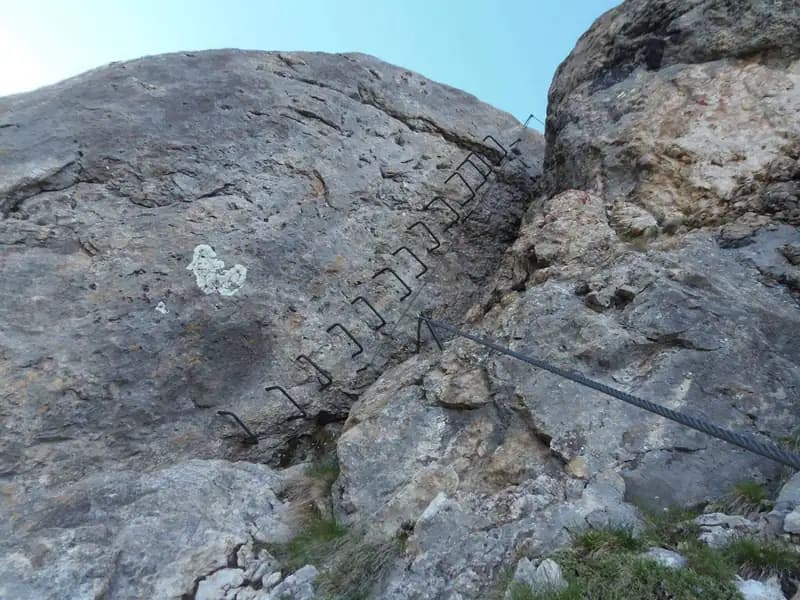
From the start, gear up with your harness and begin climbing on a wall well-endowed with holds. The route initially unfolds over slabs and small crags of dolomitic limestone that are easy to climb, gaining elevation at a steady pace. It then swings decisively left toward a large boulder, which you skirt around via a short exposed traverse along a natural ledge. Next comes a chimney of moderate difficulty, easily overcome by stemming or using side holds. Immediately after, you face a wall of rock polished smooth by erosion, which will require some upper-body pulling power to conquer-this marks the first significant technical crux. Once past this, you arrive at the foot of a wall equipped with a solid row of metal staples, making the ascent easier. At the top, you encounter the second most challenging section: a new smooth slab, short but again demanding some arm strength to overcome the limited footholds. The pace then becomes more fluid along a long, highly exposed wall that is extraordinarily rich in natural holds and edges, allowing you to climb freely while soaking in the growing exposure. Finally, you reach an airy traverse that lets you round a prominent corner, offering a breathtaking view of the valley below. Beyond this, you ascend a few easy rock steps and emerge directly onto the terrace of Rifugio Col Rodella at 2484 meters. The view of the Sella Group and the Val di Fassa far below is magnificent and sudden, capping off this short but intense climb. The time on the via ferrata is about 40 minutes, for a total of 1 hour and 30 minutes from the car.
Descent
From Rifugio Col Rodella, descend along a comfortable trail (marked with CAI signage) that, with wide switchbacks, traverses the grassy and scree-covered slope of the mountain until it rejoins the junction you encountered on the way up near the cable car top station. From there, return via the ascent route to the parking area. The descent from the rifugio takes about 30 minutes of walking on a well-defined path, bringing the total excursion time to around 2 hours.
Useful Notes
The Ferrata Col Rodella stands out for its brevity within the offerings of the Val di Fassa, making it an excellent option for those seeking a technical but not overly demanding activity, or for those new to the world of via ferratas. The rock, dolomitic in nature and often polished smooth by weathering, can become particularly slippery; it is therefore not recommended to tackle it right after heavy rain or when damp. For navigation, using dedicated maps of the area is advised. From Passo Sella, you can embark on other famous and far more challenging via ferratas, such as the Ferrata Oskar Schuster on the Sassolungo or the Ferrata Mesules on the Sella Group. Descending toward Canazei and Passo Pordoi, you'll find the difficult Ferrata Cesare Piazzetta on Piz Boè and, toward the Padon, the Ferrata delle Trincee or the Ferrata dei Finanzieri on Colac. In the opposite direction, toward Val Gardena, you can seek out the challenges of the Ferrata Tridentina or the Ferrata Sass Rigais.
Track and weather
Plan the route
Preview the GPX track from the backend, download it for your GPS device, open parking directions, and check a short forecast before leaving.
Images
FAQ
What level of commitment does this via ferrata require?
ferrata.faqAnswers.commitment
How much elevation gain should I plan for?
The listed ferrata elevation gain is 120 m. Also consider approach, return and maximum altitude, because they can matter more than the equipped section alone.
Where is the route located?
Ferrata Col Rodella is located in Col Rodella, Trento, Italy. Before leaving, check parking, access and current local conditions.
When is the best time to climb it?
The best season depends on altitude, aspect and lingering snow. Avoid storms, wet rock and uncertain conditions; start early and keep a margin for the return.
Gear and safety planning
Use the technical data on this page to plan equipment, timing and offline navigation. For a general checklist, read the equipment guide before opening the route in the app.
Video
Watch the route
Useful YouTube videos for getting a real feel for the route before you go.
Logbook
Route condition reports
Recent community notes about closures, snow, equipment damage, trail issues and current conditions.
Community
Reviews, check-ins and photos
-
0 reviews
0
0 climbers
0
Shared by the community
Community photos
Recent images uploaded by Sferrati members.
No community photos yet
Open this route in the app to add the first photo.
Reviews
Recent impressions from climbers who know the route.
No reviews yet
Be the first to review this via ferrata from the app.
Continue in the app
Track the climb, save maps offline, and sync this route to your personal profile.
Use the app to climb
Offline maps, tracking, saves, and profile sync.
Scan the code before leaving, install the app, and keep your route data ready when reception fades.
