
Technical data
- Difficulty
- Difficile
- Status
- aperta
- Distance
- 9,5 km
- Total duration
- 7 h
- Approach
- 1 h 15 min
- Ferrata time
- 3 h 45 min
- Elevation gain
- 264 m
- Max altitude
- 2035 m
Route planning
How to plan Ferrata del Vajo Scuro
Ferrata del Vajo Scuro is in Prealpi Vicentine, Vicenza, Italy and is rated Difficile. Available route data lists about 7 h total time, 9,5 km of distance, 264 m of elevation gain.
For day planning, consider an approach of about 75 min, about 225 min on the cable, a maximum altitude near 2035 m.
The page includes a parking or driving-directions reference. A GPX track is available to review and download.
As with every via ferrata, evaluate season, lingering snow, storms, crowds and equipment condition. Page last updated on 7/4/2026.
Description
Overview
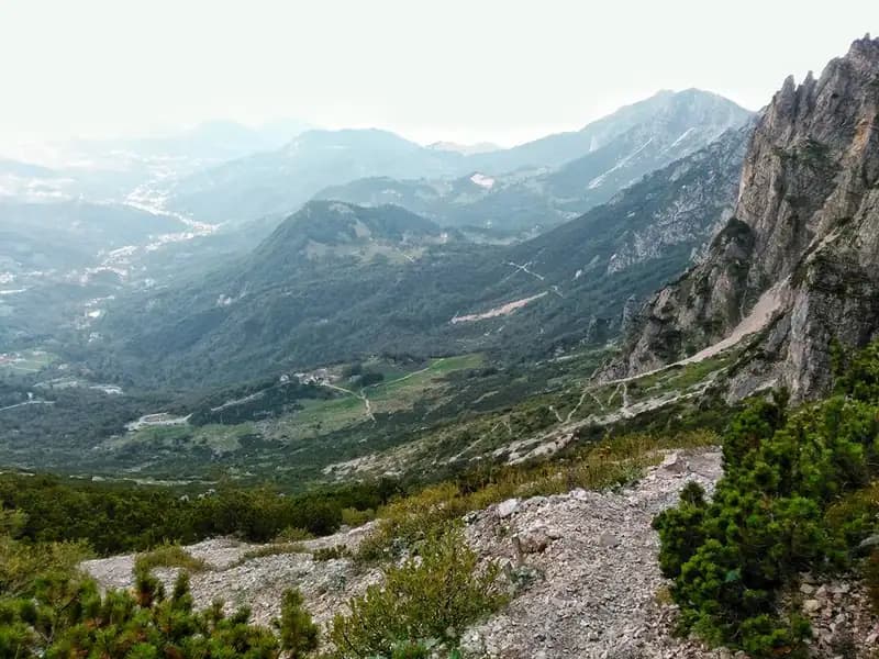
This description covers the route that combines the Ferrata del Vajo Scuro with the Lontelovare variant, a long, complex itinerary featuring numerous equipped sections, some of which are notably demanding. The hike involves a steep approach followed by discontinuous elevation changes with repeated ups and downs. Pay close attention to the trail markers, which can be scarce or hard to spot, especially after completing the Vajo Scuro and during the return leg. The starting point is the Rifugio Cesare Battisti alla Gazza, at an elevation of 1275 meters near Recoaro Terme.
Approach
To reach the rifugio from Recoaro Terme, follow the brown signs heading east, keeping left through the town to enter the valley. After passing the locality of Parlati, you'll drive along a narrow, winding road full of switchbacks for about 7 km. It's best to park roughly 200 meters before the rifugio, at the last curve, where a designated area with a notice board and CAI trail signpost offers enough space.
From the parking area (1250 m), head north on Sentiero 105, starting off on a gentle grade. On your left, you'll come across the junction for Sentiero 113, which will be your return route, but continue straight on the 105 as the climb begins. After about 20 minutes, you reach a fork: the left branch ascends into the Vajo di Pelagatta, while you keep right on Sentiero 105, re-entering the woods. Continuing on, you arrive at another marked junction where you bear left on CAI 105, with signs pointing to Vajo Scuro. The gradient now becomes steep, with a few short sections equipped with fixed ropes, until you reach the Selletta Poe at 1515 meters, about an hour from the parking area; this saddle is marked by two distinctive rock pinnacles. Continue north, skirting the base of rock walls, until you intercept the first steel cable near the Vajo di Lovaraste (1550 m), reached in about 1 hour and 15 minutes.
Via Ferrata
The equipped itinerary begins with a descent that leads to the base of the narrow Vajo di Lovaraste. You descend diagonally to a vertical passage equipped with stirrups and rungs, then arrive at a ledge that you traverse to the left. The ledge progressively narrows, offering minimal but sufficient holds. You continue descending diagonally to an 8-10 meter vertical drop, overcome using stirrups and fixed handles. The final section, more stepped, leads to the bottom of the gully, covered in large boulders. Descend along the gully, watching for loose stones and staying on the right side where metal fixtures are present at the most critical points, until the equipment temporarily stops.
Emerging on the opposite slope, follow a faint trail to a junction, reached about 15 minutes from the start. Here you face a choice: to the left, a steel cable marks the beginning of the Lontelovare variant, of very high difficulty, which leads to the start of the Ferrata del Vajo Scuro. To the right, the trail leads in 10 minutes to the Vajo di Lazocli, from where you ascend toward the imposing Torrione Recoaro to reach the original start of the Ferrata del Vajo Scuro in about 40 minutes. However, due to a landslide, this route is currently impassable, making the Lontelovare variant mandatory.
The Lontelovare variant begins with a diagonal ascent of the wall on rock and earth, of moderate difficulty. After a horizontal section, you reach the base of a beautiful vertical wall. The initial section, equipped with handles, is vertical, while the upper part offers better natural holds. Once the wall is finished, a traverse to the right becomes progressively more challenging. The cable then resumes vertically up a very demanding wall with slightly overhanging passages, representing the greatest technical difficulties encountered so far. After overcoming this section, a narrow ledge to the right leads to steps on exposed, earthy terrain, then you tackle a 6-meter dihedral, climbed using fixtures on both sides. Another ledge to the right precedes a stepped wall, where the earthy floor can be slippery.
You now find yourself at the foot of another vertical wall. Supported by numerous metal handles, you ascend this section, similar to the previous one but more challenging and with more slightly overhanging passages, for about 35-40 meters to a narrow ledge. Continue vertically on more stepped but equally exposed rock, using the last handles to exit the wall onto a path through the mugo pines. A ledge to the right leads near the Torrione Recoaro; keeping right, you enter the Vajo Scuro, where the original Ferrata del Vajo Scuro begins, reached about 45 minutes from the start of the variant.
The Ferrata del Vajo Scuro unfolds inside a narrow and evocative gorge. From an elevation of 1645 meters, about an hour from the start at the Vajo di Lovaraste, you ascend the gully floor with the aid of the cable until you encounter the first fixtures. The cable rises vertically with an initial slightly overhanging passage, leading through a narrow gap. After passing through, you enter the gully's channel to the left, heading toward the most iconic passage of the route. You squeeze tightly between the two walls on the left side, climbing toward a hole through which you must pass with agility and strength. Holds, both natural and artificial, are present, but movement is limited; bulky backpacks are strongly discouraged. Continue vertically along the crack, overcoming some wedged boulders, then exit.
From a small ledge at the exit of the crack, you ascend again on the right side of the gully, tackling a beautiful vertical wall to bypass a boulder blocking the way. After the first vertical meters, the cable bends left and the climb becomes more slabby. You easily climb over some rocks along the path, finally exiting the Vajo Scuro and reaching a saddle at 1812 meters, about 40 minutes from the start in the gorge.
Once on the saddle, follow a mid-slope trail to the left that cuts across a debris-filled valley. Ignore the first gully and continue toward a second one that climbs in the direction of a prominent wedged boulder. Upon reaching the steel cable on the left side, ascend a 4-meter step beyond which you spot the characteristic boulder resting on both sides of the gully, known as the Porta dell'Inferno (Hell's Gate). Pass under it without difficulty and continue on the opposite slope, tackling a descending section. Still on the left side, the cable descends diagonally using large wedged boulders as support until the final stretch. After completing this demanding descent, the equipped section of the Ferrata del Vajo Scuro ends, about an hour from the start in the gorge.
Now continue on a faint trail, turning around to admire the rock notch ("Orecchia del Diavolo" or Devil's Ear) you've just passed. The trail, exposed and only partially equipped, leads toward the Forcella della Scala at 1850 meters, reached in 15 minutes from the Orecchia del Diavolo (about 2h 15' from the total start, including the variant), where another peculiar wedged boulder is present. On the opposite slope, you reach an unmarked junction where you join Sentiero 195: to the right, you descend to Campogrosso, while you keep left in ascent, proceeding among spires and stunning views of the Piccole Dolomiti, until you reach the Forcella del Lovaraste at 1919 meters, in about 30 minutes from Forcella della Scala (2h 45' from the total start). From here, the ascent to Punta Lovaraste, recognizable by its large metal cross, is optional.
Looking north, Monte Cornetto and Baffelan are clearly visible, as well as the Pasubio. Continue ascending toward the Cima Centrale del Fumante, encountering some equipped sections in exposed passages, then descend toward the Forcella del Fumante at 1905 meters, reached in 30 minutes from Forcella Lavaraste. From here, you can either traverse the ridge toward Passo dell'Obante and the summit of Obante (1h), or descend toward the Rifugio Scalorbi below. Opting for the latter, descend until you join Sentiero 109, which reaches the Passo di Pelegatta at 1776 meters (30' from Forcella del Fumante, 3h 45' from the total start, 5h total), where the rifugio stands.
Descent
For the return, two options are possible: descend along the narrow Vajo Pelegatta (not recommended) or continue along the wide Sentiero 182 heading south to a junction. Here, keep left following the CAI Sentiero 113 "Omo e Dona." The trail starts descending, briefly ascends, then drops steeply through switchbacks and mugo pines. Once you reach the trail taken on the approach, follow it in reverse to the right back to the parking area, in about 2 hours from Rifugio Scalorbi, for a total of about 7 hours.
Useful Notes
The combined Ferrata del Vajo Scuro and Lontelovare variant is difficult and demanding. The two vertical sections of the variant require good athletic strength and training. While it doesn't present technically prohibitive passages, the cumulative difficulty, including some overhanging sections, and the overall length classify this hike as certainly challenging. The itinerary is very rewarding, offering magnificent views and a great variety of passages despite the modest elevation. Watch out for the typical afternoon fog in the area and the sometimes outdated trail markers: it's advisable to start early in the morning. Also pay attention to the landslide affecting the end of the via ferrata. Given the difficulty of some sections, knowing techniques for safely resting on a via ferrata can be useful. For maps, a detailed map of the Pasubio and Vallagarina is recommended. This itinerary lends itself to being combined with other ferratas in the Piccole Dolomiti, such as the Ferrata Biasin, the Sentiero Attrezzato Pojesi, the Ferrata Campalani, the Gramolon ferratas, or the Sentiero Attrezzato Baglioni, also allowing overnight stays in rifugi for multi-day excursions.
Technical and Environmental Analysis
The itinerary unfolds over morphologically complex terrain, characterized by narrow gorges (vai), secondary ridges, and compact limestone walls. The rock, typical of the Piccole Dolomiti, is solid but in some stepped sections can present an earthy, debris-covered floor that requires caution. The progression continuously alternates between vertical cable sections and horizontal traverses on often narrow ledges, imposing a discontinuous and physically demanding rhythm.
The route is predominantly vertical and technical in its central part (Lontelovare variant and Vajo Scuro), where the difficulty lies in the exposure, the slightly overhanging passages, and the need for arm strength. The overall length and the numerous ups and downs following the ferrata add a physical endurance component. The panoramic aspect is remarkable, especially in the final section on Sentiero 195, which offers wide views of the surrounding spires and the Pasubio massif. The rocky environment of the gorge is spectacular but demanding, requiring continuous concentration for choosing holds and managing tight spaces.
Track and weather
Plan the route
Preview the GPX track from the backend, download it for your GPS device, open parking directions, and check a short forecast before leaving.
Images
FAQ
What level of commitment does this via ferrata require?
ferrata.faqAnswers.commitment
How much elevation gain should I plan for?
The listed ferrata elevation gain is 264 m. Also consider approach, return and maximum altitude, because they can matter more than the equipped section alone.
Where is the route located?
Ferrata del Vajo Scuro is located in Prealpi Vicentine, Vicenza, Italy. Before leaving, check parking, access and current local conditions.
When is the best time to climb it?
The best season depends on altitude, aspect and lingering snow. Avoid storms, wet rock and uncertain conditions; start early and keep a margin for the return.
Gear and safety planning
Use the technical data on this page to plan equipment, timing and offline navigation. For a general checklist, read the equipment guide before opening the route in the app.
Video
Watch the route
Useful YouTube videos for getting a real feel for the route before you go.
Logbook
Route condition reports
Recent community notes about closures, snow, equipment damage, trail issues and current conditions.
Community
Reviews, check-ins and photos
-
0 reviews
0
0 climbers
0
Shared by the community
Community photos
Recent images uploaded by Sferrati members.
No community photos yet
Open this route in the app to add the first photo.
Reviews
Recent impressions from climbers who know the route.
No reviews yet
Be the first to review this via ferrata from the app.
Continue in the app
Track the climb, save maps offline, and sync this route to your personal profile.
Use the app to climb
Offline maps, tracking, saves, and profile sync.
Scan the code before leaving, install the app, and keep your route data ready when reception fades.
