
Ferrata Zandonella alla Croda Rossa di Sesto
Croda Rossa di Sesto · Belluno · Italy
Technical data
- Difficulty
- Difficile
- Status
- aperta
- Distance
- 9,6 km
- Total duration
- 8 h
- Approach
- 3 h 30 min
- Ferrata time
- 1 h
- Elevation gain
- 236 m
- Max altitude
- 2936 m
Route planning
How to plan Ferrata Zandonella alla Croda Rossa di Sesto
Ferrata Zandonella alla Croda Rossa di Sesto is in Croda Rossa di Sesto, Belluno, Italy and is rated Difficile. Available route data lists about 8 h total time, 9,6 km of distance, 236 m of elevation gain.
For day planning, consider an approach of about 210 min, about 60 min on the cable, a maximum altitude near 2936 m. Reported route features include: Itinerario lungo, Interesse Storico.
The page includes a parking or driving-directions reference. A GPX track is available to review and download.
As with every via ferrata, evaluate season, lingering snow, storms, crowds and equipment condition. Page last updated on 7/4/2026.
Features
Description
Overview
The Ferrata Mario Zandonella cuts across the southern face of the Croda Rossa di Sesto, offering a short but intensely demanding route. Overall, the itinerary is long and physically taxing, with technical passages that require good arm strength, not always supported by optimal handholds. The route is a mandatory loop: the via ferrata must be descended in reverse unless you opt for a longer alternative that skirts the mountain.
Approach
The starting point is the Rifugio Lunelli (1568 m), accessible from the Belluno side of the Passo Monte Croce di Comelico. From the hut, take trail 101, which initially crosses gently sloping pastures before veering south and climbing a long, steep series of switchbacks. These lead, in about an hour, to the Rifugio Berti (1950 m), set in a wide basin dominated by Monte Popera, in the heart of the Dolomiti di Sesto. From this hiking hub, continue on trail 101 heading north, ascending the debris-strewn Vallone Popera toward the Passo della Sentinella. The steady climb unfolds along the left orographic side until you intercept trail 124 near Lago di Popera. Keeping left and following red markings on the rock, you ascend a glacial moraine. Just before the Passo Sentinella, a large boulder marked by a plaque and a red sign indicates the start of the ferrata to the right (2500 m), reachable in about 3 hours from the parking area. From here, briefly scramble up loose scree to a ledge where the metal protections begin, marked by a small sign. The total approach time is approximately 3 hours and 30 minutes.
Via Ferrata
The equipped route begins with a ledge on unstable terrain that rounds a corner, immediately introducing the environment of ledges and slabs typical of the face. You then tackle the first rocky sections, with the cable on the right, on a slope that progressively steepens until it becomes a fairly vertical wall. This leads to a vertical ladder with the cable on the left. Once past it, the ferrata continues along a very vertical line of ascent with few handholds and increasing exposure, demanding a steady, controlled pace. You reach a more climbable section, characterized by good holds but equally exposed. Next comes the most technical passage of the route: a very vertical gully about twenty meters long, carved into compact dolomite, where the lack of structured holds in some spots forces a strength-based climb. This is the most challenging and exposed section of the Ferrata Zandonella and leads to a wide panoramic balcony.
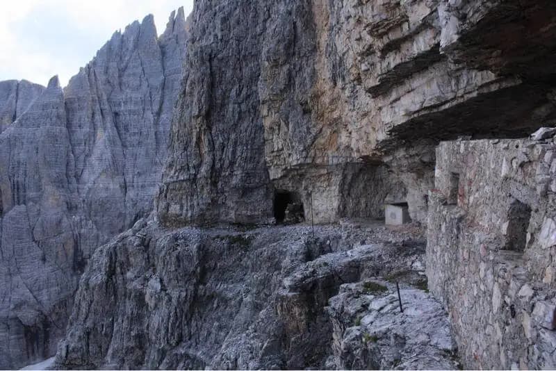
Here you encounter a WWI Italian shelter (2835 m) carved into the rock, a relic of the Great War. You then traverse an exposed, unprotected ledge to the right-an adrenaline-pumping stretch that requires a steady step and sets you up for the final difficulty. This consists of ascending a short, loose but equipped gully, marking the end of the route's protections. The view suddenly opens onto the Val Pusteria. Shifting left a few meters, you intercept the normal route, which quickly leads to the summit cross of Croda Rossa di Sesto (2936 m). The ferrata itself takes about 1 hour, for a total of 4 hours and 30 minutes from the start.
Descent
Route 1 (east variant) The most logical descent is via the east variant, restored after a landslide in 2017 and now perfectly passable. From the summit cross, take the only visible ferrata facing toward Val Grande. It begins with a steep, non-trivial descent, leading to a path among the rocks. Descend following red markers toward a permanently snow-covered basin, which you cross to reach another ferrata section going uphill. At its end, traverse equipped ledges, noting caves to the left. The final ledge ends with a short unroped section that leads to a large boulder marked with a triangle and an arrow with a cross, indicating a descent to the right. Follow this last ferrata stretch to the start of a steep scree slope. From here, with no further markings, descend cautiously along the debris slope until you rejoin the main approach trail. The descent takes about 3 hours and 30 minutes from the summit, for a total of 8 hours.
Route 2 (north side) Alternatively, you can descend on the north side, initially equipped with ropes and a ladder. The suggestion is to continue the descent along the Ferrata dei Costoni di Croda Rossa, then skirt the mountain at mid-height via trail 15B and then 15. Finally, follow trail 171, which descends to the Rifugio Lunelli. This option, taking about 4 hours from the summit (total 8h 30'), is definitely longer than the descent via the renovated east variant.
Useful Notes
The Ferrata Zandonella sparks mixed opinions: the grand setting and commanding position are offset by a rather long approach for a short ferrata, leading to a summit also reachable via the Ferrata dei Costoni-a shorter, less difficult route with 400 meters less elevation gain. Despite this, the climb remains a magnificent and rewarding experience, albeit strenuous. The equipment on the ascent, recently renovated, is in good condition; the cable, now tighter, makes the more vertical sections easier. Caution is advised for possible falling debris, especially in the gully prone to rockfall. The descent via the east variant has also been renovated, and the equipment is excellent; some sections, both on the ascent and descent, are non-trivial and require focus, as does the final steep scree slope. For maps, a detailed map of the Dolomiti di Sesto is recommended.
Track and weather
Plan the route
Preview the GPX track from the backend, download it for your GPS device, open parking directions, and check a short forecast before leaving.
Images
FAQ
What level of commitment does this via ferrata require?
ferrata.faqAnswers.commitment
How much elevation gain should I plan for?
The listed ferrata elevation gain is 236 m. Also consider approach, return and maximum altitude, because they can matter more than the equipped section alone.
Where is the route located?
Ferrata Zandonella alla Croda Rossa di Sesto is located in Croda Rossa di Sesto, Belluno, Italy. Before leaving, check parking, access and current local conditions.
When is the best time to climb it?
The best season depends on altitude, aspect and lingering snow. Avoid storms, wet rock and uncertain conditions; start early and keep a margin for the return.
Gear and safety planning
Use the technical data on this page to plan equipment, timing and offline navigation. For a general checklist, read the equipment guide before opening the route in the app.
Video
Watch the route
Useful YouTube videos for getting a real feel for the route before you go.
Logbook
Route condition reports
Recent community notes about closures, snow, equipment damage, trail issues and current conditions.
Community
Reviews, check-ins and photos
-
0 reviews
0
0 climbers
0
Shared by the community
Community photos
Recent images uploaded by Sferrati members.
No community photos yet
Open this route in the app to add the first photo.
Reviews
Recent impressions from climbers who know the route.
No reviews yet
Be the first to review this via ferrata from the app.
Continue in the app
Track the climb, save maps offline, and sync this route to your personal profile.
Use the app to climb
Offline maps, tracking, saves, and profile sync.
Scan the code before leaving, install the app, and keep your route data ready when reception fades.
