
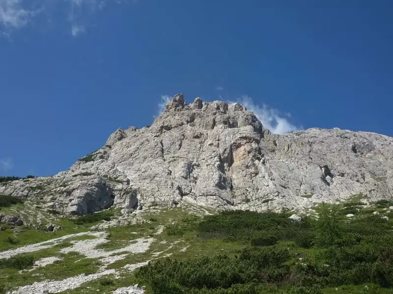
Ferrata Martini al Campanile di Colesei
Dolomiti di Sesto · Belluno · Italy
Technical data
- Difficulty
- Difficile
- Status
- aperta
- Distance
- 5 km
- Total duration
- 4 h
- Approach
- 1 h
- Ferrata time
- 1 h 30 min
- Elevation gain
- 723 m
- Max altitude
- 2291 m
Route planning
How to plan Ferrata Martini al Campanile di Colesei
Ferrata Martini al Campanile di Colesei is in Dolomiti di Sesto, Belluno, Italy and is rated Difficile. Available route data lists about 4 h total time, 5 km of distance, 723 m of elevation gain.
For day planning, consider an approach of about 60 min, about 90 min on the cable, a maximum altitude near 2291 m.
The page includes a parking or driving-directions reference. A GPX track is available to review and download.
As with every via ferrata, evaluate season, lingering snow, storms, crowds and equipment condition. Page last updated on 7/4/2026.
Description
Overview
The Via Ferrata Bepi Martini is a recently built route on the Comelico side of the Sexten Dolomites, ending at the Colle di Colesei. Though not especially long, the route offers a highly scenic itinerary marked by a distinctly vertical character. The finale presents a choice between a more demanding direct variant and an easier alternative, allowing you to tailor the final challenge.
Approach
Access to the route starts from the Rifugio Lunelli (1568 m), reachable from the Belluno side of the Passo Monte Croce di Comelico. From the pass, descend and turn right onto Via Valgrande, following it to its end near the hut. A longer alternative involves parking at the pass and following the Sentiero 124 directly to the Colle di Colesei. This description refers to the start from the Rifugio Lunelli. From here, follow the Sentiero 171 (or, alternatively, a longer military road) toward the Forcella Pian della Biscia. Once at the saddle, continue uphill to the north (keeping right) on a military road, exiting the forest and heading toward the Vallo Alpino bunker (structure 10). After about fifteen minutes, you cross the Sentiero 124 coming from the left from the Rifugio Berti (useful for the return), which you ignore. Continue for a few minutes in a northwesterly direction until you spot, on the left, a track marked with red blazes that climbs steeply through the dwarf pines toward the south and east faces of the Colle di Colesei. With a few steep switchbacks, you quickly reach the start of the Via Ferrata Bepi Martini Barzolai.
The approach begins on comfortable trails and dirt roads, then concentrates on a steep track that scrambles up through sparse vegetation. This final section prepares you for the change in pace, gradually bringing the hiker to the foot of the dolomite wall where the vertical adventure begins.
Via Ferrata
The ferrata is a classic ascent on dolomite rock. The first section is very climbable, with compact, solid rock and an exposure that builds progressively. The route exploits the weaknesses in the face, featuring passages of real climbing. The ascent is vertical and alternates between slab sections, dihedrals, and more slabby sequences, punctuated by a couple of traverses of moderate difficulty.
The route is continuous and physically engaging, with no long rests or horizontal sections to recover. The morphology is typically dolomitic, with the route snaking over smooth slabs and vertical structures, using natural ledges and gullies. The pace is sustained, requiring good arm endurance and constant awareness of the exposure, which becomes increasingly airy as you climb.
Reaching the upper part of the route, you face a fork. The right-hand variant is more challenging and exposed: it follows an airy ridge section before requiring a fairly demanding descent toward a saddle. The left-hand variant is easier and leads without particular technical difficulty to the same saddle. From here, after the final few meters, the equipped section ends. Climbing to the right, you finally reach the Croda Sora di Colesei (2291 m), rewarded with a magnificent panorama of the nearby dolomite peaks. The time from the start is about one hour.
The final choice between the two variants radically changes the character of the last stretch: the right is technical and exposed, with a short but intense ridge passage and a challenging descent; the left offers a more relaxed and manageable conclusion. Both converge at the panoramic summit.
Descent
Before starting the return, it's worth turning to admire the spire of the Colle di Colesei you've just conquered. The descent options are varied and allow for interesting loop itineraries. The shortest return to the Rifugio Lunelli involves following, from the end of the fixed cables, a track that quickly joins the Sentiero 122. Keeping left on the descent, you reach the ruins of the Rifugio Olivo Sala. From here, the quickest and steepest option descends to the trail junction encountered on the approach, then returns to the Rifugio Lunelli (about 1 hour and 30 minutes from the end of the ferrata). Alternatively, you can detour to the nearby Rifugio Berti and descend to the Lunelli via the more comfortable Sentiero 101.
The return is on well-marked trails, often over gravelly or grassy terrain, with slopes that are sometimes steep but free of technical difficulty. The descent allows you to appreciate the surrounding dolomite environment from different angles, completing the experience with a more relaxing walk.
Useful Notes
This Via Ferrata Bepi Martini was built and inaugurated in 2020. It is a vertical route of good commitment, especially in the second section, but very pleasant and climbable. The first part is of moderate difficulty, while the upper part, including the challenging variant and the descent section, requires greater attention. The equipment is new and excellent, with a balanced mix of passages on natural rock and on metal structures placed only where necessary. The panoramas of the Comelico and the Sexten Dolomites are exceptional.
The route lends itself well to being included in multi-day itineraries in the eastern sector of the Sexten Dolomites, and can be combined, for example, with the Ferrata Zandonella or the Ferrata della Croda Rossa di Sesto. The mountain guide Bepi Martini Barzolai, to whom the route is dedicated, was a historic figure of the Comelico and managed both the Rifugio Lunelli and the Rifugio Berti at different times.
The itinerary offers a complete experience: technical for the climbing passages, physical for the continuity of the ascent, and scenic for the breathtaking views enjoyed from the summit. The excellent rock and modern equipment make it an ideal choice for those seeking a classic but not trivial ferrata in an authentic, less crowded dolomite environment.
Track and weather
Plan the route
Preview the GPX track from the backend, download it for your GPS device, open parking directions, and check a short forecast before leaving.
Images
FAQ
What level of commitment does this via ferrata require?
ferrata.faqAnswers.commitment
How much elevation gain should I plan for?
The listed ferrata elevation gain is 723 m. Also consider approach, return and maximum altitude, because they can matter more than the equipped section alone.
Where is the route located?
Ferrata Martini al Campanile di Colesei is located in Dolomiti di Sesto, Belluno, Italy. Before leaving, check parking, access and current local conditions.
When is the best time to climb it?
The best season depends on altitude, aspect and lingering snow. Avoid storms, wet rock and uncertain conditions; start early and keep a margin for the return.
Gear and safety planning
Use the technical data on this page to plan equipment, timing and offline navigation. For a general checklist, read the equipment guide before opening the route in the app.
Video
Watch the route
Useful YouTube videos for getting a real feel for the route before you go.
Logbook
Route condition reports
Recent community notes about closures, snow, equipment damage, trail issues and current conditions.
Community
Reviews, check-ins and photos
-
0 reviews
0
0 climbers
0
Shared by the community
Community photos
Recent images uploaded by Sferrati members.
No community photos yet
Open this route in the app to add the first photo.
Reviews
Recent impressions from climbers who know the route.
No reviews yet
Be the first to review this via ferrata from the app.
Continue in the app
Track the climb, save maps offline, and sync this route to your personal profile.
Use the app to climb
Offline maps, tracking, saves, and profile sync.
Scan the code before leaving, install the app, and keep your route data ready when reception fades.
