Overview
The Ferrata Malfatti is an ideal introduction to climbing via ferratas, with a moderate technical challenge. It ascends Monte Sumbra in the Apuan Alps, starting from the Passo Fiocca side. The route runs mostly across exposed grassy slopes, where the steel cable serves more as a safety handrail than an essential support, making it closer in concept to a protected hiking trail. This itinerary is therefore an excellent choice for beginners who want to try this type of activity in a highly rewarding panoramic setting.
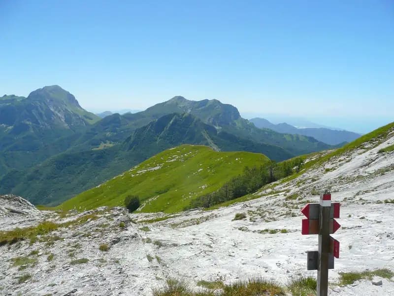
The environment is classic Apuan, with a route that winds over grassy and marble slopes, offering steady but not overly strenuous progress. The character is predominantly scenic and walk-based, with exposure defining the grassy ledges but never reaching high levels of vertical or technical difficulty.
Approach
The route starts from the village of Arni, in the province of Lucca. Access is via the SP 13 road, either from the Garfagnana side or the Versilia side. From Castelnuovo Garfagnana, turn right before the tunnel and head up toward Campagrina and Arni. Coming from Versilia, pass through the tunnel and turn left. Park near the church, which is clearly visible.
From here, climb the staircase behind the church and take a road heading uphill toward the last houses, where the CAI trail 144 to Passo Fiocca (1560 m) begins. The trail initially climbs steeply through the woods, then traverses along the south face of Monte Fiocca; the path is not always well marked, so pay attention to the trail markers. After about 1 hour and 40 minutes, you pass the Malpasso section, an unprotected, slightly more complex and exposed passage. You then enter a beech forest, cross two small streams (often dry), and exit the woods heading toward a saddle across a grassy stretch. From the saddle, climb a steep slope, first over easy rock slabs and then bare marble, until you reach Passo Fiocca after about 2 hours and 30 minutes total.
From the pass, turn right onto CAI trail 145, which leads in about 15 minutes to the narrow west face of Monte Sumbra and the start of the via ferrata (2h 45' total from the parking lot).
The approach alternates steep sections with long traverses, maintaining a steady but consistent pace. The environment evolves from the dense vegetation at lower elevations to open ledges and upper grassy slopes, typical of the Apuan landscape.
Via Ferrata
The Ferrata Malfatti climbs the south slope of Monte Sumbra. Despite its initially challenging appearance, the route reveals a character closer to a protected hiking trail than a technical via ferrata. It starts by climbing a few rock slabs, then tackles a series of exposed grassy ledges, where the cable provides reliable support. It is worth noting that the equipment is not all in excellent condition. About 30 minutes from the start, the protected route joins the main trail to the summit of Monte Sumbra (3h 15' total). Turning left in a steep climb, you reach the summit in a few minutes, which offers a rewarding panorama of the Apennine ridge, the sea, and the Apuan Alps group (3h 25' total).
The progression is horizontal and diagonal, developing across wide grassy ledges supported by a continuous cable. When rock is present, it is the typical Apuan marble, polished by erosion. The pace is fluid and walk-like, with exposure accompanying the route constantly without ever becoming overwhelming, making it more a pleasant scenic ascent than a technical climb.
Descent
From the summit, descend back along the same Ferrata Malfatti to Passo Fiocca. At this point, you have two main options. The first is to descend the steep CAI trail 144 back to Arni, taking about 2 hours from the mountain for a total of around 5 hours and 30 minutes.
The second option, once at Passo Fiocca, is to continue straight on CAI 144 (with the possibility of a detour to the summit of Monte Fiocca, about 40 minutes round trip). This trail skirts the north face of Monte Fiocca and leads to Passo Sella in about 2 hours from Monte Sumbra (5h 30' total). From Passo Sella, follow the CAI trail 31 downhill to the left, which after a stretch becomes a marble quarry road and returns to Arni, for a total of about 6 hours and 30 minutes.
The descent via CAI 144 is direct and physical, while the loop via Passo Sella offers a more varied pace, with a long high-altitude traverse followed by a gradual descent on a dirt road, extending the time but reducing impact on the joints.
Useful Notes
This itinerary is recommended for hikers approaching via ferratas for the first time, thanks to its modest technical difficulties and the opportunity to summit a peak. It is essential to exercise extreme caution in bad weather or on wet ground: some sections of CAI trail 144 between Arni and Passo Fiocca can become particularly tricky and slippery. The via ferrata was installed in 1987. For navigation, it is advisable to use a detailed map of the Apuan Alps. Given the length and elevation gain of the excursion, it is difficult to combine with other itineraries on the same day, but you could consider staying in the area to tackle other via ferratas in the southern Apuans on subsequent days.
The overall experience is a long but not extreme hike, where the protected section adds variety and safety in a high-mountain setting. The main satisfaction lies in reaching a significant summit with accessible technical demands, immersed in the unique landscape of the Apuan Alps.