
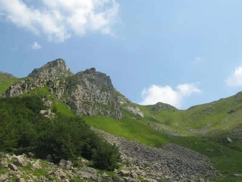
Sentiero Attrezzato Monte Gendarme
Monte Gendarme · Massa-Carrara · Italy
Technical data
- Difficulty
- Facile
- Status
- aperta
- Distance
- 13 km
- Total duration
- 3 h 30 min
- Approach
- 1 h 45 min
- Ferrata time
- 15 min
- Elevation gain
- 47 m
- Max altitude
- 1895 m
Route planning
How to plan Sentiero Attrezzato Monte Gendarme
Sentiero Attrezzato Monte Gendarme is in Monte Gendarme, Massa-Carrara, Italy and is rated Facile. Available route data lists about 3 h 30 min total time, 13 km of distance, 47 m of elevation gain.
For day planning, consider an approach of about 105 min, about 15 min on the cable, a maximum altitude near 1895 m.
The page includes a parking or driving-directions reference. A GPX track is not available yet, so bring an alternative map source.
As with every via ferrata, evaluate season, lingering snow, storms, crowds and equipment condition. Page last updated on 7/4/2026.
Description
Overview
The route up Monte Gendarme (1872 m), which branches off the main crest of the Tuscan-Emilian Apennines near the Passo del Cerreto, is no longer a via ferrata. All metal fixtures, including ladders and cables, have been removed. Reaching the summit now requires overcoming a short but decisive sequence of rock climbing, rated at Grade II, entirely devoid of fixed protection and therefore needing to be safeguarded with your own gear. The route winds through the rugged and captivating Vallone dell'Inferno, offering the chance to combine the ascent with the nearby and higher Monte La Nuda (1895 m) for a hike of remarkable scenic impact.
The environment is characterized by a marked morphological evolution: from the broad valley basin, you ascend on a trail to the rocky slopes of the Gendarme, a compact structure that rises isolated on the ridge. The rhythm of the hike is initially steady and physical along the valley, then transforms into a sudden, concentrated technical challenge on the final wall. The character of the route is therefore twofold: a classic hiking approach followed by a short alpine section, dry and exposed, which demands specific preparation.
Approach
The logical starting point is the Passo del Cerreto (1261 m), well-served by State Road 63 and equipped with parking. From here, take trail 00, which climbs the entire Vallone dell'Inferno at a constant gradient. The well-maintained and marked path passes the Bivacco Rosario and leads to the main watershed in about 1 hour and 30 minutes. This junction is key: turning left diverts you to the summit of Monte La Nuda (a further 15 minutes or so), while keeping right continues on CAI trail 94. This section skirts the valley on almost level ground, offering the first close-up views of the compact south face of Monte Gendarme, until reaching its base. The full approach from the parking lot to this point takes about 1 hour and 45 minutes.
The valley environment is typically glacial-nival, with wide alluvial fans and a trail that often develops on grassy ledges or among boulders. The pace is a steady but regular climb, with no technical passages, allowing you to gain elevation progressively. The experience is that of a classic high-altitude hike, with the panorama gradually opening up toward the surrounding peaks.
Via Ferrata
Fundamental warning: the final section is not a via ferrata. The former equipped route has been dismantled. The climb to the summit of Monte Gendarme therefore resolves into a short but intense sequence of rock climbing on solid rock (Grade II), now completely unprotected and to be managed independently with a rope and quickdraws. Once past this technical obstacle, you emerge onto the small, panoramic summit. The total time from the start is about 2 hours.
The wall presents itself as a compact rocky outcrop of marly limestone, requiring vertical and careful progression. The exposure is significant, and the environment changes radically: from the broad sweep of the trail, you shift to the concentration of a few decisive meters of climbing. The character of this section is purely alpine: technical, exposed, and psychologically demanding, representing the heart of the entire ascent. The view from the summit is magnificent: it spans from the Apuan Alps to the Gulf of La Spezia, along the entire Tuscan-Emilian ridge as far as the Alpe di Succiso and the profile of Monte Cusna.
Descent
The retreat follows the same itinerary. From the summit of Monte Gendarme, it takes about 1 hour and 30 minutes to return to the Passo del Cerreto, bringing the total hike time to around 3 hours and 30 minutes, excluding any technical stops for rope management.
The descent from the climbing section demands maximum attention, being the most critical and potentially most dangerous passage of the entire day. The pace therefore becomes slow and methodical near the wall, then regains fluidity once back on the main trail. The overall experience concludes with a long, rapid descent along the valley.
Useful Notes
The hike, up to the base of the wall, is straightforward and on an excellently marked trail on the Emilian side. The final climb, though short, radically transforms the nature of the outing, making it an excellent training ground for experienced hikers who wish to tackle climbing moves to be managed in complete autonomy, both on the ascent and descent. Given the removal of the equipment, it is essential to correctly assess your own technical skills and rock evaluation abilities. At the end, back at your vehicle, you can consider visiting the famous via ferratas of the Pietra di Bismantova, reachable in about an hour by car along SS 63 toward Castelnuovo ne' Monti.
Track and weather
Plan the route
Preview the GPX track from the backend, download it for your GPS device, open parking directions, and check a short forecast before leaving.
GPX track unavailable
This route does not include a downloadable track yet.
Images
FAQ
What level of commitment does this via ferrata require?
ferrata.faqAnswers.commitment
How much elevation gain should I plan for?
The listed ferrata elevation gain is 47 m. Also consider approach, return and maximum altitude, because they can matter more than the equipped section alone.
Where is the route located?
Sentiero Attrezzato Monte Gendarme is located in Monte Gendarme, Massa-Carrara, Italy. Before leaving, check parking, access and current local conditions.
When is the best time to climb it?
The best season depends on altitude, aspect and lingering snow. Avoid storms, wet rock and uncertain conditions; start early and keep a margin for the return.
Gear and safety planning
Use the technical data on this page to plan equipment, timing and offline navigation. For a general checklist, read the equipment guide before opening the route in the app.
Video
Watch the route
Useful YouTube videos for getting a real feel for the route before you go.
Logbook
Route condition reports
Recent community notes about closures, snow, equipment damage, trail issues and current conditions.
Community
Reviews, check-ins and photos
-
0 reviews
0
0 climbers
0
Shared by the community
Community photos
Recent images uploaded by Sferrati members.
No community photos yet
Open this route in the app to add the first photo.
Reviews
Recent impressions from climbers who know the route.
No reviews yet
Be the first to review this via ferrata from the app.
Continue in the app
Track the climb, save maps offline, and sync this route to your personal profile.
Use the app to climb
Offline maps, tracking, saves, and profile sync.
Scan the code before leaving, install the app, and keep your route data ready when reception fades.
