
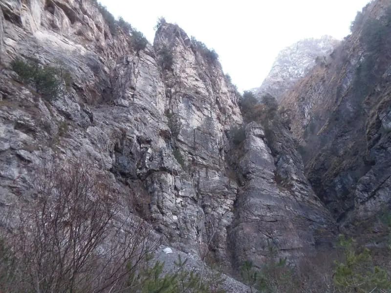
Ferrata Palestra di Roccia Val Gallina
Prealpi Bellunesi · Belluno · Italy
Technical data
- Difficulty
- Difficile
- Status
- aperta
- Distance
- 1 km
- Total duration
- 1 h 30 min
- Approach
- 5 min
- Ferrata time
- 30 min
- Elevation gain
- 90 m
- Max altitude
- 560 m
Route planning
How to plan Ferrata Palestra di Roccia Val Gallina
Ferrata Palestra di Roccia Val Gallina is in Prealpi Bellunesi, Belluno, Italy and is rated Difficile. Available route data lists about 1 h 30 min total time, 1 km of distance, 90 m of elevation gain.
For day planning, consider an approach of about 5 min, about 30 min on the cable, a maximum altitude near 560 m. Reported route features include: Avvicinamento corto.
The page includes a parking or driving-directions reference. A GPX track is available to review and download.
As with every via ferrata, evaluate season, lingering snow, storms, crowds and equipment condition. Page last updated on 7/4/2026.
Features
Description
Overview
The Val Gallina Climbing Gym, also known as the VII Reggimento Alpini, offers two main routes that unfold across the compact limestone bastion of the wall. The Ferrata A is rated as easy, though it maintains continuous and considerable exposure. The Ferrata B, on the other hand, receives a difficult rating, featuring at least two sections that demand a good dose of arm strength and climbing technique. These are short, training-oriented routes, ideal for a quick outing even in the cold season. Since 2019, a third option has been added, the Ferrata C, described as difficult and athletic.
Approach
The starting point is the parking lot of the Climbing Gym in Val Gallina. To reach it, head toward Soverzene, in the province of Belluno, on the eastern side of the Piave River. From the south, you arrive at Soverzene by passing through Pian di Vedoia and crossing the bridge over the river. After passing the hydroelectric plant-from which the nearby Ferrata Parete dei Falchi branches off-you enter the town. Leaving the built-up area, take via Val Gallina heading north. At a fork near a small religious building, keep left toward Longarone. After a few hundred meters, you'll find signs for the climbing gym parking lot.
Access to the base is immediate. From the parking lot, following the signs toward the imposing wall, you cross a stream. In just a few minutes, you're faced with the choice: the wall to the left hosts the easy Ferrata A, while the pronounced dihedral to the right marks the start of the more technical Ferrata B.
Via Ferrata
Ferrata A Moving left for about fifteen meters, the route begins with a diagonal ramp of roughly ten meters. You then tackle a section of vertical wall, seemingly severe but made smooth by a dense sequence of rungs and stirrups. A new ramp to the left leads beneath what is probably the most characteristic passage of the route: a vertical and exposed narrow chimney, well-equipped. After overcoming it, you traverse a narrow, airy ledge to the left, climb an easy chimney, and make a traverse to the right. The climb concludes with a few simple steps. The climbing time from the start is about 15 minutes (30 minutes total from the parking lot).
Ferrata B From the choice area, head right, briefly descending to the stream where the start is located. After the first few meters of diagonal cable, the climb becomes vertical, and after about four meters, you encounter an overhanging section. The rock forms a bulge, and the cable rises to the right of it, while the best holds-both natural and artificial (stirrups)-are found on the left. It's advisable to move decisively through the roughly three meters of overhang to overcome this key passage. You then emerge onto a small ledge.
You climb a short connecting section over rocky steps that gradually bends left, leading beneath a chimney. The cable starts on the left side of the chimney before crossing to the right, where you ascend with the help of some stirrups and natural footholds. Exiting the chimney, you traverse three meters diagonally to the right to reach a long series of metal rungs that allow you to climb a smooth wall. This vertical section ends on a narrow ledge, which is traversed to the left.
The ledge ends near a short dihedral, which you climb to access the key passage of the route: a demanding traverse. The first part goes around an edge, overcoming a rocky roof with the aid of rungs. The traverse proper is initially horizontal, airy, and on very smooth rock. Once completed, the cable rises diagonally inside a crack (with good footholds) and then diagonally to the right. Ahead, you see new metal rungs, but to reach them, you must tackle another demanding ascending traverse to the right. After overcoming it, you find yourself beneath a vertical and slightly overhanging wall, equipped with stirrups and rungs.
Exiting this decisive passage, the wall becomes more slabby, and a rung with some pegs aids progress. The final section begins: beneath a long wall, you tackle two long series of metal rungs, connected by a short diagonal traverse of three meters. After climbing the second series, the cable bends right into a mixed ramp of dirt and rock that goes around an edge and concludes the ferrata. The climbing time from the start is about 30 minutes (about 50 minutes total from the parking lot).
Ferrata C The description for this route, opened in 2019 and rated as difficult and athletic, is currently being prepared.
Descent
Ferrata A The return is via a faint trail that starts to the left of the route's end and descends to the starting point, then back to the parking lot (about 20 minutes from the end of the ferrata).
Ferrata B From the end of the route, follow the trail that continues left until reaching the arrival point of Ferrata A. From there, descend along the same descent path as Ferrata A to the parking lot (total loop time about 1 hour and 30 minutes).
Useful Notes
For enthusiasts, a recommended itinerary is to climb Ferrata B followed by descending via Ferrata A. Ferrata B is undoubtedly the more challenging of the two, with passages not to be underestimated, such as the initial overhanging section, the chimney, and the key traverse, justifying its difficult rating despite its brevity. Ferrata A, while very exposed, does not present particularly difficult technical passages.
The routes have been recently re-equipped, and cables and gear are in good condition, with a thick cable even if not always perfectly taut. However, it must be noted that a section of Ferrata B (updated 2017) shows rock instability, with a bolt partially detached, requiring maximum caution.
Given the proximity to the Ferrata Parete dei Falchi and the short duration of both, they are excellent to combine in a single day or as a return leg from ferratas further north. Continuing toward Longarone, you'll find the demanding Ferrata della Memoria al Vajont. To the east, you can encounter the Ferrata Costacurta or the Alta Via dei Rondoi, while to the west, on the Schiara group, challenging routes like the Sperti, the Berti, the Mormol, and the Zacchi are concentrated.
Track and weather
Plan the route
Preview the GPX track from the backend, download it for your GPS device, open parking directions, and check a short forecast before leaving.
Images
FAQ
What level of commitment does this via ferrata require?
ferrata.faqAnswers.commitment
How much elevation gain should I plan for?
The listed ferrata elevation gain is 90 m. Also consider approach, return and maximum altitude, because they can matter more than the equipped section alone.
Where is the route located?
Ferrata Palestra di Roccia Val Gallina is located in Prealpi Bellunesi, Belluno, Italy. Before leaving, check parking, access and current local conditions.
When is the best time to climb it?
The best season depends on altitude, aspect and lingering snow. Avoid storms, wet rock and uncertain conditions; start early and keep a margin for the return.
Gear and safety planning
Use the technical data on this page to plan equipment, timing and offline navigation. For a general checklist, read the equipment guide before opening the route in the app.
Video
Watch the route
Useful YouTube videos for getting a real feel for the route before you go.
Logbook
Route condition reports
Recent community notes about closures, snow, equipment damage, trail issues and current conditions.
Community
Reviews, check-ins and photos
-
0 reviews
0
0 climbers
0
Shared by the community
Community photos
Recent images uploaded by Sferrati members.
No community photos yet
Open this route in the app to add the first photo.
Reviews
Recent impressions from climbers who know the route.
No reviews yet
Be the first to review this via ferrata from the app.
Continue in the app
Track the climb, save maps offline, and sync this route to your personal profile.
Use the app to climb
Offline maps, tracking, saves, and profile sync.
Scan the code before leaving, install the app, and keep your route data ready when reception fades.
