
Technical data
- Difficulty
- Difficile
- Status
- aperta
- Distance
- 11 km
- Total duration
- 11 h
- Approach
- 1 h
- Ferrata time
- 9 h
- Elevation gain
- 1028 m
- Max altitude
- 2878 m
Route planning
How to plan Ferrata Costantini alla Moiazza
Ferrata Costantini alla Moiazza is in Moiazza, Belluno, Italy and is rated Molto Difficile. Available route data lists about 11 h total time, 11 km of distance, 1028 m of elevation gain.
For day planning, consider an approach of about 60 min, about 540 min on the cable, a maximum altitude near 2878 m. Reported route features include: Itinerario lungo.
The page includes a parking or driving-directions reference. A GPX track is available to review and download.
As with every via ferrata, evaluate season, lingering snow, storms, crowds and equipment condition. Page last updated on 7/4/2026.
Features
Description
Overview
The Ferrata Gianni Costantini on the south face of the Moiazza stands out for its exceptional length, considerable elevation gain, and duration, placing it as a unique route in the national via ferrata scene. The route offers a varied sequence of demanding passages, including exposed ridge and ledge sections, sometimes without protection. The challenging nature of the route demands meticulous planning, excellent physical condition, and solid experience in alpine terrain.
Access is from the Passo Duran (BL), the orographic junction between the Val Zoldana and Val Cordevole. Operations begin from the square of the Rifugio Tomè, located at the pass.
Approach
The itinerary immediately announces itself as a grand undertaking, with a positive elevation gain exceeding 1200 meters, bringing you to nearly 3000 meters in altitude on the summit. The combination of length and technical passages makes it feasible only for fit hikers, after checking for stable weather conditions and with a departure in the early morning hours.
From Passo Duran (1605 m), take the CAI trail 549 heading to Rifugio Bruto Carestiato (1834 m). The route develops at the foot of the imposing Sass del Duran, the southern bastion of the Moiazza Group, climbing with a steady gradient up the sunny side of the massif. Ignore a branch to the right for the Cengia Letizia, and proceed among patches of mountain pine until you gain the refuge in about 45 minutes. Here, a large red mark on the rock wall clearly indicates the start of the route. A short connection leads to the metal plaque marking the beginning of the Ferrata Costantini, reached in about an hour from the parking lot.
Via Ferrata
The first section opens with a long and physically demanding diagonal traverse to the left. The first 50 meters, characterized by limited handholds, require balanced movement, favoring foot placements to preserve arm energy. The diagonal climb leads to a dihedral, overcome in strong exposure, after which you continue the traverse to a very narrow, highly exposed ledge. Then follow short slabs, easy vertical steps, and sections of broken rock, maintaining the leftward direction, until you intercept a key traverse marked by a yellowish-toned wall and a red dot. This diagonal passage on a polished slab, though provided with some holds, must be tackled decisively. Two metal pegs offer a rest before the subsequent vertical ascent (1h 15' from the start).
The character of the route changes: for about 60 meters you face a determined vertical climb on compact rock, aided by stirrups and pegs. The first 20 meters are particularly exposed, then the line bends right onto more stepped rock. After overcoming a short step in a narrow gully and a few meters of broken rock, you arrive at a trail section that leads to the Pala del Belia (2295 m - 1h 45' from the start).
A new section begins with a traverse to the left and an exposed small wall, entering inside a gully enclosed between high walls. The climb on jagged rock is technically simple. A vertical passage of 6-8 meters, aided by a couple of pegs, allows you to exit the gully. You then traverse an unprotected ledge to the right, before tackling a vertical small wall and a well-holded slab. A sequence of steps and exposed ledges leads to a chimney of modest difficulty that brings you to Cima Cattedrale (2557 m - 2h 30' from the start).
You set off again following a red arrow to the left. After a first step, the trail clearly indicates the continuation toward the ridge. You traverse sloping ledges and short steps, with a more demanding passage on polished rock of about 6 meters. After overcoming a 15-meter wall, you exit onto sloping broken rock and reach the Cresta delle Masenade, with the summit of the Moiazza Sud standing out ahead (3h from the start).
The route continues along the ridge, alternating easy passages with more technical ones; a fixed-rope descent stands out, requiring maximum concentration to reach the Forcella delle Masenade (2650 m). Pay attention to some unprotected passages just below the ridge crest. At the fork, a deviation to the right leads to the Bivacco Grisetti. Continuing, the route becomes less exposed, cutting across a series of long sloping slabs toward the slopes of the Moiazza Sud. A slightly descending ledge introduces the final vertical section (4h from the start).
The cable turns abruptly vertical on blackish-yellowish walls. You climb a step, then proceed diagonally to the right before ascending vertically in a stepped gully. Once the fixed equipment ends, follow the red dots on a sloping plane to the left toward a new ridge crest. At the end of a scree slope, you encounter a fork: right for the summit, left for the Cengia Angelini.
The final stretch toward the summit is decidedly demanding. A diagonal traverse to the right on smooth rock leads onto the exposed ridge. You move to the left side to tackle two airy passages on smooth walls. After a very exposed and unprotected ledge, you pick up the fixed equipment again for a final slab. A trail marked with red dots leads to a false summit, from which you descend a few meters along the ridge before climbing again to the summit of the Moiazza Sud (2878 m - 6h from the start, 7h total). The 360-degree panorama embraces the Pale di San Martino, the Civetta, and the Dolomite groups, in a breathtaking view. Hundreds of meters below, you can see the Bivacco Ghedini.
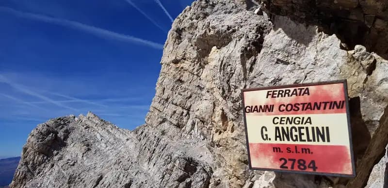
The descent, long and partly equipped, begins by retracing the final section of the via ferrata back to the fork with the Cengia Angelini, paying attention to the exposed passages already encountered. At the fork, turn left for the Cengia Angelini (2784 m - 30' from the summit). You traverse a ledge that is initially wide and easy, but generally unprotected; watch out for any residual snow. The ledge then narrows, becoming equipped, bypassing some corners in an exposed descent but without technical difficulty, until you descend onto an unstable scree slope that leads to the Bivacco Ghedini (2600 m - 1h 30' from the summit).
From the bivouac, descend a gully. After a short equipped descent section, climb back up to the right before beginning the final descent to the valley. You face some demanding passages alternating with trail sections and short rock steps, with a couple of non-trivial equipped sections and smooth slabs. Upon reaching a terminal scree slope near trees and mountain pines, you intersect the CAI trail 554, putting an end to the technical difficulties (3h from the summit, 9h from the start, 10h total).
Descent
From the junction with trail 554, keep left along the comfortable track that skirts the bases of the walls. You reach the Rifugio Bruto Carestiato without difficulty in 30 minutes, and from there return to Passo Duran via the approach trail in another 30 minutes, for a total of about 11 hours.
Useful Notes
The Ferrata Costantini holds a prominent position for the enormous physical commitment and length that characterize it. The technical difficulties, while present, do not reach extreme levels, but the accumulated fatigue, elevation gain, and duration make it suitable only for experienced and very fit hikers. The itinerary is continuous and requires a sustained pace. It is absolutely essential to start at dawn to return in daylight and to tackle the route only with stable weather conditions. The environment is austere and isolated; although there are two escape routes, the consequences of a thunderstorm would be serious. Consider the altitude and the possible presence of snowfields, even late in the season, on unprotected sections, which might require complicated detours or the use of crampons. For technical difficulties, it is classifiable as "difficult," but for physical commitment, it is "extremely difficult," which is why the route is overall considered very difficult.
Track and weather
Plan the route
Preview the GPX track from the backend, download it for your GPS device, open parking directions, and check a short forecast before leaving.
Images
FAQ
What level of commitment does this via ferrata require?
ferrata.faqAnswers.commitment
How much elevation gain should I plan for?
The listed ferrata elevation gain is 1028 m. Also consider approach, return and maximum altitude, because they can matter more than the equipped section alone.
Where is the route located?
Ferrata Costantini alla Moiazza is located in Moiazza, Belluno, Italy. Before leaving, check parking, access and current local conditions.
When is the best time to climb it?
The best season depends on altitude, aspect and lingering snow. Avoid storms, wet rock and uncertain conditions; start early and keep a margin for the return.
Gear and safety planning
Use the technical data on this page to plan equipment, timing and offline navigation. For a general checklist, read the equipment guide before opening the route in the app.
Video
Watch the route
Useful YouTube videos for getting a real feel for the route before you go.
Logbook
Route condition reports
Recent community notes about closures, snow, equipment damage, trail issues and current conditions.
Community
Reviews, check-ins and photos
-
0 reviews
0
0 climbers
0
Shared by the community
Community photos
Recent images uploaded by Sferrati members.
No community photos yet
Open this route in the app to add the first photo.
Reviews
Recent impressions from climbers who know the route.
No reviews yet
Be the first to review this via ferrata from the app.
Continue in the app
Track the climb, save maps offline, and sync this route to your personal profile.
Use the app to climb
Offline maps, tracking, saves, and profile sync.
Scan the code before leaving, install the app, and keep your route data ready when reception fades.
